Ever wondered what the best walks in the Peak District are?
If you’re new to visiting the Peak District and you’re unsure which walks to do, you can find some great ideas here, along with the route maps and details to complete them. This is not just a pretty walk list!
After stretching my legs on hundreds of scenic walks these are my top 15 favourites routes in the Peak District. These beautiful walks include a mix of short, medium and long routes across the White Peak and Dark Peak area of the National Park.
There are hills, rivers to walk alongside, caves to explore, some with waterfalls and a few hidden treasures that you might not have heard of before. Plus, plenty of walks with trigs and Ethels to bag as you go if you’re completing the Trig challenge or Ethel bagging. The wonderful thing about the Peak District is there’s something for everyone to enjoy, so start scrolling to find the perfect walk for you.
Let me know in the comments if you think I’ve missed any best walks off the list?
15 best walks in the Peak District
Here are our 15 best walks in the Peak District.
For each walk suggestion you’ll find a link below with a detailed guide that includes where to start the walk, parking or public transport options, the route map and GPX file, detailed route guidance, plus other useful information about the route.
There are also options to do shorter or longer routes that still include the highlights so there should be plenty of options for your to enjoy your visit.
If you’re beginner hiker then read our guides on What to pack for a day hike and What to do in an emergency situation here.
Mam Tor + The Great Ridge

Distance: 6.8 miles/11 km
Walk time: 3-4 hours
Total ascent: 535 m/1,755 ft
Trigs (1) + Ethels (2)
A classic must-do Peak District walk is Mam Tor and the Great Ridge. Walking up to the summit and enjoying the views of the Hope Valley and surrounding hills is absolutely spectacular.
There are various different routes up to Mam Tor but this 7-mile loop from Castleton is one of the best routes, taking in all the scenery on the way. You’ll reach Mam Tor trig point then enjoy a lovely route along the undulating Great Ridge via Back Tor all the way to Lose Hill.
(Buy our Mam Tor charity patch here.)
Walk route + map hereThe Roaches + Lud’s Church
Distance: 10 miles/17 km
Walk time: 5-6 hours
Total ascent: 761 m/2,497 ft
Trigs (1) + Ethels (3)
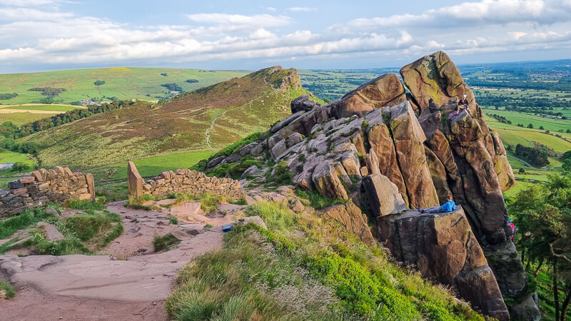
Next on our best walks in the Peak District list is The Roaches and Lud’s Church. Both places are iconic spots in the Peak District but combined on one walk you have the best of both worlds.
This route takes you up via Hen Cloud (an Ethel) with views towards The Roaches and then on to Lud’s Church, known as a secret spot in the Peak District. In reality it’s not that secret as everyone has heard of it! However, visiting Lud’s Church for the first time is a wonderful experience and worth doing on a quieter day if you can as it has a real wow factor.
(Buy our Roaches charity patch here + Lud’s Church patch coming soon.)
Walk route + map hereWolfscote Dale

Distance: 5.4 miles/8.7 km
Walk time: 2.5-3 hours
Total ascent: 262 m/859 ft
Trigs (0) + Ethels (0)
Wolfscote Dale from Hartington is a beautiful walk in the White Peak area of the Peak District. The route takes you through Beresford Dale before reaching Wolfscote Dale alongside the River Dove.
As well as a beautiful dale to explore there are also a couple of caves along the way before looping back down Biggin Dale to complete this circular route to Hartington.
Walk route + map here
Dovestone Reservoir + The Trinnacles from Greenfield

Distance: 12 miles/19 km
Walk time: 6-7 hours
Total ascent: 857 m/2,812 ft
Trigs (1) + Ethels (1)
If you’re looking for a longer hike then this route in the northern part of the Peak District is one for your list.
Once you’ve walked the route you’ll see why it’s on the best walks list as the views are absolutely beautiful and it’s a day you’ll remember. From Greenfield the walk takes you past the reservoirs and up Birchen Clough via a short scramble before you’re up high. There’s also the bonus of seeing the impressive Trinncales before continuing the route along the ridge.
Walk route + map hereCave Dale from Castleton

Distance: 2 miles/3.3 km
Walk time: 1.5-2.5 hours
Total ascent: 205 m/672 ft
Trigs (0) + Ethels (0)
Our second route from Castleton on the list of best walks in the Peak District. Cave Dale is one of those hidden gems that is beautiful to explore on a shorter route.
From the village of Castleton you pop out into this stunning dale, with views above of Peveril Castle, and enjoy this quaint spot in the Peak District.
As a bonus this route can be combined with our other walk on the list, Mam Tor and the Great Ridge, so it’s two great walks in one!
Walk route + map here
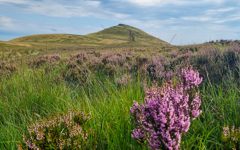
Chrome Hill + Parkhouse Hill from Earl Sterndale

Distance: 4.6 miles/7.4 km
Walk time: 2-3 hours
Total ascent: 425 m/1,394 ft
Trigs (0) + Ethels (2)
Hopping over to the Staffordshire Peak District and a stunning pair of hills – Chrome Hill and Parkhouse Hill.
Our walk takes you up Parkhouse Hill, then on to Chrome Hill from Earl Sterndale, so you have a different perspective of both hills from each summit. The route then loops back via Dowel Dale to complete the circular walk.
(Buy our Chrome Hill charity patch here.)
Walk route + map here
Kinder Scout from Edale

Distance: 8 miles/13 km
Walk time: 5-6 hours
Total ascent: 806 m/2,644 ft
Trigs (1) + Ethels (1)
Another one that had to make the best walks list is Kinder Scout, there are many different start points for this walk and Edale village is one of the most popular ways up.
However, from Edale there are still numerous options to reach the top. Our walk takes you up Grindsbrook Clough, an adventurous route with a short scramble section towards the top of the plateau. From here, you’re up high enjoying the gritstone rock formations as you hike around the Kinder Plateau then on to Kinder Low trig point before heading back down the famous Jacob’s Ladder.
(Buy our Kinder Scout charity patch here.)
Walk route + map here
Chee Dale Stepping Stones

Distance: 5 miles/8 km
Walk time: 2-3 hours
Total ascent: 358 m/1,174 ft
Trigs (0) + Ethels (0)
Another hidden spot in the Peak District that jumps on our best walks list. This route lies beneath the Monsal Trail, a popular trail but Chee Dale is where all the magic moments are!
Head out from Miller’s Dale; a great start point as this is an old train station complete with the train platforms. Then it’s a short walk down the Monsal Trail before heading down to the River Wye and before long you’ll reach the famous Chee Dale Stepping stones. These are passable in most weather, with the exception of the winter month’s when there’s heavy rain and melted snow that raises the water levels of the river.
Walk route + map here
Win Hill + Crook Hill

Distance: 9.1 miles/14.7 km
Walk time: 4-5 hours
Total ascent: 647 m/2,122 ft
Trigs (1) + Ethels (2)
Another route with two gorgeous Peak District Hills both with views of Ladybower Reservoir from different angles. This walk begins with a steep hike up to Win Hill with a trig point, before heading down via woods and back up to Crook Hill, then returning back to the start point.
The bonus of this walk is that it includes two Peak District Ethels as well! If you don’t fancy a long route then these two hills can be hiked individually as well – Win Hill and Crook Hill.
(Buy our Win Hill charity patch here.)
Walk route + map here
Shutlingsloe Hill + Macclesfield Forest
Distance: 5.4 miles/8.7 km
Walk time: 2-3 hours
Total ascent: 383 m/1,256 ft
Trigs (1) + Ethels (1)
Known as the Matterhorn of Cheshire, Shutlingsloe Hill is pretty impressive from most angles. This lovely 5-mile walk takes you up to Shutlingsloe summit where there’s a trig point (also an Ethel), the scenery is stunning from this viewpoint. Then it’s down via Macclesfield Forest and a loop back around to the start of the walk.
Walk route + map here
Thor’s Cave + Manifold Valley

Distance: 4.7 miles/7.5 km
Walk time: 2-3 hours
Total ascent: 343 m/1,125 ft
Trigs (0) + Ethels (0)
From the lovely village of Wetton a short distance away is the magnificent Thor’s Cave. Pictured above it might look small but it’s a huge cave that you can go inside and explore.
This lovely route takes you via the Manifold Valley to Thor’s Cave but also stops off at some other cool caves on the way too. This is a perfect short walk for children as there’s plenty to keep them occupied on the walk.
(Buy our Thor’s Cave charity patch here.)
Walk route + map here
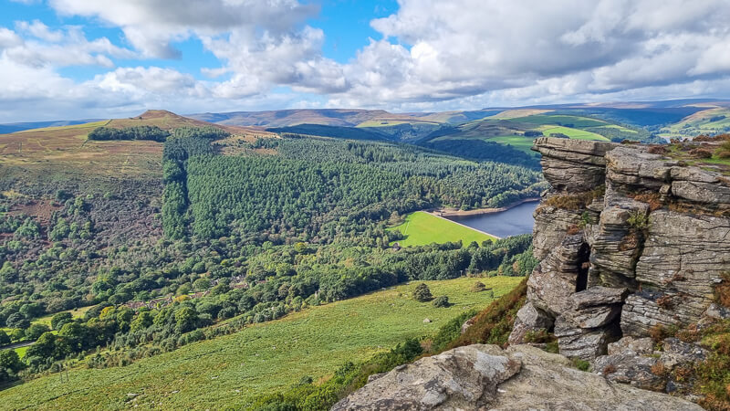
Bamford Edge

Distance: 1.9 miles/3.1 km
Walk time: 1-1.5 hours
Total ascent: 217 m/712 ft
Trigs (0) + Ethels (0)
An absolutely breathtaking walk in the Peak District and this great short route means you can add it on even with a busy schedule for your visit!
Bamford Edge is an outcrop of gritstone rocks, common in the Peak District along with a few other popular edges that are worth a visit, including Stanage Edge, Derwent Edge and Curbar Edge to name a few!
If you’d like to do a sunset walk we have a few other suggestions for great walks to do here – 16 Stunning Sunset Walks In The Peak District
(Buy our Bamford Edge charity patch here.)
Walk route + map here
Dovedale + Thorpe Cloud

Distance: 6.5 miles/10.4 km
Walk time: 3-4 hours
Total ascent: 611 m/2,004 ft
Trigs (0) + Ethels (1)
A lovely route taking in both the popular Dovedale stepping stones and views from the hill Thorpe Cloud that sits in this Derbyshire Dale. The walk then takes you away from the River Dove and Dovedale, on a less-popular route, via Bunster Hill before returning back.
Dovedale stepping stones is an extremely popular place to visit so it’s worth doing this section of the walk when it’s early morning or on an evening.
(Buy our Thorpe Cloud charity patch here.)
Walk route + map here
Higher Shelf Stones + Plane Crash Site

Distance: 5.8 miles/9.3 km
Walk time: 3-3.5 hours
Total ascent: 488 m/1,601 ft
Trigs (1) + Ethels (1)
The Higher Shelf Stones walk is a lovely 6-mile loop from Snake Pass, which includes the B29 Superfortress crash site. However, this walk also includes some stunning scenery from Higher Shelf Stones trig point and along the route via Shelf Brook, which loops round to make this a fantastic circular walk.
Walk route + map here
Derwent Edge

Distance: 8 miles/13 km
Walk time: 3.5-4.5 hours
Total ascent: 493 m/1,617 ft
Trigs (1) + Ethels (2)
From Fairholmes, this lovely walk heads via the impressive Derwent Dam and alongside Derwent Reservoir before heading uphill to the cairn at Lost Lad then on to the trig at Back Tor, the start of Derwent Edge.
Then you can simply walk and enjoy all those gorgeous views from Derwent Edge looking down on Ladybower Reservoir and the hills beyond.
Walk route + map here
Do you have any more questions about which walk to pick? Ask me in the comments below.
Other walk information
Ordnance Survey Walk Maps
For these best walks, there are two maps that cover them OL1 – Peak District (Dark Peak Area) and OL24 – Peak District (White Peak Area)
Shop online at Ordnance Survey
And don’t forget your compass, I recommend the Silva Expedition compass, it’s more expensive but a valuable piece of kit!
For online maps, you can get via OS Online App or Viewranger App.
Check prices here for the one month or yearly option with OS Online App.
More walks in the Peak District
Looking for quieter (or less popular) walks in the Peak District? You might like these circular walks.
- Derbyshire Dales Walk + Anthony Hill From Elton | 6-Mile Route
- Baslow Edge + Birchen Edge Walk From Baslow | 9-Mile Route
- Alport Castles Walk From Ladybower Reservoir (Fairholmes) | 10-Mile Route
- Featherbed Moss, Holme Moss (Black Hill) + Hey Edge Trig Walk From Crowden | 11-Mile Route
Or check out all our Peak District walking routes here
*Peak District Walks participates in the Amazon Services Associates Programme, as well as other affiliate programmes. If you purchase through these, Peak District Walks earn from the qualifying links. This is at no extra cost to you. Read more here.
Peak District Walks is a FREE online resource. Are you enjoying the walks? You can say thank you and buy me a coffee here. Thank you very much 🙂
Peak District charity patches
Read about the charity here.


Charity Patches

Charity Patches

Charity Patches

Charity Patches

Charity Patches

Charity Patches
Need more help planning your Peak District trip?
Join our Peak District walks Facebook page, follow us on Instagram and Twitter for inspiration.
More information on the Peak District, including transport options, where to stay, best Peak District pubs + other useful resources.
Check out the 7 YHAs in the Peak District and find the best walks direct from your accommodation.
Find out what maps you will need for your trip here.
Top tips - Read our useful guides on hiking tips here.
Guided Walks with an introduction to map reading (see dates here).
Visit our hiking recommendations page, (footwear, clothes + kit).
Or get in touch and I will help as best I can :).
Please note 'Peak District Walks' accepts no liability for any injuries or accidents resulting from walking our routes. We always recommend you wear appropriate footwear to avoid injuries and to take a paper map and compass on your walks. Read more here.
Can you recommend a circular walk that goes through most of the tunnels on the monsal trail. Thank you.