
Walking along the Great Ridge from Lose Hill to Mam Tor is one of the best walks in the Peak District. It’s also a very popular walk but when you’re walking along the ridge with the valleys on either side, you’ll see why.
Our route begins from Castleton up to Lose Hill summit then along the Great Ridge, over Back Tor, then on to Hollins Cross and finally Mam Tor. As you walk along the ridge you can see the other Peak District hills in the area, including the highest point Kinder Scout, and then all the way to Win Hill, another must-do route. Then looking down you can see the beautiful village of Castleton and on the other side, you’ll see the lovely village of Edale.
Here you will find details on how to get to the start of the walk from Castleton, route information, a map, a GPX file, facilities on the walk, plus a detailed step-by-step guide of the walk.
Let me know in the comments if you’ve done this walk and what you think!
Buy a printable/downloadable PDF route guide for the walk here.
Lose Hill + Mam Tor walk from Castleton
Walk information + GPX
Walk type: Short circular walk
Distance: 6.8 miles/11 km
Walk time: 3-4 hours
Total ascent: 535 m/1,755 ft
Highest point: 515 m/1,690 ft
Walk highlights: Castleton village, Lose Hill summit, walking along the Great Ridge and summiting Mam Tor and views of the Hope Valley
Trigs: 1 – Mam Tor
Ethels: 2 – Lose Hill and Mam Tor
Stiles: 3
Mam Tor + Lose Hill walk map

© Crown copyright and database rights (2024) OS 002572460
Click for OS online map
Walk start point
Start grid reference: SK 14936 82940
Car parking address: Castleton Visitor Centre, Cross Street, Castleton, S33 8WN – Google location
Although there are plenty of car parking spaces this is a popular place so spaces can fill up if you don’t arrive early. There’s an additional car park further down the road if this one is full.

Parking Cost
Up to 1 hour £1.60
1-2 hours £2.50
2-4 hours £4.00
4-10 hours £6.00
Public transport
Nearest train station: Hope train station (1 mile/2 km)
Want to start from a different location? Check out these other Mam Tor walks that start from Edale, Barber Booth and Hope.
Facilities on the walk
There are public toilets available next to Castleton Visitor Centre. You can also pick up breakfast (if you’re late started as the cafe doesn’t open until 10 am) and snacks for your hike.
There are also plenty of other little shops and cafes in Castleton where you can treat yourself to goodies either before or after the walk. There are also several pubs for that after-walk drink.
There are no further shops or additional toilet facilities on this walk. Also once you’re up walking along the Great Ridge, there are pretty much no spots to discreetly go for a wild wee!
Other useful information
Mam Tor walk from Castleton is one of the most popular walks in the Peak District, it’s a beautiful walk and has many different routes to the summit but if you prefer a quieter experience then if possible avoid weekends or plan an early walk.
Castleton village is also a very busy place to visit but there’s plenty to see and do there, with caves to explore, shops and pubs to visit as well.
The route is signposted in places but I would recommend you take a map and compass (see below).
Also, if you love your sunrises you can also catch some beautiful photos of the sun in the morning, worth an early start to miss the crowds too!
Be sure to check the local weather forecasts too, Castleton is pretty sheltered in the valley but hiking along the ridge can get very cold on windy days.
Peak District weather
Check the weather for your walk location and hills. The temperature along the Great Ridge, Lose Hill and Mam Tor can be cold on windy days so make sure you take a spare layer.
- BBC Weather for Castleton
- Met Office weather for Mam Tor
- Met Office weather and/or MWIS (Mountain weather information service) for the Peak District.
Mam Tor patch
Why not celebrate reaching the top of Mam Tor with our very first charity patch? Or if you are planning on doing the walk soon, order the patch now so you can take it to the top for a photo. visit shop

Charity Patches
Ordnance Survey Walk Map
The map for this walk is OL1 – Peak District (Dark Peak Area)
You can buy a paper map at outdoor shops or shop online at Amazon or Ordnance Survey
Check prices here with Ordnance Survey, there are options to buy either a standard map or a waterproof one. You can sometimes find cheaper deals on Amazon, but the Ordnance Survey website sometimes has discounts for buying more than one map!
And don’t forget your compass, I recommend the Silva Expedition or the Silva Classic compass.
For online maps, I recommend OS Online App (I have been using it for many years and it is worth getting if you want to start walking more). Check prices here for the one-month or annual option with OS Online App. All the walks on the website are created using OS Maps Online + you can download them to the OS Maps App.
Check prices here for the one month or yearly option with OS Online App.
Want to read later? Save the walk to Pinterest

Lose Hill + Mam Tor walk route
Buy a printable/downloadable PDF route guide for the walk here.
Stage 1 – Castleton village to Lose Hill
Distance: 2.2 miles/3.5 km
Grid reference SK 14919 82956
Turn left out of the visitor centre car park, walking through Castleton village, minding the pavement that disappears on one side. Continue following the road around the corner and round to the left along the main street in Castleton and past Ye Olde Cheshire Cheese Inn
After 200 metres you’ll you reach a bridge over the road, at this point you then need to cross over and take the footpath that heads up past Losehill Hall, where the YHA Castleton is located.
At the corner of the wall, turn right next to the YHA. Then after 100 m, go over a stile on your left into a field (photo below). Keep to the right-hand side, down some steps & over a wooden bridge

Follow the path round, gradually heading uphill, on a track & through a gate. Walk across the next field to a gate, go over a wooden plank bridge & another stile. Turn left & walk up the field, following the fingerpost to Lose Hill.
Continue ascending, go through a gate, & bear right up a rocky footpath. Go through the gate on your right, then walk diagonally across towards to another gate, next to the National Trust signpost before hiking to Lose Hill summit, with its stone marker at the top.

Stage 2 – Lose Hill to Hollins Cross
Distance: 1.2 mile/2 km
Grid reference SK 15305 85362

From Lose Hill summit, follow the flagstones heading along the Great Ridge towards Mam Tor. The path first heads downhill, then over a stile before continuing alongside a stone wall.
Next, the route takes you uphill to Back Tor, above a small wooded area. From here you have a wonderful views towards Mam Tor. The route continues down a steep rocky path from Back Tor so it is worth taking your time.

At the bottom, go through the gate on your left but continue walking straight ahead. The descent from Back Tor is a little tricky in places, so worth taking your time. Then, before you know it, you’ll reach the second stone marker for Hollins Cross.
Stage 3 – Hollins Cross to Mam Tor
Distance: 0.9 mile/1.4 km
Grid reference SK 13607 84516
Hollins Cross has numerous paths leading in all directions, so this is where the route will immediately start to get busier. You’ll also notice a drop in temperature as you’re on quite an exposed section of the walk.

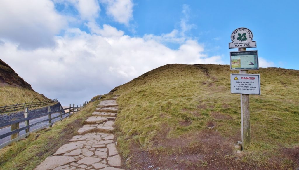
Hollins Cross has numerous paths leading in all directions. But you need to continue straight on the flagstoned path now heading uphill. You’ll go through two wooden gates then eventually it brings you out at Mam Tor summit, marked with a trig point.
On windy days you might see paragliders flying around Mam Tor summit, which is pretty spectacular.
More peak district shorts walks here
Stage 4 – Mam Tor to Castleton
Distance: 2.5 miles/4 km
Grid reference SK 12776 83600
Now you’ve done all the hard work, from Mam Tor trig, continue walking over the summit and on the stone footpath down the other side. Walk down the steps & bear left until you reach a gate (next to the sign for Mam Tor). Go through, down some steps on your left and through a second gate continuing down the grassy path.
Once through the gate, cross the road, then go through the gate almost opposite (slightly left). Walk on the path to the next road, cross over & continue on the footpath to Winnats Head Farm.
As you reach the farm go through the gate and take the path that leads to Treak Caverns, follow the path to where the road meets Winnats Pass and again cross over to take the pass that loops back to Castleton.
Cross over and take the footpath on your right that loops back to Castleton.If you prefer you can stay on the road for a slightly quick walk back, but the loop is a prettier option! . The path brings you past the houses in Castleton village, continue walking & you’ll be back out on the main road.

Buy a printable/downloadable PDF route guide for the walk here.
Do you have any more questions about this Lose Hill and Mam Tor walk, maybe what to wear on your hike or any other questions? Ask me in the comments below.
Buy a printable/downloadable PDF route guide for the walk here.
Other walk options
Looking for some shorter walks? You might like these walks from Castleton and nearby Barber Booth and Edale.
- Lose Hill Short Walk from Castleton | 5-mile Route
- Mam Tor Short Walk From Castleton | 5-Mile Route
- Rushup Edge Short Walk From Barber Booth | 5-Mile Route
- Grindslow Knoll (via Grindsbrook Clough) Short Walk from Edale | 4-Mile Route
Check out all our Peak District walking routes here
Save me to your Hiking boards on Pinterest


*Peak District Walks participates in the Amazon Services Associates Programme, as well as other affiliate programmes. If you purchase through these, Peak District Walks earn from the qualifying links. This is at no extra cost to you. Read more here.
Peak District Walks is a FREE online resource. Are you enjoying the walks? You can say thank you and buy me a coffee here. Thank you very much 🙂
Peak District charity patches
Read about the charity here.
Charity Patches

Charity Patches

Charity Patches

Charity Patches

Charity Patches

Charity Patches
Need more help planning your Peak District trip?
Join our Peak District walks Facebook page, follow us on Instagram and Twitter for inspiration.
More information on the Peak District, including transport options, where to stay, best Peak District pubs + other useful resources.
Check out the 7 YHAs in the Peak District and find the best walks direct from your accommodation.
Find out what maps you will need for your trip here.
Top tips - Read our useful guides on hiking tips here.
Guided Walks with an introduction to map reading (see dates here).
Visit our hiking recommendations page, (footwear, clothes + kit).
Or get in touch and I will help as best I can :).
Please note 'Peak District Walks' accepts no liability for any injuries or accidents resulting from walking our routes. We always recommend you wear appropriate footwear to avoid injuries and to take a paper map and compass on your walks. Read more here.
Pingback: Crowden Clough Scramble (Via Grindslow Knoll) From Barber Booth | 6-Mile Route - Peak District Walks
Pingback: Kinder Scout Walk From Edale (via Grindsbrook Clough) | 8-Mile Route - Peak District Walks
Pingback: Cave Dale Short Walk From Castleton | 2-Mile Route - Peak District Walks
Pingback: Lose Hill + Win Hill Circular Walk From Edale | 12-Mile Route - Peak District Walks
Pingback: Cave Dale Walk (+ Mam Tor) From Castleton | 5-Mile Route - Peak District Walks
Pingback: Win Hill + Crook Hill Walk From Ladybower Reservoir | 9-Mile Route - Peak District Walks
Pingback: Derwent Edge Circular Walk (via Lost Lad + Back Tor) | 8-Mile Route - Peak District Walks
Pingback: Edale Skyline Route | 20-Mile Route (Ultimate Peak District Challenge) - Peak District Walks
Pingback: Baslow Edge + Gardom's Edge Walk From Baslow | 7-Mile Route - Peak District Walks
Pingback: The Roaches Walk + Hen Cloud From Upper Hulme | 7-Mile Route - Peak District Walks
Pingback: 12 BEST Walks in the Peak District - Peak District Walks
Pingback: Lose Hill Short Walk from Castleton | 5-mile Route - Peak District Walks
Pingback: 8 Best Christmas Day + Boxing Day Winter Walks in the Peak District – Peak District Walks
Pingback: Hiking Tips – A Guide to Solo Hiking – Peak District Walks