Having reduced mobility, being in a wheelchair, or pushing a pushchair shouldn’t exclude anyone from enjoying the beautiful Peak District landscape. The Act of Parliament passed to establish National Parks spoke of providing recreational opportunities for the public, and that should mean all members of the public. Rocky paths, peat bogs, steep gradients and stone walls can all reduce easy access. We’ve compiled a list of wheelchair and pushchair friendly walks for everyone to enjoy. We’ll be adding to the list as we discover new routes.
Let us know in the comments if you’ve got any wheelchair and pushchair friendly walks we should include on the list!
Peak District Wheelchair and Pushchair Accessible Walks
We know accessibility is different for everyone. Below we have tried to give the clearest information possible about parking, access and footpath surfaces, to help you choose a Peak District walk route which is right for you.
Walk 1 – Lathkill Dale from Conksbury Bridge
Start Point: Conksbury Bridge, Back Lane, Bakewell, DE45 1JW. Grid reference: SK 2119 6565. Google Maps.
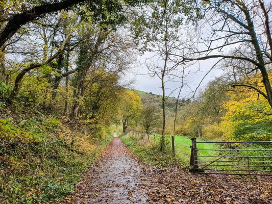
Lathkill Dale and the River Lathkill are incredibly pretty and this walk is a lovely opportunity to stop and enjoy watching the river and its wildlife. Conksbury Bridge is a medieval structure, named for the deserted medieval settlement of Conksbury, which was documented in the Domesday Book. The earthwork remains of the village are on the plateau on the other side of the river.
The small parking area close to Conksbury Bridge is reserved for Blue Badge holders. Further roadside parking can be found up the steep hill towards Bakewell.
The disabled parking area has a reasonably smooth surface. Go through the gate beside the parking area for ramped access to just over 500m of well compacted limestone pathway. There is a second gate part way through the route. Once you reach the end of the compacted surface you turn to head back to your car the way you came.
Walk 2 – Tideswell Dale

Start Point: Tideswell Dale Car Park, B6049, Buxton SK17 8QH. Grid reference: SK 154742. Google Maps.
This route, through pretty Tideswell Dale was registered as the first BT Millenium Mile in a rural landscape. Meaning it meets the BT Countryside For All standards of accessibility.
The Pay and Display car park is free to Blue Badge Holders and there are two parking spaces reserved for people with disabilities. The car park surface is compacted limestone, with paving slabs around the toilet block. A RADAR key is needed to access the toilet reserved for people with disabilities.
Follow the path to the right of the toilet block to access the dale. For the first 500m you are following a wide, tarmacked path. As you approach a wooden bridge over the stream you’ll see the path divides. You can take either route and it will take you on an approximately 300m circuit back to the bridge. This part of the path is made of compacted limestone. The left fork has a 2m ramp down of 1:12. The right hand fork has a 15mm step off the bridge then a 5m ramp down with a gradient of 1:12.
There are obvious additional options to extend the route depending on accessibility needs.
Once you’ve finished exploring the dale you can return the way you came to the car park. You will find various picnic tables and benches in the car park and along the route, allowing for places to rest and enjoy a bite to eat and a cuppa!
Walk 3 – Dovestone Reservoir
Start Point: Bank Ln, Greenfield, Oldham OL3 7NE. Grid reference: SE 013 036. Google Maps.
From the car park you can access a path leading all the way around the reservoir. The full circuit is just over 2.5 miles and although mostly level, there are some steeper gradients in places, there is a shorter out-and-back option which miss these out. Most of the pathway around the reservoir is stone finished but the steeper areas are tarmac.
The reservoir itself is managed in partnership with the RSPB and is popular with bird watchers. It offers beautiful views of the surrounding moorland and hills.
The car park is pay and display but free to blue badge holders, with reserved spaces. A RADAR key is needed for the toilet designed for those with disabilities
Set off from the car park in an anti-clockwise direction (this direction is better for the gradients), passing the sailing club. Head along the road, continue through a gate and along the road to where the streams meet. There is a steep section here, so some people may want to turn back, heading back to the car park and to explore the dam wall.
If choosing to continue, or if you would like more information on the gradients visit the Accessible Derbyshire page for Dove Stone here. For a route map visit the Peak District National Park’s Miles of Stiles page.
There are some picnic tables on level grass at Ashway Gap, about halfway round the reservoir circuit. If you choose to stop and enjoy the views make sure you look out for the stunning Peregrine Falcons which nest in the area.
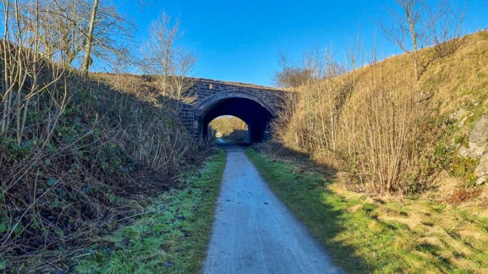
Walk 4 – Tissington and High Peak Trails from Parsley Hay
Start Point: Parsley Hay Car Park, off the A515, Buxton, SK17 ODG. Grid reference: SK1468 6371. Google Maps.
The Tissington Trail follows the route of the old London and North Western Railway (LNWR) which ran between Buxton and Ashbourne. With the trains now long gone its 13 mile length is is now a trail open to hikers, cyclists and horse riders. From your start point at Parsley Hay Car Park you can hire a variety of powered and non-powered bikes, mobility vehicles and accessible bikes. If you want to guarantee availability you can learn more and pre-book here.
From the car park you can turn right along the High Peak Trail towards Buxton. Alternatively, turning left gives you the option of following the High Peak Trail in the other direction, or taking the right hand fork onto the Tissington Trail, towards Ashbourne. All three options are steeped in the industrial history of the area, whilst offering views of the lovely surrounding countryside. You can find a map of the trails here and there are information points at Parlsey Hay for you to learn more.
Whichever route you choose you can travel along it for as far as you enjoy, before turning to return to your start point. Further information about accessibility at Parsley Hay can be found here.
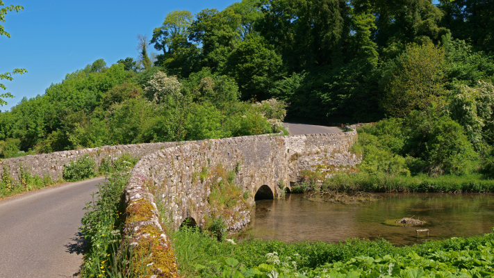
Walk 5 – Weag’s Bridge to Wetton Mill
Start Point: Weag’s Bridge, Larkstone Ln, Leek ST13 7TX. Grid reference: SK 09996 54239 Google Maps.
Alternative Start Point: Wetton Mill, Dale farm, Ashbourne DE6 2AG. Grid reference: SK 09553 56105. Google Maps.
This route follows the Manifold Way with scenic views of the River Manifold, which gained its name from its many turns or ‘folds’. The Manifold Way was converted from an old railway line and is relatively level and suitable for wheelchairs and pushchairs, as well as walkers, cyclists and horse riders.
The entire length of the way is 8 miles but this route takes you on an out-and-back journey of around 3.5 miles. We are describing it starting from Weag’s Bridge but you can also park and start from Wetton Mill. We have chosen it this way as you get the option to stop for refreshments at the tea rooms at Wetton Mill in the middle!
Both parking options offer fairly level, solid surfaces but neither have designated disabled spaces.
From Weag’s Bridge parking area, follow the track which runs through the parking area away from Weag’s Bridge, past a gate and onto the traffic-free Manifold Way. Continue following the winding path along the valley, with views of magnificent Thor’s Cave above and the meandering river below. After around 1.7 miles you will reach Wetton Mill. Here you will find a tea room with toilets where you can stop to refuel before retracing your journey to the start.
You can find a route map here.
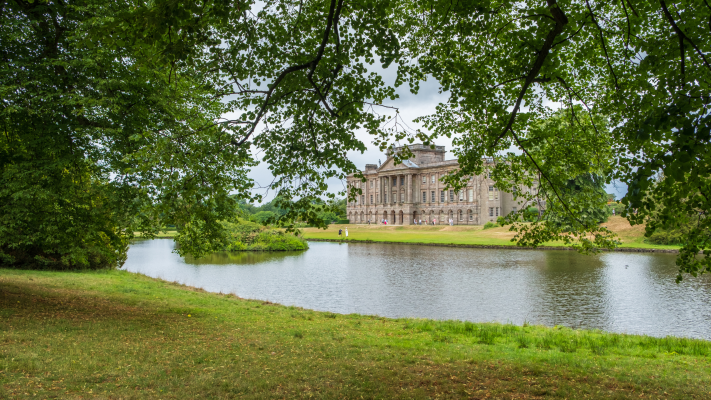
Walk 6 – Lyme Park Mill Pond
Start Point: Disley, Stockport, Cheshire, SK12 2NR. Grid reference: SJ 9629 8237 Google Maps.
Lyme Park is sits at the edge of the Peak District, in Cheshire. It is a grand stately home, sitting in a 1,400 acre estate and run by the National Trust.
There are charges for visiting both the house and gardens. Accessible parking is available, with level-access toilets and an accessible toilet in the Timber Yard. A step-free pathway leads up to the north front of the house from the car park. Wheelchairs and shuttle buggy/minibus available. For more information on charges and accessibility click here.
The route around the Mill Pond is around 1km in length with a wide, level and compacted path. The National Trust also has Tramper all-terrain mobility vehicles available for free hire. They recommend you do book these in advance to ensure availability.
Start this trail from the car park by Lyme Hall. The Grade I listed mansion house is the largest in Cheshire and was built in the 16th century and changed by Giacomo Leoni in the 18th century. Follow the path through the woods and around the pond, passing a cafe at the northern end before returning to the car park.
Did we mention that the BBC version of Pride and Prejudice was filmed here? In an infamous scene, Colin Firth, playing Mr Darcy, emerged from the lake. He and Elizabeth Bennet are also filmed strolling the gardens as their romance sets hold. The filming transformed the fortunes of Lyme Park and people still visit today to spot where scenes were filmed.
Walk 7 – Damflask Reservoir

Start Point: The Sands, Low Bradfield, Sheffield, S6 6LA. Grid reference: SK 26224 92022 Google Maps.
This 4-mile route takes you alongside Damflask Reservoir for an easy circular walk up to the top and around so you complete a full loop. This route is already written up on our website, so you can find full information including on parking and the start point here.
The route is mostly flat with a few small inclines and declines on the path around the reservoir. The terrain is not a sealed path so there is some loose gravel and mud in places; however, if you have a suitable pushchair or wheelchair this route would be great for you as there are no stiles and it is relatively easy terrain.
Damflask Reservoir sits on the site of site of the old Damflask village, which was washed away in the Great Sheffield Flood of March 11th 1864. The village was located where the dam wall is now and had various shops and dwellings, including a pub and blacksmith’s shop. The village had already been earmarked to be the site of the new reservoir before the flood, so it wasn’t rebuilt.
Read the whole walk description here.
Walk 8 – Longshaw Estate

Start Point: Woodcroft Car Park, Longshaw Estate, Grindleford, Sheffield S11 7TZ. Grid reference: SK 2668 8009 Google Maps.
The Longshaw Estate is run by the National Trust and their website has detailed accessibility information. The car park has a mixture of chipped tarmac and a hard-bound gritstone surface, with permeable plastic paving grids under parking bays.
There are 15 designated disabled/young family extra-wide spaces available within the Woodcroft car park. They are approximately 250m from the café and 60m from the Moorland Discovery Centre. Parking is free for National Trust members and blue badge holders.
There are two options for accessible routes, with a map and details available on the Peak District National Park website here. One route takes you to the tranquil fishpond, where you can sit and enjoy the view. An alternative route, of up to 1.3km, leads you past the ice house and through the woods.
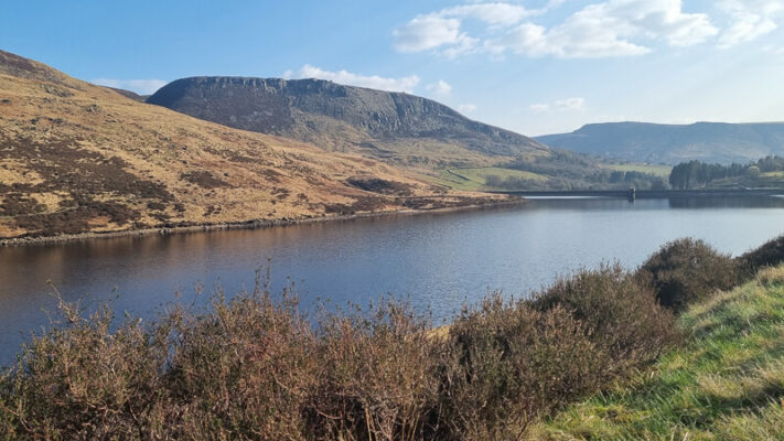
Walk 9 – Ladybower Reservoir

Start point: Heatherdene car park, Ladybower Reservoir, Hope Valley, S33 0BY. Grid reference SK 2023 8588 Google location
Ladybower Reservoir was constructed in the 1930’s-1940’s, with the flooding of the villages of Derwent and Ashopton meaning residents had to move to nearby areas. The remains of the village can still be seen when the water level is very low. The reservoir sits in a valley, giving you stunning views of the surrounding hills.
The Heatherdene car park at Ladybower is pay-and-display with 70 spaces, 9 of which are dedicated accessible parking spaces. There is level access from the main car park to the accessible toilet and picnic area. You can find more information about accessibility about Heatherdene and the nearby area here.
From the car park there are two route options, depending on levels of accessibility needs. The first takes you along a tarmac path to drop down for views of the dam on a walk of around 400m. The second takes you along a path into surrounding woodland, for a route of up to 3km.
There are Trampers for hire at nearby Derwent Bike Hire Centre.
If you want to add an extra adventure to your day why not go on a Wheelyboat trip from nearby Ladybower Fisheries? You can find out about contacting them and booking a boat trip here.
Walk 10 – Goyts Lane and the Goyt Valley
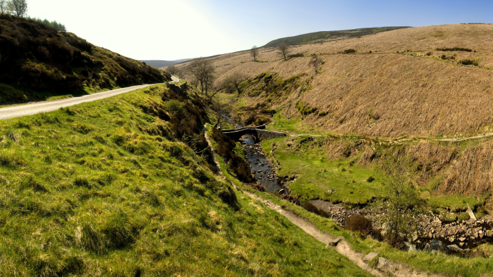
Start point: Car park at Goyt’s Lane, via the A5004 north-west of Buxton. Grid reference SK 0232 7515 Google location
The beautiful Goyt Valley was once the site of the Cromford and High Peak Railway. You can now follow the old railway line into the Goyt Valley on an out and back trip of around 2km to an embankment with elevated views of the surrounding valley.
The starting point is a small car park, about half a mile down from the A5004 Buxton to Whaley Bridge road. Follow the sign to Goyt Valley and you the car park is on the left, alongside a small reservoir. There is additional parking on the other side of the road. Both parking areas have fairly level, compacted stone surfaces. There are no toilets at these car parks.
The reservoir beside the car park once provided water to the steam-driven pulleys which pulled trains up and down the Bunsall Incline. It used to freeze so well in Victorian times that people would ice skate on it.
By the other side of the reservoir from the car park you will see a field gate. Pass to the left of this to continue along a track by the reservoir. This track leads you for about 1km to a lone tree on the embankment, where you can rest before returning to your start point.
For a map of the route click here.
If you’d like to know much more about the Goyt Valley visit this lovely website with lots of detail of its history, which also includes more walks.
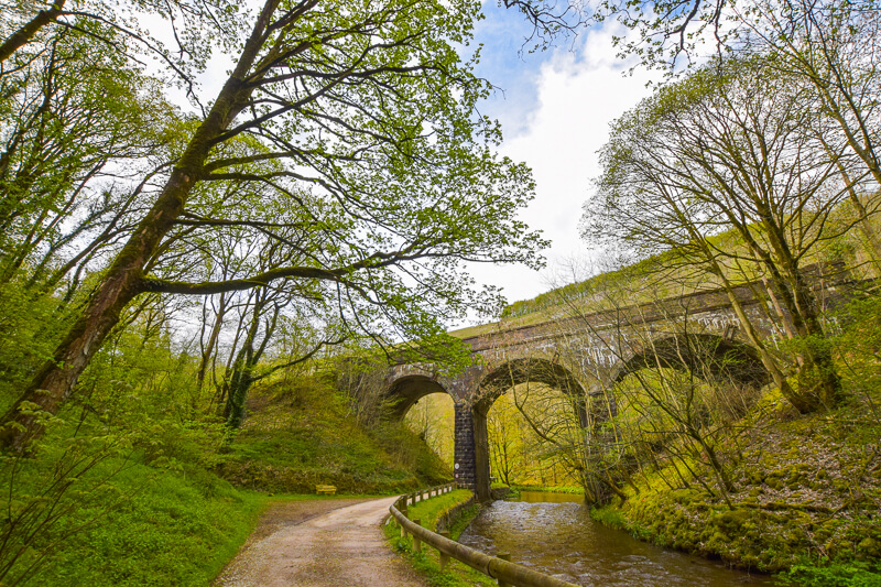
Walk 11 – Monsal Trail
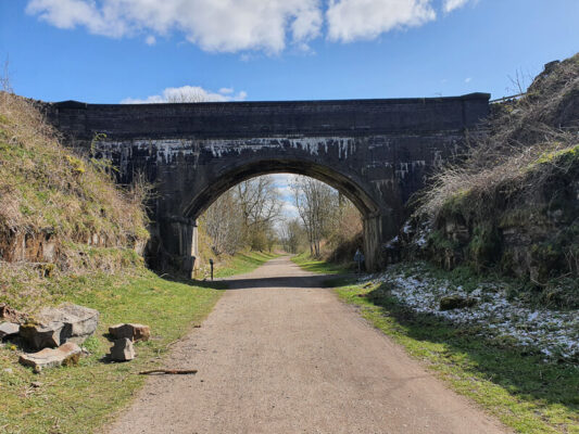
The Monsal Trail is a 8.5-mile traffic free route, which follows the former Manchester to London Midland Railway line. Its compacted surface means it’s ideal for walkers, cyclists, horse riders and wheelchair users.
There are various access points along the trail and old stations at Bakewell, Hassop and Millers Dale have pay and display car parks offering easy access onto the Trail.
The disused railway station at Hassop has a café, book and gift shop and cycle hire, including accessible cycles. It’s totally wheelchair accessible, making it a great place to start and end a walk. Millers Dale also has a cafe and a full Changing Places Toilet (CPT) facility, which can be accessed directly from the car park area.
You can find a range of walking route ideas and further information in our 9 Monsal Trail Walks in the Peak District article.
For more information on the Monsal Trail and its facilities visit the Monsal Trail page on the Peak District National Park website.
Do you have any more questions about these wheelchair and pushchair accessible routes? Ask me in the comments below.
Ordnance Survey Walk Maps
For these walks, there are two maps that cover them OL1 – Peak District (Dark Peak Area) and OL24 – Peak District (White Peak Area)
Shop online at Ordnance Survey
And don’t forget your compass, I recommend the Silva Expedition or the Silva Classic compass.
For online maps, I recommend the OS Online App (I have been using it for many years and it is worth getting if you want to start walking more). Check prices here for the one-month or annual option with the OS Online App. All the walks on the website are created using OS Online + you can download them to the App.
Check prices here for the one month or yearly option with OS Online App.
More walks in the Peak District
For lots more accesible walking route options we recommend visiting the Peak District National Park’s Miles Without Stiles.
Or check out all our Peak District walking routes here
*Peak District Walks participates in the Amazon Services Associates Programme, as well as other affiliate programmes. If you purchase through these, Peak District Walks earn from the qualifying links. This is at no extra cost to you. Read more here.
Peak District Walks is a FREE online resource. Are you enjoying the walks? You can say thank you and buy me a coffee here. Thank you very much 🙂
Peak District charity patches
Read about the charity here.


Charity Patches

Charity Patches

Charity Patches

Charity Patches

Charity Patches

Charity Patches
Need more help planning your Peak District trip?
Join our Peak District walks Facebook page, follow us on Instagram and Twitter for inspiration.
More information on the Peak District, including transport options, where to stay, best Peak District pubs + other useful resources.
Check out the 7 YHAs in the Peak District and find the best walks direct from your accommodation.
Find out what maps you will need for your trip here.
Top tips - Read our useful guides on hiking tips here.
Guided Walks with an introduction to map reading (see dates here).
Visit our hiking recommendations page, (footwear, clothes + kit).
Or get in touch and I will help as best I can :).
Please note 'Peak District Walks' accepts no liability for any injuries or accidents resulting from walking our routes. We always recommend you wear appropriate footwear to avoid injuries and to take a paper map and compass on your walks. Read more here.