
Most people’s first experience of Winnats Pass will be driving through the pass via the road. It really is one of those wow moments and if you’re lucky to be the passenger you can really take it all in!
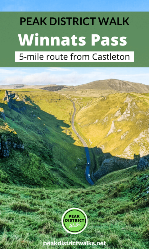
This walk takes you above Winnats Pass and the views are amazing. The route starts in nearby Castleton, a popular place to start many different walks and from there it takes you up a steep and rocky path to Winnats Pass.
It’s a challenging hike, so read the ‘other useful information’ section to be sure this walk is for you.
After walking along Winnats Pass you descend down to the road then across and back uphill to the wonderful Mam Tor, with even more great views.
This is a tough walk but it really has some of the best views for a short route.
Here you will find details on how to get to the start of the walk from Castleton, route information, GPX file, facilities on the walk, plus a detailed step by step guide of the walk.
WARNING: We received information in July 2026 that the fencing at the fence over the gully at the top of the pass has half fallen over, meaning you would need to crawl under it. The rope to help you up is also no longer there. You would need to be confident at scrambling to attempt this walk currently (even in good weather).
We will be looking at alternative route options for this route soon. In the meantime, please always stay safe and within your abilities.
Do you have any more questions about this route? Ask me in the comments.
Buy a printable/downloadable PDF route guide for the walk here.
Winnats Pass + Mam Tor walk from Castleton

Walk information + GPX
Walk type: Short circular walk
Distance: 5 miles/8 km
Walk time: 2.5-3 hours
Total ascent: 409 m/1,342 ft
Highest point: 517 m/1,696 ft
Walk highlights: Views from Winnats Pass, summiting Mam Tor and views of the Hope Valley from the Great Ridge to Hollins Cross
Trigs: 1 – Mam Tor
Ethels: 1 – Mam Tor
Winnats Pass + Mam Tor walk map

© Crown copyright and database rights (2024) OS 002572460
Walk start point
Start grid reference: SK 14936 82940
Car parking address: Castleton Visitor Centre, Buxton Road, Castleton, S33 8WN
There are plenty of car parking spaces at the visitor centre, but Castleton is this is a popular place for hiking so spaces can fill up if you don’t arrive early. There’s an additional car park further down the road if this one is full.

Parking Cost*
Up to 1 hour £1.60
1-2 hours £2.50
2-4 hours £4.00
4-10 hours £6.00
*Prices correct at time of writing
Public transport
Nearest train station: Hope train station (1 mile/2 km)
Facilities on the walk
There are public toilets available next to Castleton Visitor Centre. You can also pick up breakfast (if you start your hike later, as the cafe doesn’t open until 10 am) and snacks for your hike.
There are also other shops and cafes in Castleton village, that you can treat yourself to goodies either before or after the walk. There are several pubs for that after walk drink. The Castle pub is one of my favourites.
There are no further shops or additional toilet facilities on this walk.
Water on your walk – I recommend a filter water bottle for your Peak District walks, it saves you from carrying extra weight and you can fill up safely and drink water from the streams on your walk.
Other useful information
WARNING: We received information in July 2026 that the fencing at the fence over the gully at the top of the pass has half fallen over, meaning you would need to crawl under it. The rope to help you up is also no longer there. You would need to be confident at scrambling to attempt this walk currently (even in good weather).
We will be looking at alternative route options for this route soon. In the meantime, please always stay safe and within your abilities.
The hike up to Winnats Pass is particularly steep, in fact, you may need to use your hands and scramble up some sections. Also, if it’s wet weather, then the path will be really slippy. It’s not a route I would recommend if you are hiking with children.
The section walking along Winnats Pass is a steep cliff, and there are sheer drops along sections of the path down to the road.
You can get some beautiful skies at sunrise and sunset as Winnats Pass runs east to west so works perfectly for a good photo.
Not sure this route is for you? Here are 9 more options for hiking up Mam Tor in Derbyshire
Check the weather for your walk location and hills. We’d recommend that you check a few resources and for hill walks look at the weather conditions in the valley and on the hilltop as they can greatly vary.
- BBC Weather for Castleton
- Met Office weather and/or MWIS (Mountain weather information service) for the Peak District
- Met Office weather for Mam Tor
Mam Tor patch
Why not celebrate reaching the top of Mam Tor with our very first charity patch? Or if you are planning on doing the walk soon, order the patch now so you can take it to the top for a photo. visit shop

Charity Patches
Ordnance Survey Walk Map
The map for this walk is the Ordnance Survey OL1 – Peak District (Dark Peak Area).
View the different prices here with Ordnance Survey or Amazon. If you’re hiking in all weather the Active OS maps are good to have as they are laminated so better on rainy days.
View both Peak District map options here.
And don’t forget your compass, I recommend the Silva Expedition or the Silva Classic compass.
For online maps, I recommend OS Online App (I have been using it for many years and it is worth getting if you want to start walking more). Check prices here for the one-month or annual option with OS Online App. All the walks on the website are created using OS Online + you can download them to the App.
See both maps that cover the Peak District here.
Want to learn more map skills? Check out our Guided Walks with map reading skills here.

Check prices here for the one month or yearly option with OS Online App.
Want to read later? Save the walk to Pinterest
Winnats Pass + Mam Tor walk route
Stage 1 – Castleton village to Winnats Pass
Distance: 1 miles/1.6 km
Grid reference SK 14919 82956
Turn right out of Castleton Visitor Centre, and walk down the road for about 200 metres, crossing the road at the car park where you’ll see a sign.
Turn left through the car park then take the road bearing right heading uphill.
Continue until you reach a gate that takes you to a single track path alongside a wall. From here, you’ll be able to see the Great Ridge and Mam Tor on your right and Winnats Pass in front of you.
Walk along the path until you reach a second gate. Here you can see a rough trail heading steeply up to the top. (If at this point you decide this route isn’t for you, you can bypass this section of the walk and opt to walk through Winnats Pass next to the road.)

Hike up with the boundary fence on your left, there are some sections where a rope has been tied on a gate post. You can use this as an aid to hike up this section (unless you feel it’s no longer safe).
Follow the narrow rocky gully all the way to the top, where you will reach the grassy section of Long Cliff. Keep close to the boundary wall and walk until you reach the start of Winnats Pass.
Stage 2 – Winnats Pass to Mam Tor
Distance: 1.4 mile/2.3 km
Grid reference SK 13804 82520
As you walk along Winnats Pass, there is a boundary fence where you can see the trail goes along. You can explore a little closer to the edge, but as mentioned previously, it’s a sheer drop so please be careful near the edge, especially when the weather is bad.

If you have time to stop and enjoy the views it’s worth taking a rest along this section, watching the tiny cars wind their way through Winnats Pass and then admiring the views in the distance.
At the end of Winnats Pass, there’s another steep descent down to the road, not quite as steep as before, but still steep enough to take it slow!
Cross over the road and go through the gate on the other side.
Bear left on the footpath, crossing two roads, as you head towards Mam Tor, which you should be able to see on a clear day. Then up a final grassy bank that takes you to the bottom of Mam Tor.
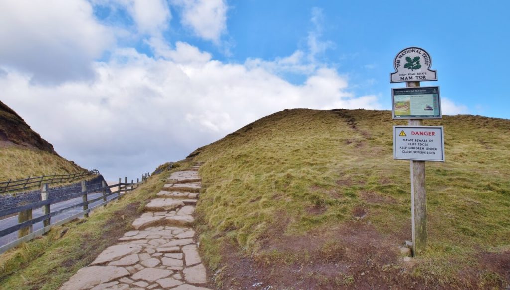
At the gate at the top, you’ll see a sign for Mam Tor and from here you take the stone path up to Mam Tor summit, marked with a trig point.
Stage 3 – Mam Tor to Castleton
Distance: 1.9 mile/3 km
Grid reference SK 12776 83600
From Mam Tor summit, you now continue along the path descending along the Great Ridge, there are beautiful views to the valleys each side so another lovely part of the walk.

Continue all the way to Hollins Cross, a large stone marker. Go through the gate then take the right-hand path that heads downhill back in the direction of Mam Tor.
This is a narrow path which eventually brings you out on the old road that is no longer in use due to subsidence in the area. Walk down the road, then after 300 metres look for a footpath on the left near some old millstones.
This footpath takes you through a small wooded section, across a little wooden bridge then back via fields to Castleton village and out onto the main road. Turn left and you are back at the visitor centre.
Do you have any more questions about this walk, ask me in the comments below?
Buy a printable/downloadable PDF route guide for the walk here.
More walk options
Looking for some more walks that are a bit different? You might like these walks:
- Kinder Scout Walk From Edale (via Grindsbrook Clough) | 8-Mile Route
- Chee Dale Walk From Miller Dale | 5-Mile Route
- Grindslow Knoll (via Grindsbrook Clough) Short Walk from Edale | 4-Mile Route
Check out all our Peak District walking routes here
Save me to your Hiking boards on Pinterest


*Peak District Walks participates in the Amazon Services Associates Programme, as well as other affiliate programmes. If you purchase through these, Peak District Walks earn from the qualifying links. This is at no extra cost to you. Read more here.
Peak District Walks is a FREE online resource. Are you enjoying the walks? You can say thank you and buy me a coffee here. Thank you very much 🙂
Peak District charity patches
Read about the charity here.
Charity Patches

Charity Patches

Charity Patches

Charity Patches

Charity Patches

Charity Patches
Need more help planning your Peak District trip?
Join our Peak District walks Facebook page, follow us on Instagram and Twitter for inspiration.
More information on the Peak District, including transport options, where to stay, best Peak District pubs + other useful resources.
Check out the 7 YHAs in the Peak District and find the best walks direct from your accommodation.
Find out what maps you will need for your trip here.
Top tips - Read our useful guides on hiking tips here.
Guided Walks with an introduction to map reading (see dates here).
Visit our hiking recommendations page, (footwear, clothes + kit).
Or get in touch and I will help as best I can :).
Please note 'Peak District Walks' accepts no liability for any injuries or accidents resulting from walking our routes. We always recommend you wear appropriate footwear to avoid injuries and to take a paper map and compass on your walks. Read more here.
Pingback: 8 Best Walks From Edale in the Peak District | (Plus Maps + GPX) - Peak District Walks
Pingback: Cave Dale Walk (+ Mam Tor) From Castleton | 5-Mile Route - Peak District Walks
Pingback: 10 Mam Tor Walks in the Peak District (Short, Medium + Long Walking Routes) - Peak District Walks
Pingback: 7 Fun Peak District Scrambles + BEST Routes - Peak District Walks
Pingback: Ringing Roger Short Walk From Edale | 4-Mile Route – Peak District Walks