A walk including three of the awesome Peak District edges, each with their own fantastic views.
This route begins from Heatherdene car park near Ladybower Reservoir, you first have the beautiful Bamford Edge to hike up, then it’s on to Stanage Edge and finally you get to explore the far side of Derwent Edge before heading back down for maybe some refreshments at one of the two pubs nearby.
Here you will find details on how to get to the start of the walk at Ladybower Reservoir, plus options for parking, route information, map, GPX file, plus a detailed step by step guide of the walk.
Let me know in the comments if you’ve walked any of these Peak District edges and what you think!
Bamford Edge, Stanage Edge, Derwent Edge from Ladybower Reservoir

Walk information
Walk type: Medium/long circular walk
Distance: 11.6 miles/18.6 km
Walk time: 6-7 hours
Total ascent: 678 m/2,224 ft
Highest point: 481 m/1,578 ft
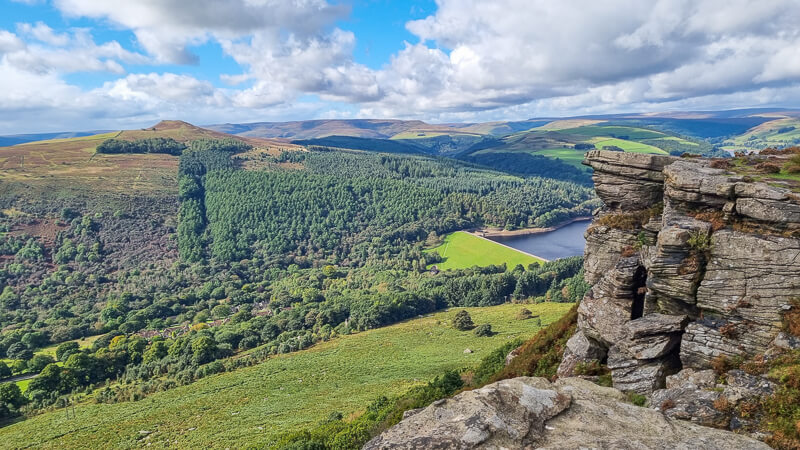
Walk highlights: Bamford Edge with views of Win Hill, Stanage Edge with a trig, Derwent Edge, The Wheel Stones and views of Ladybower Reservoir.
Trigs: 1 – High Neb (Stanage Edge)
Ethels: 1 – High Neb (Stanage Edge)
Stiles: 5
Bamford Edge, Stanage Edge + Derwent Edge walk map

Walk start point
Start grid reference: SK 202 859
The walk starts from the pay and display car park (£2.50 for up to 2 hours, £6 to park all day – cash and cards taken) at Ladybower Reservoir, which is medium/large size car park. Or alternatively you can start at Dennis Knoll car park, a small free car park with no facilities, this is further along the route.
Heatherdene car park, Ladybower Reservoir, Hope Valley, S33 0BY Google location

Option 2 – Dennis Knoll car park, Long Causeway, Bamford, Derbyshire, S32 1BQ- Google location (Located on Stage 2 route instructions).
Facilities on the walk
There are public toilets available at the start of the walk at Heatherdene car park near Ladybower Reservoir.
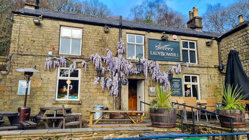
There are two pubs that near the end on the route (one just before and one just after) – The Ladybower Inn and The Yorkshire Bridge.
Other useful information
Bamford Edge can be a popular place to visit so it’s worth starting your walk early so you can enjoy the views to yourself (if you prefer having places to yourlself).
Also the section after the road crossing from Stanage Edge can be very muddy and boggy in places, this is only a short part of the walk but worth wearing waterproof footwear.
Please keep the Peak District beautiful and respect everyone who uses the park. Take ALL your rubbish home to dispose of and remember close gates (as you found them). Thank you so much.
Would you know what to do in an emergency situation?

We have a guide with what to do, who you need to call and also some useful kit that should be in your backpack. Ask us any questions in the comments or via our social media.
Happy hiking + stay safe
read herePeak District weather
Check the weather for your walk location and hills. It’s often good to check a few resources.
- BBC Weather for Bamford
- Met Office weather for High Neb on Stanage Edge
- Met Office weather and/or MWIS (Mountain weather information service) for the Peak District
Ordnance Survey walk map
The map for this walk is the Ordnance Survey OL1 – Peak District (Dark Peak Area). Check prices here with Ordnance Survey or Amazon. If you’re hiking in all weathers the Active OS maps are good to have.
View both Peak District map options here.
And don’t forget your compass, I recommend the Silva Expedition or the Silva Classic compass.
For online maps, I recommend OS Online App (I have been using for 4+ years and worth getting if you want to start walking more). Check prices here for the one month or yearly option with OS Online App. All the walks on the website are created using OS Online + you can download them to the App.
See both maps that cover the Peak District here.
Bamford Edge patch
Bamford Edge is a stunning viewpoint in the Peak District.
Our patch captures the view from Bamford Edge looking towards Ladybower Reservoir. Order your patch below.
visit shop

Charity Patches
Bamford Edge, Stanage Edge + Derwent Edge route
Stage 1 – Ladybower Reservoir to Bamford Edge
Distance: 1.6 miles/2.6 km
Grid reference SK 202 859
From Heatherdene car park walk towards the toilet block to the right of the main parking area. Go down the wide path (photo below) that runs parallel to the road which is beneath through the trees. At the path junction, turn left here, heading away from Ladybower Reservoir. Walk straight uphill through the woods.

Continue uphill, across a small wooden bridge then over a wooden stile over a fence next to a stone wall. Walk alongside the wall continuing to head uphill, you’ll go through some trees then through a gap in the wall. Finally you’ll reach a path towards the top, turn right here and follow this all the way along for about 1 km until you reach Bamford Edge.

Stage 2 – Bamford Edge to Stanage Edge (High Neb)
Distance: 3.5 miles/5.7 km
Grid reference SK 2073 8495
Once you’ve explored the area around Bamford Edge continue in the same direction, following the footpath as it bears round to the left and alongside the edge heading southeast, then take the path heading downhill towards New Road, where you’ll go over a stile to the road.
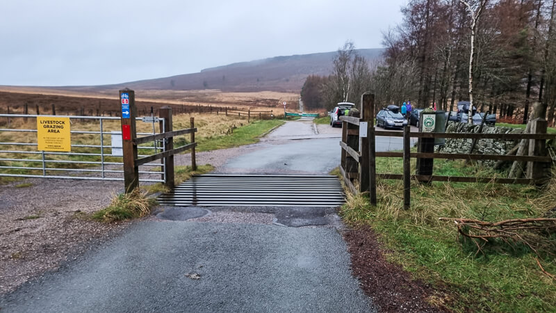
Turn left and now follow the road all the way to a cattle grid (photo below) that leads to Dennis Knoll car park (option to start the walk here if you’re driving).
Walk straight ahead, skirting round the green barrier. Follow this path as it bends around to the right and heads uphill towards Stanage Edge.
At the top of Stanage Edge take the rocky footpath heading left and walk along here where the path begins to widen. You’ll go over a wooden step stile and stay on Stanage Edge, the path can be muddy and wet in parts. After about 1.5 km you’ll reach High Neb trig point, also a Peak District Ethel, 458 m the highest point on Stanage Edge.

Stage 3 – Stanage Edge (High Neb) to Derwent Edge
Distance: 4 miles/6.5 km
Grid reference SK 2280 8534
From the trig point, after 1.5 km you reach the quarry area, take the path on the left picking up the Sheffield Country Walk. Go down the path, you’ll walk past the back of a green public footpath sign for Stanage Edge. Shortly after the sign, take the left hand path towards the road and go over a wooden stile.
Turn left and walk on the narrow grassy verge alongside the road, it’s the worst bit of the walk but it’s short. After 500 m, cross over and go down the side road on the right. Then turn left signposted ‘Public Footpath via Derwent Edge’.

Walk down the track past the house, then just before the metal barrier look for a wooden post on the left. Follow this rough footpath as crosses over the brook, you may need to jump to avoid wet feet!
At the path junction, make sure you’re on the right of the wall, walk round and you’ll see another green public footpath signpost. Turn left here and walk uphill via the track next to the wall heading under the pylons. Go over the wooden stile (or metal gate if it’s open). Walk up the track, it splits further up, stay on the right-hand track and keep heading up past a stone grouse butt. Then you’ll reach the main path for Derwent Edge.
An option is to turn right here and head up to the Wheelstones, about 500 m. These are fascinating to explore and make a great place to stop for a break.
Stage 4 – Derwent Edge to Ladybower Reservoir
Distance: 2.3 miles/3.7 km
Grid reference SK 2016 8853
Once you’ve explored the Wheelstones on Derwent Edge head back down the path, at the cairn with the green public footpath signpost keep walking straight on, there are some beautiful views of Ladybower Reservoir from here. Follow the path round the edge where you’ll reach another path junction with several paths.

Keep walking straight on (path in centre of photo above), over the next hill Lead Hill and then follow the footpath as it takes you down a rocky path towards Ladybower Reservoir. At the path at the bottom turn left and continue down, through a wooden gate then to the end of the path which turns sharply right down to the road (there’s a steep short cut if you prefer).

When you reach the road, turn right, past the Ladybower Inn, then turn left and go across the bridge on the pavement alongside Ladybower Reservoir. Walk down the pavement until you reach the entrance for Heatherdene car park on your left and you’re back at the start!
Ask me any questions about this walk from Ladybower Reservoir in the comments below.
More walk information
Shorten the walk
There aren’t many options to shorten this route but you can skip the out and back to the Wheel Stones on Derwent Edge but this will save you 1 km in distance.
More walks in the Peak District
Love the medium to long walks? You might like these Peak District circular walks.
- Baslow Walk (Including Froggatt Edge, Curbar Edge + Baslow Edge) | 11-Mile Route
- Lose Hill + Win Hill Circular Walk From Edale | 12-Mile Route
- Langsett Reservoir, Margery Hill + Outer Edge Trig From Langsett Barn | 13-Mile Route
Or check out all our Peak District walking routes here
Peak District Walks is a FREE online resource. Are you enjoying the walks? You can say thank you and buy me a coffee here. Thank you very much 🙂
Peak District charity patches
Read about the charity here.


Charity Patches

Charity Patches

Charity Patches

Charity Patches

Charity Patches

Charity Patches
Need more help planning your Peak District trip?
Join our Peak District walks Facebook page, follow us on Instagram and Twitter for inspiration.
More information on the Peak District, including transport options, where to stay, best Peak District pubs + other useful resources.
Check out the 7 YHAs in the Peak District and find the best walks direct from your accommodation.
Find out what maps you will need for your trip here.
Top tips - Read our useful guides on hiking tips here.
Guided Walks with an introduction to map reading (see dates here).
Visit our hiking recommendations page, (footwear, clothes + kit).
Or get in touch and I will help as best I can :).
Please note 'Peak District Walks' accepts no liability for any injuries or accidents resulting from walking our routes. We always recommend you wear appropriate footwear to avoid injuries and to take a paper map and compass on your walks. Read more here.
*Peak District Walks participates in the Amazon Services Associates Programme, as well as other affiliate programmes. If you purchase through these, Peak District Walks earn from the qualifying links. This is at no extra cost to you. Read more here.
Thank you for this – good walk! 🥾🥾
Ah you’re very welcome, really glad you enjoyed it – Becky 🙂