
This two trig walk takes in some of the best that the South Yorkshire corner of the Peak District has to offer. Starting from the popular Langsett Reservoir, the route takes in the famous Cut Gate Path up to the two trig pillars of Margery Hill and Outer Edge, along with an optional detour to the excellent Crow Stones.
From the Langsett Reservoir, you loop across the dam and around the water to join the Cut Gate Path up the high ridgeline of the Howden Moors. Then you can bag the first of two trigs; Margery Hill, which is also a Peak District Ethel. Then on to the trig at Outer Edge, whilst enjoying breathtaking views across the Upper Derwent Valley and the Dark Peak beyond.
An optional loop down Outer Edge brings you to the unique gritstone outcrop known as the Crow Stones, for more excellent views and opportunities to explore the rocks.
Dropping down off the northern edge of Howden Moor you cross the Little Don River and follow its northern banks as it winds back eastward to the woodland stores of the Langsett Reservoir to complete the circuit.
Here you will find details on how to get to the start of the walk at Langsett Barn, route information, map, GPX file, plus a detailed step by step guide of the walk.
Let me know in the comments if you’ve done this walk and what you think!
Langsett Reservoir + Margery Hill from Langsett Barn

Walk information
Walk type: Long circular walk
Distance: 12.6 miles/20.3 km
Walk time: 5-6 hours
Total ascent: 505 m/1,657 ft
Highest point: 546 m/1,791 ft
Walk highlights: Langsett Reservoir, Cut Gate Path, Margery Hill Trig, Outer Edge Trig, Views of the Upper Derwent Valley, Crow Stones
Trig points: 2 – Margery Hill and Outer Edge Trig
Ethels: 1 – Margery Hill
Stiles: 1
Langsett Reservoir + Margery Hill walk map
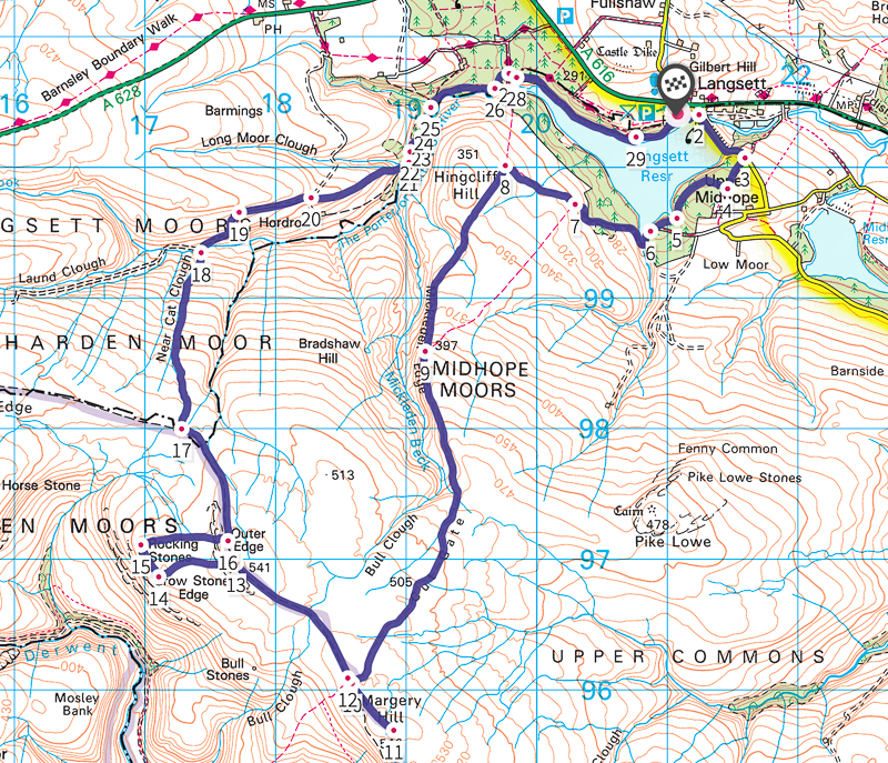
© Crown copyright and database rights (2024) OS 002572460
Walk start point
Start grid reference: SE 21042 00437
Car parking address: Langsett Barn car park, S36 4GY – Google link

Langsett Barn is a free car park, with approximately 80+ spaces. Additional free parking in the lay by off the A616 a few hundred metres west of the Langsett Barn parking. Please note during peak periods the car park and lay-by spaces can fill up quickly.
Public transport
Nearest train station: Sheffield train station (15 mile/25 km)
The number 407 bus runs along the A616 and stops at the Waggon & Horses pub next to the Reservoir.
Facilities on the walk
There are public toilets available at the start of the walk the Langsett Reservoir car park, including a picnic area at the Langsett Barn Outdoor Centre.
In addition, nearby to Langsett Barn there’s the Wagon & Horses pub and Bank View Cafe, both perfect for an after walk treat.
Other useful information

The areas along the high ground of Howden Moor are notoriously boggy and after heavy or prolonged rainfall in the winter months, much of the area becomes very muddy with sections of deep bogs.
Sturdy waterproof footwear with gaiters is recommended along with a careful and considered approach to all boggy sections.
- Rab Kangri GTX gaiter
- Rab Women’s Muztag GTX gaiter
- Trekmates Rannoch Moor gaiter
- Trekmates Cairngorm GTX gaiter
One short 200m section of the walk after the Langsett dam is on a small road without pavement, there is limited traffic however extra care should be taken in this area
Note: some areas of this path can be muddy after a rainfall.
The route has very limited signposts and it’s easy to get lost on the moors. I always recommend you take a map and compass (see below).
Peak District weather
Check the weather for your walk location and hills.
- BBC Weather for Langsett
- Met Office weather for the Peak District
- Met Office weather for Langsett Barn and/or MWIS (Mountain Weather Information Service) for the Peak District.
Ordnance Survey walk map
The map for this walk is the Ordnance Survey OL1 – Peak District (Dark Peak Area). Check prices here with Ordnance Survey or Amazon. If you’re hiking in all weathers the Active OS maps are good to have.
And don’t forget your compass, I recommend the Silva Expedition or the Silva Classic compass.
For online maps, I recommend the OS Online App (I have been using it for many years and it is worth getting if you want to start walking more). Check prices here for the one-month or annual option with the OS Online App. All the walks on the website are created using OS Online + you can download them to the App.
Margery Hill + Outer Edge from Langsett walk route
Stage 1 – Langsett Barn to Margery Hill
Distance: 5.2 miles/8.5 km
Grid reference SK 18907 95691
From the car park, take the exit in the southeast corner down the steps to the reservoir. Turn left towards the dam wall. Go through the gate and turn right across the dam to the other end where the path ends. Follow the road until the treeline on the right ends and turn right along the track.

After 280m, go through the gate into the woodland. At the fork take the right path down the to waters edge, continuing along the path as it tracks along the edge of the reservoir.
Continue walking then go through a metal gate at the edge of a small inlet into the reservoir. Turn right over the bridge, continuing up the path for 1.2 km.
The path breaks onto the edge of the moorland as you come to a wooden gate in a stone wall, go through the gate and continue straight for 650 m.

Cut Gate Path
The track meets the Cut Gate Path at a t-junction, turn left and continue upward onto Hingcliffe Common. After 1 km the path joins with Mickleden Clough and tracks along its eastern edge as you continue to climb up onto the high moors.
A further 1.6 km you reach the head of Mickleden Clough and begin to bear southwest towards Howden Edge, the following 1.8 km is easy enough to follow, but is interspersed with several boggy and eroded sections, all are passable with considered route planning.

Eventually, the path reaches the crossroads with the routes along Howden Edge, the junction is marked with a cairn.
To reach Margery Hill, turn left (southeast) and climb up onto the moorland path. There are two tracks here, take the left-hand one as it tracks across the moor to the left-hand side of the small fenced enclosure ahead. About 430 m from the cairn you’ll come to a stile* with the trig visible just beyond it. *We’ve been advised that this stile has collapsed, however, the fence is low and easy to negotiate.
Nestled amongst the Margery Stones, the trig has excellent views of the escarpment line of edges to the south along with Lose Hill and the Great Ridge.

Stage 2 – Margery Hill to Outer Edge
(with Crow Stones detour option)
Distance: 2.3 miles/3.8 km
Grid reference SK 17701 96969
From Margery Hill, retrace your steps to the northwest back to the Cut Gate cairn.
Cross back by the cairn and continue northwest towards the prominent high ground of Outer Edge that lies ahead. The first 1 km of this next 1.3 km section to the Outer Edge trig is the most heavily saturated, with several deep cloughs to cross as the path first drops down across the moor before climbing again towards the trigs position.

To navigate the deep bogs and cloughs, the path will often meander to circumvent them, once beyond each obstacle re-find the high ground ahead to the northwest to ensure you are on the correct bearing.
Eventually, you will be able to better see the path as it begins to climb upward out of the more heavily saturated ground, eventually leading to the Outer Edge trig point at its highest point.
From here you can see down the Upper Derwent Valley, with Howden Reservoir just visible, along with views across the wide rolling moorlands of Howden and Bleaklow Moors and the Kinder Plateau to the west.
Directly west on the edge of the moorland shelf below, you will see the Crow Stones, a series of prominent gritstone tors protruding up from the edge. From here you can drop down to the stones, but you can continue along the path to the north and pick up the route guidance in ‘Stage 3’.
Crow Stones (mini detour)

To reach the stones, a faint track can be seen heading west from the trig, follow this path towards the edge and carefully make your way down onto the shelf below.
The paths here are faint with small cloughs to cross, but with the ‘Crow Stones’ ahead keep following their bearing across the small moorland shelf until you arrive at the stones.
The collection of several large and varied gritstone tors provides an excellent stopping point for a break and exploration, with the views across the open valley to the west arguably the best of the day.
Turn back east from the stones towards the rocky escarpment of Outer Edge and follow the most northern track back towards it. Aim for a large rock that has a unique oval scallop (like a large eye), to the left of the path back up onto the edge to rejoin the route.
Stage 3 – Outer Edge to Langsett Barn
Distance: 5 miles/8 km
Grid reference SE 21042 00437
From the Outer Edge trig, or from rejoining from the Crow Stones, head north along the path towards Harden Moor. 700m on from the trig (500m for those rejoining) the path turns northwest and begins to drop downward.
The path is intermittently boggy but is marked by a series of wooden stakes and two stone waymarkers. After the second of these stone markers, you will see several large cloughs that drop down off Harden Moor to the north.
The second of these you will come to is Near Cat Clough, marked with a wooden stake at a fork in the paths, take the right-hand fork and follow it along the right-hand side of the clough as it drops down northward.

After roughly 700m you’ll pick up a series of grouse butts which line the path as it winds down to a small bridge over the Little Don River in the valley at the bottom of the clough.
Cross the bridge and head up the track opposite as it cuts diagonally up the slope to the northeast. The track turns north and heads steeply up the slope towards a stone sheepfold. Head to the right of the structure and along the farm track eastward beyond it.
After 600m a fork is marked by a stone pillar, turn right here and follow the path as it tracks the high ground above the river.

Ahead a wall meets the track at a gate (picture above), do not go through it but continue along to the left of the wall. The path begins to drop into the wooded valley and at the end of the wall continue on the path downward.
A short way on the path forks, take the left-hand path that drops to a small water crossing over a stream that feeds into the Little Don River. Cross the stream and head up the slope beyond. The path drops again to a wooden bridge but continues to the left along the grassy path following the course of the river.
Eventually, you will come to a small stone bridge, cross over and head to the small opening in the wall beyond. Go through and turn immediately right, following the path upward along the wall. At the top of the hill is another small stone slab bridging a stream*, take care of the tree roots beyond as the path drops again. *We’ve been advised that this slab has collapsed into the water but with a good jump you can cross to the other side.

Before reaching the level of the river, there is a small gate in the left-hand fence, go through this and the opening in the wall beyond. The path bears left, following another cascading stream upward to a wooden bridge, go over this and up to the wide path at the top.
The path straight ahead will also take you back to the car park through the woodland, passing through the old Langsett Bank Quarry.
But taking a right and immediate left will take you along a lower path along the edge of Langsett Reservoir. After roughly 1.5km, the path forks, the sloping path to the left will take you back up to Langsett Barn car park and the end of the route.
Ask me questions in the comments below.
Other options for this walk
Shorten the walk
Looking for a short walk around Langsett Reservoir, check out this route here.
More walks in the Peak District
Love the walks in the Peak District? You might like these Peak District circular walks in the Dark Peaks.
Or check out all our Peak District walking routes here
Peak District Walks is a FREE online resource. Are you enjoying the walks? You can say thank you and buy me a coffee here. Thank you very much 🙂
Peak District charity patches
Read about the charity here.


Charity Patches

Charity Patches

Charity Patches

Charity Patches

Charity Patches

Charity Patches
Need more help planning your Peak District trip?
Join our Peak District walks Facebook page, follow us on Instagram and Twitter for inspiration.
More information on the Peak District, including transport options, where to stay, best Peak District pubs + other useful resources.
Check out the 7 YHAs in the Peak District and find the best walks direct from your accommodation.
Find out what maps you will need for your trip here.
Top tips - Read our useful guides on hiking tips here.
Guided Walks with an introduction to map reading (see dates here).
Visit our hiking recommendations page, (footwear, clothes + kit).
Or get in touch and I will help as best I can :).
Please note 'Peak District Walks' accepts no liability for any injuries or accidents resulting from walking our routes. We always recommend you wear appropriate footwear to avoid injuries and to take a paper map and compass on your walks. Read more here.
*Peak District Walks participates in the Amazon Services Associates Programme, as well as other affiliate programmes. If you purchase through these, Peak District Walks earn from the qualifying links. This is at no extra cost to you. Read more here.
Everything is very open with a clear explanation of the issues.
It was really informative.
Your site is useful.
Thank you for sharing!
Fantastic, glad you found it useful 🙂
Many thanks for the route and the .gpx file. I bet this would be wonderful when the heather is in full bloom. We did it at the beginning of March so stretches were pretty bog-tastic. The stile on Margery Hill has collapsed (Mar 2025) but the fence is quite low and easy to negotiate. We added a couple of little tweaks – just a little to the right of the track as you approach the Outer Edge trig you can find the wreckage of an Airspeed Oxford that crashed in 1943 (SK 18043 96738). From the Outer Edge trig, instead of going west to Crow Stones we went south west to a line of grouse butts to find the wreckage of an Airspeed Consul that crashed in 1951 (SK 17403 96616). After that we walked north west to Crow Stones to pick up the route. The finish in Little Don River valley is delightful. Sadly the little stone bridge has also collapsed into the water.
Hi Ian, Ah lovely to hear from you and yes, this is one of those routes that’s lovely when the heather is out. The bog is there most of the year but especially bad after the winter months. I’ve loving the word bog-tastic!! Great tweaks, I’m guessing you love finding the old plane wrecks on your walks. Thanks for letting me know the updates on the walk. Happy hiking 🙂