A challenging walk from Crowden, including 3 of the 88 Peak District trig points. This route isn’t for a beginner as it includes off-path sections and moorland paths which are difficult to follow, so good map skills are important.
If you’re looking for an adventurous trig point hike then this is perfect for you, it includes Featherbed Moss, Holme Moss and Hey Edge trigs on the route.
Both Featherbed Moss and Holme Moss (known as Black Hill) are also Peak District Ethels. Hey Edge is extremely close to White Low so you can tick this off too and Black Chew Head is a short detour off-path if you want to add in to the walk. View all 95 of the Peak District Ethels here.
From Crowden, you begin following the Pennine Way before turning off when you reach the Open Access land. You’ll walk along the path until you reach the Clough which you follow to Featherbed Moss trig. Next it’s across the moorland to re-join the Pennine Way path all the way to Black Hill and Holme Moss trig point.
Now it’s time to leave the flagstoned path, back across the moorlands up to Hey Edge trig, back via the old quarry before your final descent into Crowden.
Here you will find details on how to get to the start of the walk at Crowden, parking options, route information, map, GPX file, plus a detailed step by step guide of the walk.
Let me know in the comments if you’ve done this trig walk and what you think!
View our BEST walks in the Peak District here.
Trig Walk via Black Hill from Crowden

Walk information
Walk type: Medium (challenging) circular walk
Distance: 10.7 miles/17.3 km
Walk time: 5-6 hours
Total ascent: 608 m/1,995 ft
Highest point: 582 m/1,909 ft
Walk highlights: Views of Torside Reservoir and valley below, Laddow Rocks, Crowden Great Brook, Black Hill, old stone quarry and the 3 trig points!
Trigs: 3 – Featherbed Moss, Holme Moss (Black Hill) + Hey Edge
Ethels: 3 + 1 (add on) – Black Hill, Featherbed Moss + White Low (near Hey Edge) + option Black Chew Head
Stiles: 4-9 (5 have a gate + stile which you may need to use if gate locked)
Crowden walk map

© Crown copyright and database rights (2024) OS 002572460
Walk start point
Start grid reference: SK 07200 99231
Car parking address: Crowden car park, Woodhead Road, (A628) Glossop, SK13 1HZ* – Google maps
*Please note this postcode covers a wide area so may not take you to exact spot. But the parking is signposted off the A628 road.
This is a free car park it is pretty small and it can be popular at weekend, there’s some parking on the side road outside if the car park is full.

Public transport
There no train station near to the start of this walk. However, there is a First Group bus service that goes along the road so could drop you off at the start. The services are fairly minimal at the moment so you’d need to research beforehand.
Facilities on the walk
There is a small public toilet block available at the start of the walk at Crowden (open 8 am to 8 pm).
At Crowden campsite they have a small shop and toilets, which basic snacks and drinks. There is nothing else on the route.
During the first section of the walk, there are plenty of opportunities to collect water from the streams to drink. I use a filter water bottle but once you reach the flagstones up to Black Hill there is limited water sources (even though the ground is wet!)
I’ve stayed at the campsite and it’s a lovely place to stay if you want to do a longer hike or explore more of the area.
Other useful information
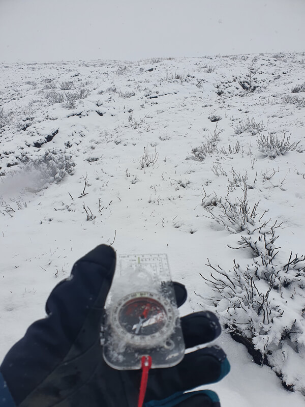
The section from Millstone Rocks/Lad’s Leap to Featherbed Moss trig point and back to Laddow Rocks is largely off-path. It is moorland area and the terrain looks very similar. I highly recommend using a compass bearing across the section. In bad weather there is a high chance you can go the wrong way and the trig is only visible with about 100 metres to go.
From Laddow Rocks, this section is along a narrow path along the edge, if you struggle with vertigo this might be an issue for you (it was my friend).
There are sections of this walk that can be slightly flooded and boggy, depending on the weather conditions. I’d recommend waterproof footwear, also gaiters would be good for some sections.
Due to the remoteness I would also recommend you take extra warm layers and waterproofs to be ready for all weathers once up high.
The route has almost no signposts, I recommend you take a map and compass (see below).
Please keep the Peak District beautiful and respect everyone who uses the park. Take ALL your rubbish home to dispose of and remember close gates (as you found them). Thank you so much.
Would you know what to do in an emergency situation?

We have a guide with what to do, who you need to call and also some useful kit that should be in your backpack. Ask us any questions in the comments or via our social media.
Happy hiking + stay safe
read herePeak District weather
Check the weather for your walk location and hills. The moorlands are very remote and there is no protection from incoming weather.
The weather can vary widely from your start location to the top of the hills so please check the conditions and make sure you have warm clothes/waterproofs if necessary.
- BBC Weather for Crowden
- Met Office weather for the Peak District
- Met Office weather for Black Hill and/or MWIS (Mountain Weather Information Service) for the Peak District.
Ordnance Survey walk map
The map for this walk is the Ordnance Survey OL1 – Peak District (Dark Peak Area). Check prices here with Ordnance Survey or Amazon. If you’re hiking in all weathers the Active OS maps are good to have.
And don’t forget your compass, I recommend the Silva Expedition or the Silva Classic compass.
For online maps, I recommend the OS Online App (I have been using it for many years and it is worth getting if you want to start walking more). Check prices here for the one-month or annual option with the OS Online App. All the walks on the website are created using OS Online + you can download them to the App.
Trig walk route
Stage 1 – Crowden to Featherbed Moss Trig
Distance: 2.8 miles/4.5 km
Grid reference SK 07250 99285
From the car park take the footpath towards the campsite. Go through the hole in the wall and turn right (this is also where the toilets are). Walk up the path then turn left past the campsite down the road. Go though two gates and continue walking as the path begins to incline. Shortly after the second gate, look for the Pennine Way fingerpost sign, turn right here.

Walk up the track through three wide gates (you may need to climb the stiles if they are locked). You’ll then reach a small gate at the stone wall, go though and turn left on a narrow track as it leads uphill. Follow this towards a stone wall, here the path bends round to the right and follows the wall uphill.

Go over a wooden stile (dog-friendly) and continue on the path heading uphill on the narrow track, (crossing over the broken stone wall about halfway up – it’s easy to miss this in bad weather). Eventually the path it flattens out, but this is where it starts to get boggy! Navigate around the boggy areas as best as you can!
There’s a large cairn shortly before you reach Lad’s Leap (where Hollins Clough runs down). This is where you leave the main path to head across the moorlands to Featherbed Moss trig (as mentioned above it’s best to take a compass bearing here).

Cross over the stream, so you’re on the left-side of it. There is a faint path that follows Hollins Clough but about halfway this disappears (or it did the day I hiked because of heavy snow!)
After 1.4 km following the Clough (330 degrees), the trig should be about 200 m in a northeasterly direction (60 degrees).

Stage 2 – Featherbed Moss Trig to Black Hill
Distance: 3.5 mile/5.7 km
Grid reference SE 04640 01142
From the trig, it’s best to take another compass bearing (60 degrees) across the moorland back to the path for about 900 m to a fence with a stile (always boggy). Then follow this path down to meet the Pennine Way path near Laddow Rocks.

Once you join the path on the edge of the moorland, turn left and follow the narrow rocky path all the way along the edge. After about 1 km the path starts to decline and eventually meets Crowden Great Brook. You’ll cross over the brook a couple of times, as the path goes over and back again.

Then it’s through a gate, from here the path is mostly flagstoned all the way to Black Hill (Holme Moss trig). It’s a gradual incline as you hike up to Black Hill summit and the trig point.
Stage 3 – Black Hill to Hey Edge trig
Distance: 2.9 miles/4.7 km
Grid reference SE 07820 04671

Now it’s time to head off from the flagstoned Pennine Way path and back across the moorlands. The first section is very boggy but it does get better. Continue following the path across the moors, you’ll go past two small tarns one near the beginning and one further along.
The path is a mix of moorland then some more established rocky sections through a lumpy area of terrain (you’ll see what I mean as you walk through). Then you’ll go over a stile and on to more open land, still heading in a southerly direction.

About 1 km down the path from the second small tarn on Westend Moss, you can see the path split towards Hey Edge trig. Take the left-hand fork as the path now gradually heads up to the trig point.

Stage 4 – Hey Edge trig to Crowden
Distance: 1.6 miles/2.6 km
Grid reference SE 08040 00471
From the trig point at Hey Edge, you can see two paths leading away from it, take the right-hand path heading down, this will take you via the old quarry.

Follow the path down and at the quarry head down to pick up the wide track as it leads out the quarry at the far end. Continue on this track as it bears round to the left and downhill to a gate/stile. Go through, head down for a short distance, then look for a path leading off the track on the right.
Walk along here, go over another gate/stile and follow it around in front of the quarry. There’s then a (short-cut) path leading to a stile in the corner of the fence you’re walking to next.

Walk down this path, go over another stile, then continue down to a gate/stile at the bottom. Go over and turn left down the track to the campsite. Take the path down the side of the campsite and back to the car park.
Ask me any questions about this route from Crowden in the comments below.
Other options for this walk
Shorten the walk
Want to miss out the Featherbed Moss Trig (and the difficult moorland section)? We have another shorter route that ascends via the Pennine Way path and loops round to Black Hill, this has the option to include or miss out Hey Edge Trig.
Read the full route here to see if this sounds a better option
More walks in the Peak District
Love the hikes in the Dark Peaks? You might like these Peak District circular walks.
- Blackden Brook to Kinder Plateau (Scramble + Waterfall Route)
- Kinder Scout Walk From Hayfield (Via Red Brook Scramble) | 9-Mile Route
- Dovestone Reservoir Walk (+ Trinnacles) – Saddleworth | 12-Mile Route
- Harry Hut + Lantern Pike Trig Walk From Hayfield | 10-Mile Route
Or check out all our Peak District walking routes here
Peak District Walks is a FREE online resource. Are you enjoying the walks? You can say thank you and buy me a coffee here. Thank you very much 🙂
Peak District charity patches
Read about the charity here.


Charity Patches

Charity Patches

Charity Patches

Charity Patches

Charity Patches

Charity Patches
Need more help planning your Peak District trip?
Join our Peak District walks Facebook page, follow us on Instagram and Twitter for inspiration.
More information on the Peak District, including transport options, where to stay, best Peak District pubs + other useful resources.
Check out the 7 YHAs in the Peak District and find the best walks direct from your accommodation.
Find out what maps you will need for your trip here.
Top tips - Read our useful guides on hiking tips here.
Guided Walks with an introduction to map reading (see dates here).
Visit our hiking recommendations page, (footwear, clothes + kit).
Or get in touch and I will help as best I can :).
Please note 'Peak District Walks' accepts no liability for any injuries or accidents resulting from walking our routes. We always recommend you wear appropriate footwear to avoid injuries and to take a paper map and compass on your walks. Read more here.
*Peak District Walks participates in the Amazon Services Associates Programme, as well as other affiliate programmes. If you purchase through these, Peak District Walks earn from the qualifying links. This is at no extra cost to you. Read more here.
The GPX file is of a 7 k linear walk
Oh no, sorry about that, I’ll check out and get it fixed. Thanks for letting me know 🙂
Hi Pat, I’ve just been in to the file but it’s the right one? It’s a 17 km route so not sure if you maybe mis-read or if you’re having a glitch with extracting file? Let me know if you’re still struggling and I’ll send direct for you 🙂