This short walk to Magpie Mine from Ashford-in-the-Water is a lovely route, including rivers, woods and fields all in one walk, oh and a little uphill walking!
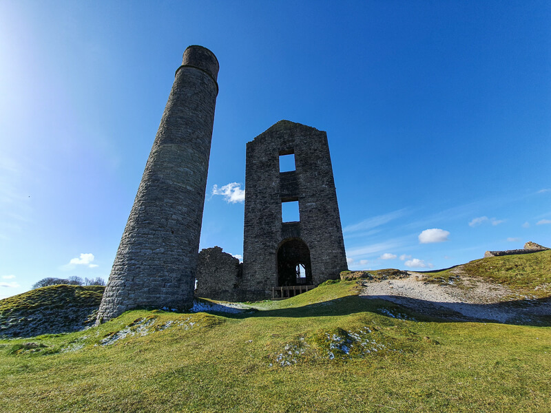
Magpie Mine is a disused lead mine, and covers a large area with many buildings still in tact. It makes a great places for both adults and children to explore. And for photograph lovers, the dark skies make for some impressive starry night photos of Magpie Mine.
From Ashford-in-the-Water, you cross the River Wye and walk alongside it before turning off into Little Shacklow Woods and an uphill walk up to the village of Sheldon. The walk then goes via farm land to reach Magpie Mine at the highest point on the walk.
Once you’ve explored the old mine, it’s back to Sheldon and a gradual descent via Great Shacklow Woods to the River Wye, where you follow it back to the start at Ashford-in-the-Water.
Here you will find details on how to get to the start of the walk at Ashford-in-the-Water, parking, route information, map, GPX file, plus a detailed step by step guide of the walk.
Let me know in the comments if you’ve done this short Magpie Mine walk and what you think!
Buy a printable/downloadable PDF route guide for the walk here.
Fancy a longer route? Why not check out our 8-mile walk to Magpie Mine
Magpie Mine short walk from Ashfield-in-the-Water

Walk information + GPX
Walk type: Short circular walk
Distance: 5.5 miles/8.9 km
Walk time: 2-3 hours
Total ascent: 334 m/1,096 ft
Highest point: 330 m/1,082 ft
Walk highlights: Ashford-in-the-Water, River Wye, Little Shacklow Woods, Magpie Mine
Trigs: 0
Ethels: 0
Stiles: 6-7
Magpie Mine short walk map

© Crown copyright and database rights (2024) OS 002572460
Click for online mapWalk start point
Start grid reference: SK 19414 69799
Car parking address: Ashford-in-the-Water car park, 4 Court Lane, Ashford in the Water, Bakewell, DE45 1QG – Google maps

This is a small car park in the village of Ashford-in-the-Water. These are community toilets and stay open with donations, suggested donation is £2 for parking. Please remember to take change with you to pay in the donation box.
Please note during busy periods and weekends the car park can fill up quickly, so it’s best to arrive early to get a space or visit mid-week. There’s a small amount of street parking but please be aware of the local residents when finding a space.
Alternative car park (different location)
If you find it’s too busy here, there’s another cars parks you could use for this walk. White Lodge car park is 1 km from the route, you’d just need to walk along the river to join with it on the stage 4 section. Costs £1.50 to £4.75.

Public transport
There is a TransPeak bus that goes between Buxton and Bakewell and stops in Ashford-in-the-Water to start your walk.
Facilities on the walk
There are public toilets available at the start of the walk at Ashford-in-the-Water, these remain open from walker donations, so please remember to take some change with you.
There are also toilets at White Lodge car park, 1 km from the route (near the end of the walk).

The village of Ashford-in-the-Water has plenty of facilities before or after your walk. There are a couple of pubs, The Bulls Head and Ashford Arms, as well a small shop and Aisseford Tearooms, all situated on Church Street, round the corner from the car park.
There’s also a small pub in the village of Sheldon, which you walk past on the walk – Cock and Pullet, Sheldon.
Water on your walk – I recommend a filter water bottle for your Peak District walks, it saves you from carrying extra weight and you can fill up safely and drink water from the streams on your walk.
Other useful information
There are some sections of this route that go via roads, these are mostly quiet roads, however, please take care on these parts.
From the village of Ashford-in-the-Water up to Magpie Mine the temperature can drop, plus it’s quite exposed so on a windy day it can be colder than when you set off. Please take warm clothes with you.
The woodland part of the walk can be muddy in places, also the cave mentioned in the route did look unstable in places so please take care. It’s certainly nice to look at but I opted not to go exploring (you’ll see what I mean if you go there).
Both Little Shacklow Woods and Great Shacklow Woods were full of wild garlic, great for foraging during early Spring months.
The route has some signposts but we always recommend taking a map and compass on your walks. See details below.
Please keep the Peak District beautiful and respect everyone who uses the park. Take ALL your rubbish home to dispose of and remember close gates (as you found them). Thank you so much.
Would you know what to do in an emergency situation?

We have a guide with what to do, who you need to call and also some useful kit that should be in your backpack. Ask us any questions in the comments or via our social media.
Happy hiking + stay safe
read herePeak District weather
Check the weather for your walk location.
The temperature can vary from the village to Magpie Mine, so even if it feels warm, it’s worth taking a jacket to put on at Magpie Mine.
- BBC Weather for Ashford-in-the-Water
- Met Office weather and/or MWIS (Mountain weather information service) for the Peak District
- Met Office weather for Bakewell
Ordnance Survey walk map
The map required for this walk is the Ordnance Survey OL24 – Peak District (White Peak Area). Check prices here with Ordnance Survey or Amazon. If you’re hiking in all weather the Active OS maps are good to have as they are laminated so better on rainy days.
View both Peak District map options here.
And don’t forget your compass, I recommend the Silva Expedition or the Silva Classic compass.
For online maps, I recommend OS Online App (I have been using it for many years and it is worth getting if you want to start walking more). Check prices here for the one-month or annual option with OS Online App. All the walks on the website are created using OS Online + you can download them to the App.
See both maps that cover the Peak District here.
Want to learn more map skills? Check out our Guided Walks with map reading skills here.
Magpie Mine short walk route
Stage 1 – Ashford-in-the-Water to Little Shacklow Woods
Distance: 1 miles/1.6 km
Grid reference SK 19445 69776
Leave the car park, walk past the houses and turn left down the road towards the village. Cross the road at the corner and walk over the bridge across the River Wye.
Cross the road and turn right walking down the pavement for about 200 m. Then at the next road on the left, turn down here and continue until you reach a track at the point where the road bends to the left.

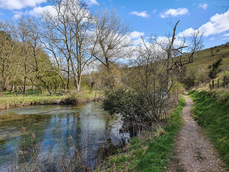
Go through the gate, then ahead is a second gate leading you to a footpath alongside the River Wye. Walk along the path for about 500m, you go through another gate then in-between a wide gap in the stone wall. Here is where you turn left and leave the River Wye.
The footpath heads towards the trees, continue walking then go through the gate into the Little Shacklow Woods.

Stage 2 – Little Shacklow Woods to Magpie Mine
Distance: 1.5 mile/2.4 km
Grid reference SK 18338 69538
The path starts to slightly head upwards into the woods, some parts of this path can be muddy. Follow the path as it continues heading up. After about 500 m, follow the path as bends around to the left (there’s another faint path continuing straight ahead, but ignore this).

At this point, where the path bears left, there’s a cave up on the left. The rocks did look unstable when I visited so I opted not to go inside, but it’s nice to look at! Keep following the path up through the woods, it’s a slow and steady uphill but eventually you reach a stone wall and small gate.
Go through then continue to another small gap and gate that brings you out to a large grassy area with houses on the right (Sheldon village). Head up towards the wall and go through the gate in the wall.

Turn left, heading up the road for about 200 m until you see a footpath on the right. Walk down here, you’ll walk next to some gates down a narrow path then over another stone stile. Keep heading across the grass, now Magpie Mine will be in sight, in the corner there’s a gate to walk though.
Magpie Mine is a permissive Open Access area, so you’re able to walk around the old lead mine and explore all the old buildings.
(As you go through the gate into the access area, look to your right where you’ll see the stone stile hiding in the corner – this is where you’ll continue the walk.)

Stage 3 – Magpie Mine to Sheldon
Distance: 0.6 miles/1 km
Grid reference SK 17260 68186
Once you’ve finished exploring Magpie Mine, return back towards the gate your entered, but this time bear left into the corner of the wall where there’s a stone stile (hopefully you spotted on your way in).

Heading in a northerly direction, walk towards the next wall and through the gap in the stone wall. Keep walking straight across to a small gate in the stone wall.
Slightly to your left, there’s another gate with a tall post (yellow marker on top), go though here and follow the path to the next stone wall with three stone steps over it (and another tall yellow marker signpost).

Now head directly across to the far right-hand corner, another stone stile and out in a grassy area next to some houses. There’s a very small gap and gate which leads to the main street of Sheldon. Turn right and walk down the road.
Continue walking, there’s a pub called the Cock and Pullet on the right, however your footpath is just before this on the left, signposted with a green Public Footpath sign. Go over the stone wall via the stone steps and down the footpath alongside the house.

Stage 4 – Sheldon to Ashford-in-the-Water
Distance: 2.4 miles/3.8 km
Grid reference SK 17413 68798
Go over another stone stile and another on to a track. Turn left here and walk down until you reach a footpath on your right, signposted Public Footpath with a wooden pole.

Walk down here, though a gap in the wall then down to a small gate in the corner. Walk along then over three stone steps over a wall in a field. Follow the wooden signposts across the fields until you reach a wall leading into the woods, the gate is on the left (photo below) heading into the woods.

Once in the woods follow the path down towards the River Wye. As you reach the footpath running along the lower route, turn right and then follow this alongside the river.
(This is the point where you’d join the route if you parked at White Lodge car park.)
You’ll go past some old buildings, through a gate (or stile) and then it will bring you back to the point where you left the path to enter Little Shacklow Woods.
Keep walking along the river, though the gate, then onto the side road, that links into the main road. Cross over, back across the bridge and it’s up the road, past the houses, back to the car park on the right.
Ask me questions about this route in the comments below.
Buy a printable/downloadable PDF route guide for the walk here.
Other walk options
Longer route?
Fancy visiting Magpie Mine but would like a longer route? Try our Magpie Mine 8-mile walk from Ashford-in-the-Water that goes via Deep Dale, Monsal Dale and the Monsal Trail.
More walks in the Peak District
Love the 5 mile walks in the Peak District? You might like these circular walks.
- Bradford Dale Short Walk Near Youlgreave | 5-Mile Route
- Thor’s Cave Walk + Manifold Valley From Wetton | 5-Mile Route
- Wolfscote Dale + Biggin Dale Walk From Hartington | 5-Mile Route
Or check out all our Peak District walking routes here
Peak District Walks is a FREE online resource. Are you enjoying the walks? You can say thank you and buy me a coffee here. Thank you very much 🙂
Peak District charity patches
Read about the charity here.


Charity Patches

Charity Patches

Charity Patches

Charity Patches

Charity Patches

Charity Patches
Need more help planning your Peak District trip?
Join our Peak District walks Facebook page, follow us on Instagram and Twitter for inspiration.
More information on the Peak District, including transport options, where to stay, best Peak District pubs + other useful resources.
Check out the 7 YHAs in the Peak District and find the best walks direct from your accommodation.
Find out what maps you will need for your trip here.
Top tips - Read our useful guides on hiking tips here.
Guided Walks with an introduction to map reading (see dates here).
Visit our hiking recommendations page, (footwear, clothes + kit).
Or get in touch and I will help as best I can :).
Please note 'Peak District Walks' accepts no liability for any injuries or accidents resulting from walking our routes. We always recommend you wear appropriate footwear to avoid injuries and to take a paper map and compass on your walks. Read more here.
*Peak District Walks participates in the Amazon Services Associates Programme, as well as other affiliate programmes. If you purchase through these, Peak District Walks earn from the qualifying links. This is at no extra cost to you. Read more here.
Hiya this was a beautiful walk with really easy to follow instructions until I got to this bit “Walk along then over three stone steps over a wall in a field. Follow the wooden signposts down to a gate in the far left corner leading into the woods” I never found the gate in the far left corner at all 😆 I ended up tracking back round to Sheldon then retracing my steps back to the ornate gate that led me back the way I’d come through the woods. Still loved it though so thanks 🙂
Hi Deb, I’m so glad you enjoyed the walk. I knew the exact place you meant before I even checked the route and my photos! I’ve tweaked the wording and added a new photo of the exact spot, I feel like my instructions might not have been clear and maybe sent you far left when the gate was tucked at the end of the field, I’m really sorry 🙁 I’m glad you still enjoyed the walk and maybe you can try it again another day. Happy hiking, Becky 🙂
Great walk, just be aware it’s muddy by the river and up through the woods in this wet autumn.
Yes, good shout Phil, most of the walks in the Peak District will be muddy and slippy in autumn and winter 🙂
We started this walk but were shattered by the time we got to
Magpie mine. The first hill is very steep, wonderful views of Ashford in the Water but had to stop a few times to catch our breath.