The Derbyshire Dales has many hidden secrets spots and you can find one of those on the Bradford Dale walk near Youlgreave.
This walk starts above the dale, in a small car park away from the village. The route takes you along the Limestone Way down to the River Bradford. Shortly after you’ll see one of the first highlights and unique spots on the walk, hidden in the wall as you walk past it!
From here you head across fields with plenty of sheep towards the village of Youlgreave, dropping down so you’re walking alongside the river again. A short distance outside the village next to the footpath there’s a small swim spot, perfect for cooling off on a hot summer’s day! And lastly, you head back up to pick up the Limestone Way to return to the parking spot.
A beautiful short route, perfect for an autumnal or winter’s day walk. Or maybe save for a spring day when the Derbyshire Dales becomes green with new life!
Here you will find details on how to get to the start of the walk near Youlgreave, car parking options, route information, map, GPX file, plus a detailed step by step guide of the walk.
Are you planning to do this walk near Youlgreave, let me know?
Buy a printable/downloadable PDF route guide for the walk here.
Bradford Dale Short Walk near Youlgreave

Walk information + GPX
Walk type: Short circular walk
Distance: 4.6 miles/7.4 km
Walk time: 2-3 hours
Total ascent: 320 m/1049 ft
Highest point: 303 m/994 ft
Walk highlights: Bradford Dale, books in the wall, River Bradford and small swimming spot near Youlgreave
Trigs: 0
Ethels: 0
Stiles: 3
Bradford Dale walk map

© Crown copyright and database rights (2024) OS 002572460
Click for online map
Walk start point

Start grid reference: SK 19401 64453
Car parking address: Moor Lane Car Park, near Youlgreave, Derbyshire. Google Location.
A small, pay and display, car park, with room for about 15+ cars, if the car park is full there are laybys further down the road where you can park but mostly this car park isn’t that busy. You can pay for parking using cards or the RingGo App. Charges are; £1.50 for up to 1 hour, £2.50 up to 2 hours, £4.00 up to 4 hours or £4.75 all day. You can find more details on car parking charges here.
Public transport
Unfortunately, there aren’t any public transport options for this walk.
Facilities on the walk
There are no public toilets available at the start of the walk at Moor Lane Car Park. The nearest ones are the public toilets in Youlgreave (about halfway through the walk), a short distance off the route (SK 20969 64153).
On the route there are no shops, however, if you want to treat yourself after the walk you could drive into Youlgreave where there are a few shops and a pub (The Bull’s Head Youlgreave) where you can end your walk in style!
Water on your walk – I recommend a filter water bottle for your Peak District walks, it saves you carrying extra weight and you can fill up safely and drink water from the streams on your walk.
Other useful information
The beginning of the route follows sections of the Limestone Way, which is signposted, but I’d also recommend taking a map/compass for the walk – see below which map you need for the walk.
Please note – In summer months the swimming spot in Youlgreave can be very busy on hot sunny days. Since it’s only small be prepared to change your plans if necessary.
Check the weather for your walk location and hills before you set off
- BBC Weather for Youlgreave, Derbyshire
- Met Office weather and/or MWIS (Mountain weather information service) for the Peak District
- Met Office weather for Youlgreave, Derbyshire and/or MWIS (Mountain Weather Information Service) for the Peak District
Ordnance Survey walk map
The map required for this walk is the Ordnance Survey OL24 – Peak District (White Peak Area). Check prices here with Ordnance Survey or Amazon. If you’re hiking in all weather the Active OS maps are good to have as they are laminated so better on rainy days.
View both Peak District map options here.
And don’t forget your compass, I recommend the Silva Expedition or the Silva Classic compass.
For online maps, I recommend OS Online App (I have been using it for many years and it is worth getting if you want to start walking more). Check prices here for the one-month or annual option with OS Online App. All the walks on the website are created using OS Online + you can download them to the App.
See both maps that cover the Peak District here.
Want to learn more map skills? Check out our Guided Walks with map reading skills here.
Want to read later? Save the walk to Pinterest

Bradford Dale walk route
Stage 1 – Moor Lane Car Park to Bradford Dale
Distance: 1.1 miles/1.7 km
Grid reference SK 19401 64453
From the Moor Lane Car Park, start walking along the Limestone Way path. There’s a gap in the top left corner that leads you on to it down a track. Walk until you reach a small gate (photo below). Now head diagonally across the field to pick up a narrow track, (be careful as the ground is uneven in places).

Walk down the path, ignore the first stile signposted Limestone Way (this stops you from walking on the road). Continue walking parallel to the road, past a small pond. At the next stile, climb over and go across the road straight over to the next stone stile signposted Limestone Way.
Head downhill for 100 m across the grass to another gate. Then turn right and walk up the road (on a pavement) until you reach a fingerpost on the left, signposted Limestone Way (photo below). Head down through the woods and follow the path as it zig-zags down. Go across the bridge over River Bradford to reach Bradford Dale.

Stage 2 – Bradford Dale to Youlgreave
Distance: 1.3 mile/2.1 km
Grid reference SK 19968 63620
Turn right after you’ve crossed the bridge along the footpath. On your left look for the books in the wall, next to the old sheep wash (hidden in the summer when it’s overgrown). Shortly after turn left down a narrow footpath leading off the main track. Walk until you reach a bridge, cross over and keep on the narrow path.

Continue up the metal steps and the path brings you to an open field. There’s no obvious path, but keep next to the tree line until you reach a stone gap in the wall. You’ll now walk through several fields, with small gates in between each boundary (6 in total) – in most cases you can see the next gap once you walk through each one.
At the seventh gate (next to a phone pole), you’ll see three arrow choices. Keep going straight and then through another narrow stone gap and gate, you now come out on the path with views down to the river and towards Youlgreave village.

Stage 3 – Youlgreave to the stone bridge
Distance: 0.9 miles/1.5 km
Grid reference SK 21355 64007
Head downhill to the gate, go across the stone bridge, turn left and go through the gate and head alongside the River Bradford towards Bradford Dale. As you walk along the footpath you’ll see the small wild swimming spot with a sign on the left.

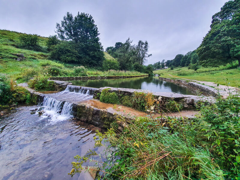
Walk along the river, through next stone gap/gate and across the stone bridge to the other side. Continue walking down next to the River Bradford towards Bradford Dale. You’ll see several sluice gates on this section, previously used to control the water levels for the trout fishing (no longer there).
Stage 4 – Bridge to Moor Lane Car Park
Distance: 1.3 miles/2.1 km
Grid reference SK 19985 63647

At the bridge (the one you crossed at the beginning), go back across and head up the track. There’s a narrow track a short way up, turn right here and stay walking alongside the river, through a gate and follow it as it then ascends back up to the road.
At the road, turn left (there’s a pavement) and follow the path. The road splits, keep left until you reach the gate on the corner of the road (where you walked through at the beginning).
Go through the gate, up the field, to the stone stile, across the road and over the stone stile on the other side. Turn left, past the pond and follow the narrow track up next to the boundary. As you reach the open field, cut diagonally across (retracing your steps), go through the gate, along the track and you’re back at the car park!
Any questions about the walk, ask me in the comments below?
Buy a printable/downloadable PDF route guide for the walk here.
Other options for this walk
Extend the walk

Add another mile on to the walk if you’re having a lovely day and want to extend by adding a short loop on. At this stone bridge in Youlgreave, you turn right instead of left to add another mile on to the walk.
Read the full route, map + GPX file here – 6-mile Bradford Dale walk
More walks in the Peak District
Love the walks in the Derbyshire Dales? You might like these Peak District circular walks.
Or check out all our Peak District walking routes here
Save me to your Hiking boards on Pinterest


*Peak District Walks participates in the Amazon Services Associates Programme, as well as other affiliate programmes. If you purchase through these, Peak District Walks earn from the qualifying links. This is at no extra cost to you. Read more here.
Peak District Walks is a FREE online resource. Are you enjoying the walks? You can say thank you and buy me a coffee here. Thank you very much 🙂
Peak District charity patches
Read about the charity here.


Charity Patches

Charity Patches

Charity Patches

Charity Patches

Charity Patches

Charity Patches
Need more help planning your Peak District trip?
Join our Peak District walks Facebook page, follow us on Instagram and Twitter for inspiration.
More information on the Peak District, including transport options, where to stay, best Peak District pubs + other useful resources.
Check out the 7 YHAs in the Peak District and find the best walks direct from your accommodation.
Find out what maps you will need for your trip here.
Top tips - Read our useful guides on hiking tips here.
Guided Walks with an introduction to map reading (see dates here).
Visit our hiking recommendations page, (footwear, clothes + kit).
Or get in touch and I will help as best I can :).
Please note 'Peak District Walks' accepts no liability for any injuries or accidents resulting from walking our routes. We always recommend you wear appropriate footwear to avoid injuries and to take a paper map and compass on your walks. Read more here.
Pingback: Magpie Mine Short Walk From Ashford-in-the-Water | 5.5 Mile Route - Peak District Walks
Pingback: Parkhouse Hill + Chrome Hill Walk From Earl Sterndale | 5-Mile Route - Peak District Walks
Pingback: Lathkill Dale Walk (+ Waterfall) From Monyash | 4-Mile Route - Peak District Walks
Pingback: Robin Hood's Stride Walk + Bradford Dale From Elton | 8-Mile Route - Peak District Walks