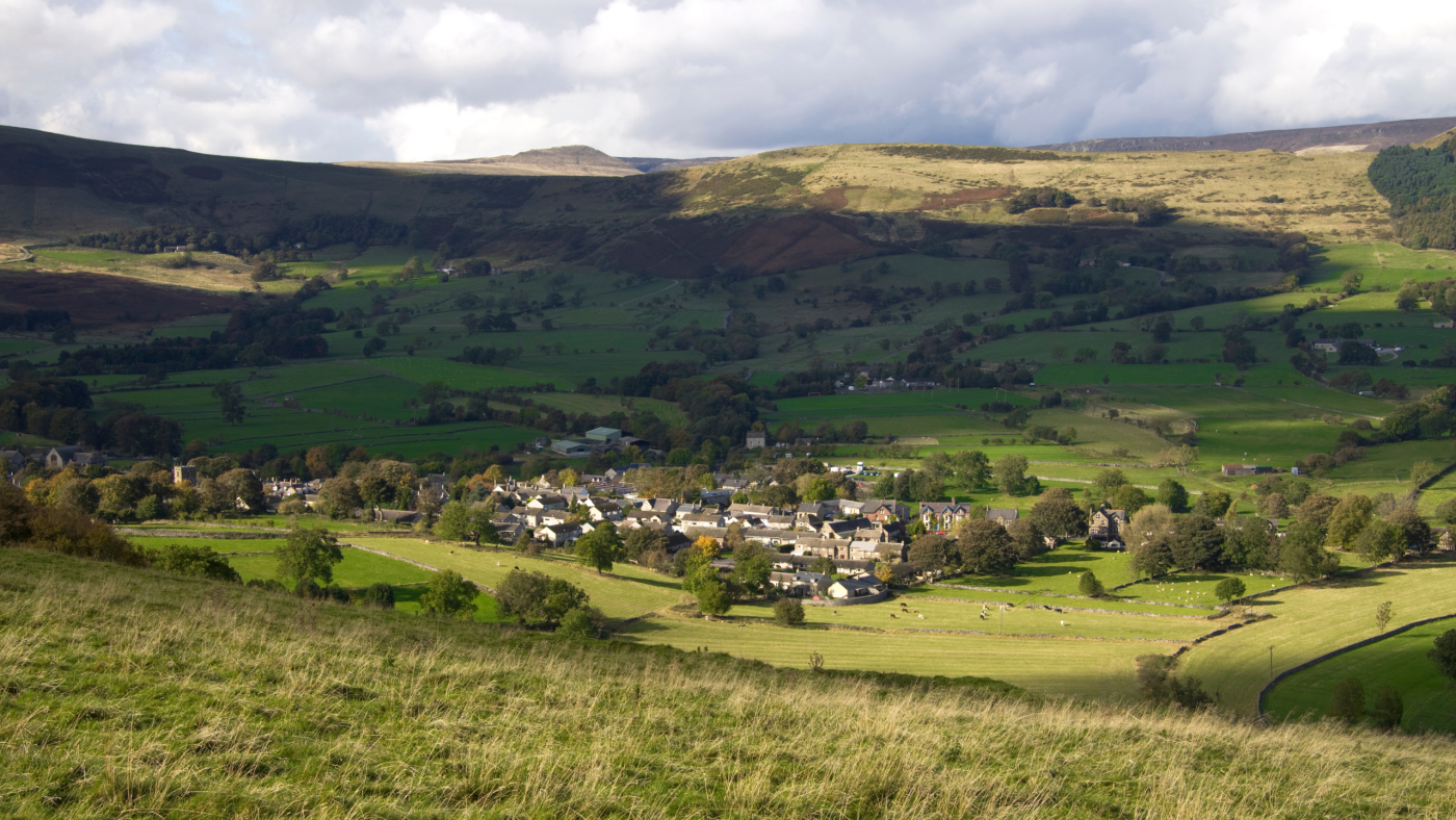
Castleton is one of the Peak Districts most popular villages. A fantastic weekend base for walkers who want to head out into the hills during the day and enjoy the village in the evening.
If you’re lucky enough to have a whole weekend in Castleton you’ll want to make the most of it and we’re here to help. Below we’ve chosen some of our favourite things to do in and around the village, as well as hand-picking some of our best walks from Castleton.
Let me know in the comments what your favourite thing about Castleton is!
How to Spend the Perfect Walking Weekend in Castleton
Castleton sits at the head of the Hope Valley. First settled by the Celts, it was able to grow and prosper through lead mining. One of the oldest lead mines in England can be found nearby and is thought to have been used by the Romans, Saxons and Danes. When mentioned in the Domesday book in 1086 Peverel’s Castle was referenced. You can still visit the remains of this castle today as it watches over the village from above.
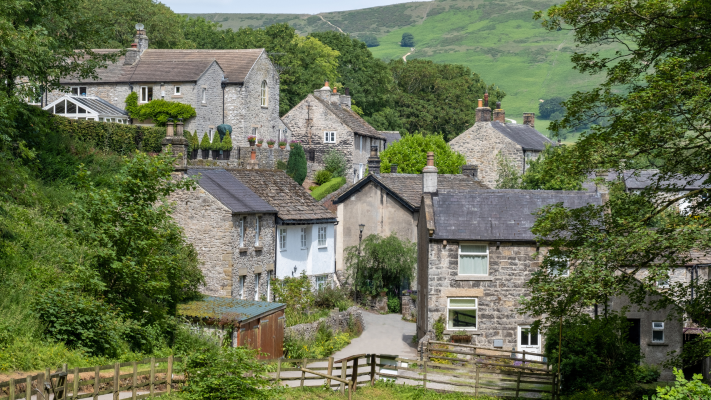
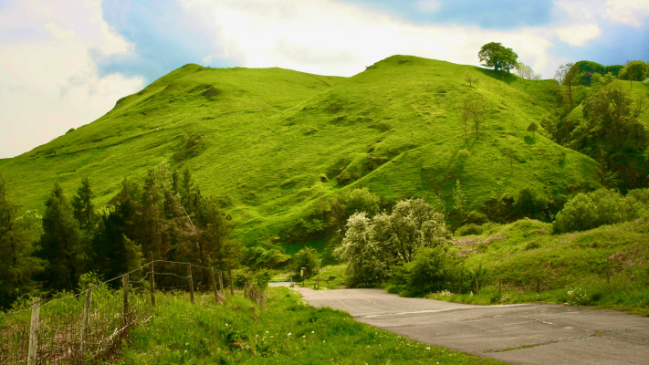
Nowadays Castleton is a thriving village, although still with a fairly small population of around 540 residents. It has a wide variety of options for places to stay, eat, drink and shop as well as being a walkers paradise. Surrounded on three sides by hills, including the infamous Mam Tor, there are countless options for hikes both short and long.
Full walk descriptions, maps and GPX of each walking route can be found in their main walk post.
See the sunrise from Winnats Pass
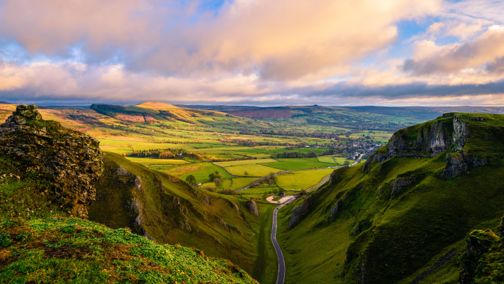
Winnats Pass is a dramatic limestone gorge in the Peak District. Driving along the road which passes through it feels as if you’re entering a movie set. Equally as dramatic are the views from the top if you decide to hike up it. It’s not an easy walk but the vista which opens up before you makes it well worth it.
Our five-mile Winnats Pass Walk from Castleton also includes Mam Tor. If you’re feeling fit and able it’s a great option to do early morning, in order to catch the sunrise from the top of the pass. Read the full walk description, with map and GPX, and decide whether it’s the right walk fro you.
Winnats Pass Walk from CastletonWatch the paragliders and hang gliders on Mam Tor
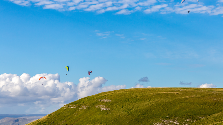
Paragliding and hang gliding are very popular in certain parts of the Peak District. There are some ideal spots for take-off and landing and its’ undeniably a beautiful place to soar above. If you’re an adrenaline junkie and fancy a whole different view of the Peak District there are opportunities for you to fly yourself, with tandem flights for those new to air-sports. You can find out more about places you can book flights and learn to fly here.
Another option is to simply enjoy watching the colourful canopies soaring above your head from the reat vantage point of Mam Tor. In the right conditions there are often tens of people taking off and landing from its slopes and it adds a fantastic element to your hike. From Castleton you can do our 7-mile Mam Tor and Lose Hill Walking Route, which takes you along part of the Great Ridge and gives you multiple vantage points to watch the paragliders soar!
Mam Tor and Lose Hill WalkVisit the gift shops and purchase some Blue John stone
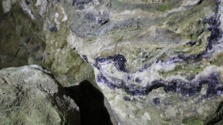
Once you’ve been out hiking and maybe refreshed at one of the pubs or cafes, a stroll around the shops is a great way to finish your day. Blue John Stone is a semi-precious stone which can only be found in the hillsides surrounding Castleton, as such it is Britain’s rarest mineral. It was discovered by miners mining for lead in the area but the Romans were thought to have found it many years before, even taking some of it back to Pompeii with them.
You can see the stone in its un-mined state by visiting some of the caves around Castleton (more on that later). If you’d like to see a more polished version and even take some home with you the shops in the village are the perfect place.
There are a wide range of gift and outdoor shops, many of which stock Blue John Stone in various forms.
Learn about the history of Castleton and the Peak District in the National Park Centre

You can finish your browse around the shops by dropping in to the National Park Centre. The centre is located beside Castleton’s largest car park and is filled with exhibits teaching you about the history, geography and etymology of the area.
The National Park Centre is run by the Peak District National Park Authority and has recently undergone a refurbishment. It’s well worth taking a look around to understand the amazing landscape surrounding you.
National Park CentreWalk the broken road
First constructed in 1819 the A625 was designed to make an alternative, easier passage out of Castleton than the steeper Winnats Pass. Sadly it regularly fell victim to Mam Tor living up to its alternative name of the Shivering Mountain, so called due to the frequent landslips on its sides.
The road was repaired many times but after a final landslip damaging it in the late 1970’s the decision was made to close that part of the road permanently. You can still hike part of the undulating and broken road by parking near Odin Mine and following the instructions from our friends at the Peak District National Park Authority here. A great way to spend a spare hour or so when you’re visiting Castleton!
Hike the Broken RoadHike up a glacial valley
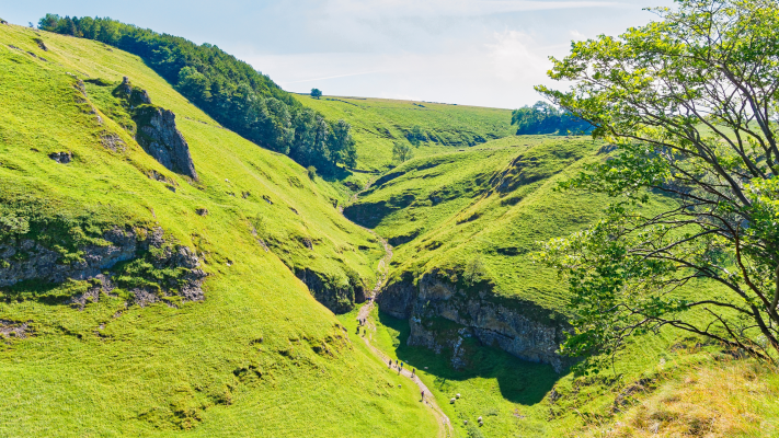
Cave Dale is another of those places which feels like an instant movie scene moment. Formed by glacial water carving its deep valley through the local limestone it’s astounding to think that the dale we now hike through was once underwater! When I hike it I like to think of giant historic creatures swimming through its depths!
You enter Cave Dale from a little footpath between houses at the back of Castleton. As little as 200 years ago you would have ben entering through a limestone arch, which has now long collapsed.
As you hike up its steep and rocky path you will spot the caves off to each side, for which the dale is named. Looking up you’ll also spot the imposing remains of Peveril Castle (check out more on that below). You’ll see from the steep sides of the dale that the castle would have been a tough one to invade!
We have a couple of walks on our site which take in Cave Dale but if you’re looking for a quick hike to fit in amongst other weekend activities check out our 2-mile Cave Dale Short Route from Castleton.
Short Cave Dale HikeStorm the castle!
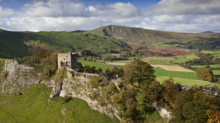
Having seen Peveril Castle from below in Cave Dale you can also get up close and personal with it by visiting it atop its hill!
Peveril Castle pre-existed the village of Castleton, having been first constructed in the 11th century. Castleton village began growing around it around 100 years later, ordered by Royal initiative. Income from the village was essential for the castle’s estate, which took rent from town houses and fees for grinding corn in its watermills.
The castle was named after William Peveril, also known as the Keeper of the Royal Forest. It was believed that rather than a castle built for defence and warfare it was mainly concerned with protecting and governing said Royal Forest.
Peveril Castle is now cared for by English Heritage and you can learn more about its history and wander its remains. Visit their website to find out more.
Visit Peveril CastleHead underground!
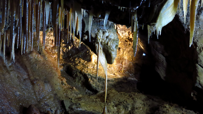
We all know hiking in the hills is a brilliant way to see an area. But, while you’re in Castleton you can head underground to see a whole new layer!
There are a variety of caves surrounding the village which you can pay to enter and tour. Each with their own unique selling point:
- Peak Cavern is also known as the Devil’s Arse (!) and boasts the largest natural cave entrance in the UK.
- Treak Cliff Cavern has been a working mine for 300 years. Today you can visit this dog-friendly tourist attraction and learn all about the cavern and its history.
- Visit Speedwell Cavern and you can take a trip by boat through its 250–year-old lead mine tunnel and on into its cathedral-like cavern to visit the Bottomless Pit!
- The Blue John Cavern is home to 8 of the 15 known veins of Blue John Stone and its series of caverns are considered to be the finest range in Great Britain.
Enjoy some food and drink

All that adventuring is sure to make you build up a thirst and appetite! Luckily you’re spoilt for choice in Castleton, with its wide range of pubs, cafes and coffee shops. There’s also a fantastic chip shop tucked away off the market place!
If you haven’t worked up enough of an appetite from our suggestions above you can check out all our walking routes from Castleton here.
Castleton Walks
Do you have any more questions about Castleton? Ask me in the comments below.
Ordnance Survey Walk Maps
For these walks, there are two maps that cover them OL1 – Peak District (Dark Peak Area) and OL24 – Peak District (White Peak Area)
Shop online at Ordnance Survey
And don’t forget your compass, I recommend the Silva Expedition or the Silva Classic compass.
For online maps, I recommend the OS Online App (I have been using it for many years and it is worth getting if you want to start walking more). Check prices here for the one-month or annual option with the OS Online App. All the walks on the website are created using OS Online + you can download them to the App.
Check prices here for the one month or yearly option with OS Online App.
More walks in the Peak District
Want some more walking ideas in the Hope Valley? You might like these Peak District walks.
- Walks from Edale
- Hope to Edale Walk – 9-mile route
- River Derwent Walk from Hathersage – 5-mile route
- Padley Gorge, Higger Tor + Stanage Edge Walk From Hathersage | 12-Mile Route
Or check out all our Peak District walking routes here
*Peak District Walks participates in the Amazon Services Associates Programme, as well as other affiliate programmes. If you purchase through these, Peak District Walks earn from the qualifying links. This is at no extra cost to you. Read more here.
Peak District Walks is a FREE online resource. Are you enjoying the walks? You can say thank you and buy me a coffee here. Thank you very much 🙂
Peak District charity patches
Read about the charity here.


Charity Patches

Charity Patches

Charity Patches

Charity Patches

Charity Patches

Charity Patches
Need more help planning your Peak District trip?
Join our Peak District walks Facebook page, follow us on Instagram and Twitter for inspiration.
More information on the Peak District, including transport options, where to stay, best Peak District pubs + other useful resources.
Check out the 7 YHAs in the Peak District and find the best walks direct from your accommodation.
Find out what maps you will need for your trip here.
Top tips - Read our useful guides on hiking tips here.
Guided Walks with an introduction to map reading (see dates here).
Visit our hiking recommendations page, (footwear, clothes + kit).
Or get in touch and I will help as best I can :).
Please note 'Peak District Walks' accepts no liability for any injuries or accidents resulting from walking our routes. We always recommend you wear appropriate footwear to avoid injuries and to take a paper map and compass on your walks. Read more here.