
Here’s a great route for all you hiking lovers! This linear route begins from Hope and ends in Edale taking in the delights of Win Hill and Crookstone Hill via the Kinder Plateau on the way.
We don’t have many linear walks available mainly because of the logistics of getting from the finish back to the start! But this walk is perfect for everyone to enjoy, whether you travel by car or public transport because it starts and finishes at a train station!
From Hope train station, you begin with an uphill climb to the summit of Win Hill, with stunning views of the Hope Valley and Ladybower Reservoir. Then you continue your walk, heading down along a wide track and past Hope Cross. On this section of the walk you can see your route ahead and the village of Edale nestled between the hills.
Then it’s up the eastern side of the Kinder Plateau where you walk along the edge now heading west. There’s an option to detour off-path to tick off Edale Moor trig point, approximately 500 m across the boggy moorland.
You’ll head down via Ringing Roger path which brings you out into Edale village, it’s a short walk through the village to the train station at the opposite end near The Ramblers Inn.
Here you will find details on how to get to the start of the walk at Hope and finish at Edale, route information, map, GPX file, useful tips, plus a detailed step by step guide of the walk.
Photos of this walk – I’ve hiked this walk in all weathers including most recently in the snow. I’ve included some snowy pictures because they are pretty but I’ve also added some older useful ones that you can see the route due to the heavy snow making it difficult to see the path!
Have you done many train station walks? Let me know if you’d like to see more in the comments.
Win Hill + Kinder Plateau from Hope to Edale

Walk information + GPX
Walk type: Medium challenging linear walk
Distance: 8.8 miles/14.1 km
Walk time: 5-6 hours
Total ascent: 619 m/2,030 ft
Highest point: 556 m/1,824 ft
Walk highlights: Views of Ladybower Reservoir, Win Hill, Hope Cross, Kinder Plateau + Edale village
Trigs: 1 – Win Hill (Option to add Edale Moor trig on Kinder Plateau – off path)
Ethels: 1 – Win Hill
Stiles: 7
Win Hill + Kinder Plateau walk map

© Crown copyright and database rights (2024) OS 002572460
Walk start + finish point
This walk is designed for you to either drive or catch the train to the start point at Hope station, then from the finish at Edale to catch the train back to Hope. This is a 7 minute journey and the trains are approximately once an hour (check times here via Trainline) £4.20 for a single day ticket*
Start grid reference: SK 1805 8326
Car parking address: Hope Train Station, Station Road, Hope Valley, S33 6RU
There is a small free car park at Hope train station, or alternatively, you can park on the road leading up to the train station.
Finish grid reference: SK 1233 8536
Car parking address: Edale Train Station, Edale, Hope Valley, S33 7ZN
There is a medium sized (pay and display) car park opposite Edale train station, plus a small one at the station if you prefer to have a car at each end of the walk.
*Prices correct at time of writing.

Facilities on the walk
There are no public toilets available at the start of the walk at Hope Station. There are some as you approach the train station (if driving) so worth popping in before you start the walk – Google location
However, for the remainder of the walk, there are no toilets on the route until you reach the end in Edale where there are public toilets in the car park. If you can’t make it that far once you reach the Kinder Plateau this is a quieter section and you’ll be able to find a more discreet spot!
Other useful information
The start of the walk is mostly uphill so I’d recommend de-layering before you start your walk so you don’t get too hot and sweaty on the hike to the top.
The add-on to Edale Moor trig point is a short distance but there’s no path and it’s across moorland which can be boggy, I’ll let you decide if you want to detour! But good navigation skills are required as the plateau looks very similar in all directions so you can easily get disorientated going over the cloughs to get there.
We also have two patches available for this walk – Win Hill and Kinder Scout patches.
Please keep the Peak District beautiful and respect everyone who uses the park. Take ALL your rubbish home to dispose of and remember close gates (as you found them). Thank you so much.
Would you know what to do in an emergency situation?

We have a guide with what to do, who you need to call and also some useful kit that should be in your backpack. Ask us any questions in the comments or via our social media.
Happy hiking + stay safe
read herePeak District weather
Check the weather for your walk location and hills. The weather up on Win Hill and Kinder Plateau vary greatly and be unpredictable. Please be prepared for all conditions! A great example from my recent snowy photos, as you can see!
- BBC Weather for Bamford
- Met Office weather for Kinder Low (nearest high point)
- Met Office weather and/or MWIS (Mountain weather information service) for the Peak District
Ordnance Survey walk map
The map for this walk is the Ordnance Survey OL1 – Peak District (Dark Peak Area). Check prices here with Ordnance Survey or Amazon. If you’re hiking in all weathers the Active OS maps are good to have.
See both Peak District maps here.
And don’t forget your compass, I recommend the Silva Expedition or the Silva Classic compass.
For online maps, I recommend OS Online App (I have been using for 3+ years and worth getting if you want to start walking more). Check prices here for the one month or yearly option with OS Online App. All the walks on the website are created using OS Online + you can download them to the App.
Win Hill patch
A stunning view from Win Hill summit complete with trig point, looking towards the Derwent Valley and Ladybower Reservoir. Have you climbed this hill? Treat yourself to the patch! Or if you are planning on doing the Win Hill walk soon, order a patch so you can take it to the top for a photo. visit shop
Charity Patches
Hope to Edale linear walk route
Stage 1 – Hope Station to Win Hill
Distance: 2.1 miles/3.3 km
Grid reference SK 1805 8326
From Hope train station, cross the bridge over the train tracks and turn right walking down the footpath on the other side. Go through a small gate then walk up the field. Go over a stile then shortly after turn right over another stile crossing a small wooden bridge. Walk across the next two fields and two more stiles.

At the road turn left and continue as it bends around to the left then heads straight up to where it meet a road t-junction. Turn right at the road, it goes around a corner and shortly after there’s a narrow footpath on your left. Follow this as it begins to head uphill. Go over the next stile then keep walking up to a tall stone wall with several steps to climb.

Keep walking up the narrow track which will lead to a path with views across to Bamford Edge and Ladybower Reservoir. At the path junction, keep on the upper path alongside the wall heading towards the trees. At the trees turn left and continue on the path the final uphill section to Win Hill.
The summit of Win Hill is marked with a trig point and fantastic views of the Hope Valley in all directions. (Our Win Hill charity patch captures this view).

Stage 2 – Win Hill to Hope Cross
Distance: 2.4 mile/3.9 km
Grid reference SK 1867 8509
From the trig point at Win Hill, descend from the summit on to the path that runs alongside the hill. This widens into a track running alongside the stone wall which you walk along, ignore the first path that heads off on the left and continue walking until you reach a metal kissing gate. Go through here and continue following the path gradually downhill, heading towards the trees.
Follow this track all the way from Win Hill, down the path until you reach Hope Cross (a large stone boundary marker). On a clear day this part of the walk, you have beautiful views of the Edale Skyline hills around the Hope Valley in front of you.

Stage 3 – Hope Cross to Ringing Roger
Distance: 2.5 miles/4.1 km
Grid reference SK 1608 8745
Go through the gate next to Hope Cross then up the track for a short distance until you reach another gate which has a selection of different paths. Keep walking straight on down the track, then at the next gate, go through and immediately turn left.
You’ll now begin a gradual ascent up to Crookstone Hill, you’ll go through a gate and keep following the path as it first bears around to the right then eventually takes you up a steep section around the rocks.

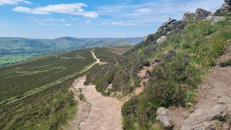
Once you’ve reached the top, follow the path along the edge, there are two paths, one slightly higher up but you can select either as you follow the edge along the top. After about 600 m from the rocks at the top of the edge, you’ll cross a gully then keep walking for another 1.4 km (approx 20 mins) which is where the path splits and you take the left-hand route which gradually heads downhill, known as Ringing Roger path.
Stage 4 – Ringing Roger to Edale Station
Distance: 1.7 miles/2.8 km
Grid reference SK 1295 8738

Once you begin descending Ringing Roger route, you’ll notice several different paths which intersect, keep to the left-hand paths and heading downhill. You’ll reach a cairn, turn left here and keep walking down the path. Towards the end the path does a few switchbacks but keep heading down until you reach the stone wall.

Go through here and walk down the grassy path until you pick up the flagstone path. Turn left and walk down until you reach some steps that take you over a wooden footbridge. Turn left down the wide track and bear right past the houses to Edale village. The path brings you out at the Nags Head, also the start of the Pennine Way route.
From here you simply follow the road through the village, past the church, round the corner and at the other end of the village there’s The Ramblers Inn pub right next to the train station.
If you’ve timed it perfectly you can jump straight on the train back to Hope or if not pop in the pub for a post-walk drink!
Do you have any more questions about this hike? Ask me in the comments below.
More options for this walk
Extend the walk
Fancy a longer route, we have a huge walk that begins in Hope and takes you around all the surrounding hills of the Hope Valley above Edale.
Read more about here:
More walks in the Peak District
Love the walks in the Dark Peak Area of the Peak District?
- Langsett Reservoir, Margery Hill + Outer Edge Trig From Langsett Barn | 13-Mile Route
- Featherbed Moss, Holme Moss (Black Hill) + Hey Edge Trig Walk From Crowden | 11-Mile Route
- Derwent Edge Walk From Ladybower Reservoir (Fairholmes) | 10-Mile Route
*Peak District Walks participates in the Amazon Services Associates Programme, as well as other affiliate programmes. If you purchase through these, Peak District Walks earn from the qualifying links. This is at no extra cost to you. Read more here.
Peak District Walks is a FREE online resource. Are you enjoying the walks? You can say thank you and buy me a coffee here. Thank you very much 🙂
Peak District charity patches
Read about the charity here.


Charity Patches

Charity Patches

Charity Patches

Charity Patches
Charity Patches

Charity Patches
Need more help planning your Peak District trip?
Join our Peak District walks Facebook page, follow us on Instagram and Twitter for inspiration.
More information on the Peak District, including transport options, where to stay, best Peak District pubs + other useful resources.
Check out the 7 YHAs in the Peak District and find the best walks direct from your accommodation.
Find out what maps you will need for your trip here.
Top tips - Read our useful guides on hiking tips here.
Guided Walks with an introduction to map reading (see dates here).
Visit our hiking recommendations page, (footwear, clothes + kit).
Or get in touch and I will help as best I can :).
Please note 'Peak District Walks' accepts no liability for any injuries or accidents resulting from walking our routes. We always recommend you wear appropriate footwear to avoid injuries and to take a paper map and compass on your walks. Read more here.