Here’s a real treat of a walk, a short 2-mile route with one of the best views in the Peak District. You can’t go wrong with that!
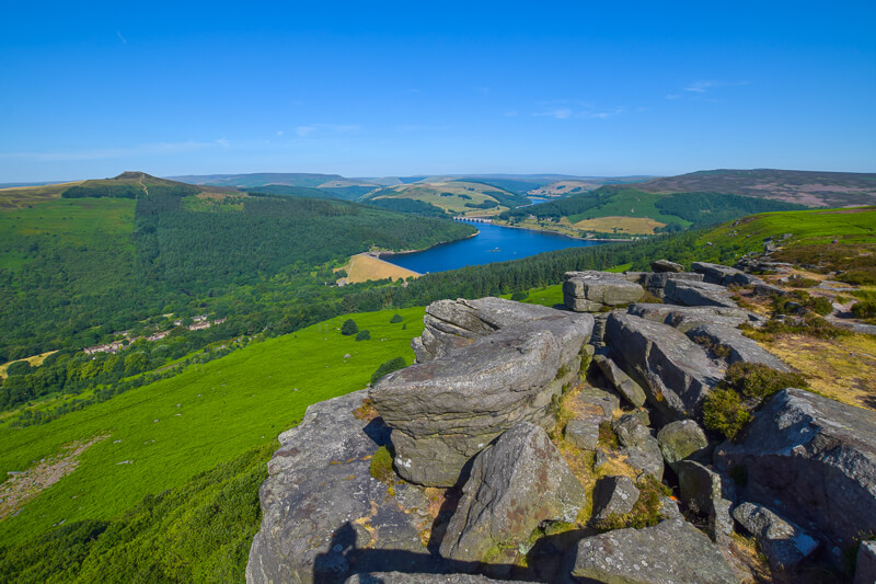
Bamford Edge walk is a lovely route, it’s a short uphill hike at the start, then you walk towards the edge and are greeted with the most beautiful views of Ladybower Reservoir nestled between the hills.
Directly opposite Bamford Edge, you’ll also see another great lookout point, Win Hill. But the Bamford Edge walk wins for me as it’s shorter and the views are more stunning!
Here you will find details on how to get to the start of the walk, route information, plus a detailed step-by-step guide of the walk.
Let me know in the comments what you think of the walk!
Buy a printable/downloadable PDF route guide for the walk here or ALL our 2-mile walk routes PDF bundle here.
Bamford Edge from Bamford

Walk information + GPX
Walk type: Short circular walk
Distance: 1.9 miles/3.1 km
Walk time: 1-1.5 hours
Total ascent: 217 m/712 ft
Highest point: 416 m/1,365 ft
Walk highlights: Bamford Edge with views to Win Hill and Ladybower Reservoir
Trigs: 0
Ethels: 0
Stiles:
Bamford Edge walk map

© Crown copyright and database rights (2024) OS 002572460
Click for OS online mapWalk start point
Start grid reference: SK 21547 83946
Car parking location: New Road, Bamford, Hope Valley, S33 0AD
This is a fairly narrow road so worth popping your wing mirrors in, also there’s only a limited amount of space near the start of the walk so you may need to park further up the road if it’s busy.
Parking Cost
Free street parking
Public transport
Nearest train station: Bamford train station (2 mile/3 km)
The train station is located on the south side of Bamford, which means the length of your walk would double by simply walking from the train station.
Facilities on the walk
No public toilets are available at the start of the walk; however, there are public toilets in Bamford, about 1 km away.
Alternatively, you could pop into the Anglers Rest, a community-owned pub, cafe and post office. It’s absolutely lovely in there, perfect to treat yourself to a good meal before or after your walk.
Other useful information
Bamford Edge can be a popular location at sunset. If you prefer quieter spots, you can either visit on a weekday or alternatively, if you walk a little way down the edge you can find a few good spots to sit and enjoy the sunset.
I’d recommend taking a drink and snacks so you have a reason to stay longer and take in all the scenery!
Peak District weather
Check the weather for your walk location and hills. We’d recommend that you check a few resources and for hill walks look at the weather conditions in the valley and on the hilltop as they can greatly vary.
- BBC Weather for Bamford
- Met Office weather for Win Hill (nearest hill to Bamford Edge)
- Met Office weather and/or MWIS (Mountain weather information service) for the Peak District
Ordnance Survey Walk Map
The map for this walk is the Ordnance Survey OL1 – Peak District (Dark Peak Area).
View the different prices here with Ordnance Survey or Amazon. If you’re hiking in all weather the Active OS maps are good to have as they are laminated so better on rainy days.
And don’t forget your compass, I recommend the Silva Expedition or the Silva Classic compass.
For online maps, I recommend OS Online App (I have been using it for many years and it is worth getting if you want to start walking more). Check prices here for the one-month or annual option with OS Online App. All the walks on the website are created using OS Online + you can download them to the App.
See both maps that cover the Peak District here.
Want to learn more map skills? Check out our Guided Walks with map reading skills here.

Check prices here for the one month or yearly option with OS Online App.
Bamford Edge is a stunning viewpoint in the Peak District. Our patch captures the view from Bamford Edge looking towards Ladybower Reservoir. Order your patch below.
Charity Patches
Bamford Edge patch

Want to read later? Save the walk to Pinterest

Buy a printable/downloadable PDF route guide for the walk here or ALL our 2-mile walk routes PDF bundle here.
Bamford Edge walk route
Stage 1 – Bamford New Road to Bamford Edge
Distance: 0.9 miles/1.5 km
Grid reference SK 21547 83951
Begin the walk from New Road, go over the stile to get onto the footpath. There are two routes to the top, on the way up take the more obvious path straight in front of you.
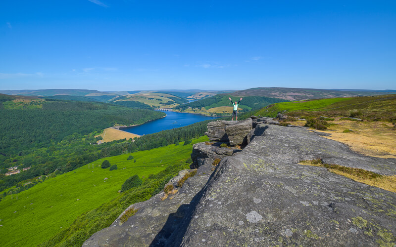
It’s a steep but short climb to the top, where you’ll reach a path that will take you all the way to the edge overlooking Ladybower Reservoir and beyond to the beautiful Derwent Edge.

There are some huge flat rocks, known as Great Tor – it’s obvious when you’ve arrived because the view speaks for itself.
Take your time and enjoy the views, depending on how much time you have you can increase your walk by walking further down the edge.

Stage 2 – Bamford Edge to Bamford New Road
Distance: 0.9 mile/1.5 km
Grid reference SK 20732 85089
After you’ve taken all your photos get ready to head down.
Instead of returning on the same path, follow the route back keeping close to Bamford Edge on your right. This takes you on a slightly different path, closer to the edge.
The path curves round to the left and at this point, you can then opt for a more gradual route down as the path starts to descend, parallel to the road where you parked at the beginning.
Then before you know it you’re back at the start!
Do you have any more questions about the Bamford Edge walk? Ask me in the comments below.
Buy a printable/downloadable PDF route guide for the walk here or ALL our 2-mile walk routes PDF bundle here.
Short walks in the Peak District
- 8 Beautiful Short Walks in the Peak District
- Robin Hood’s Stride | 4.5-Mile Route
- Middle Black Clough Waterfall Walk | 2-Mile Route
Or check out all our Peak District walking routes here
Save me to your Hiking boards on Pinterest


*Peak District Walks participates in the Amazon Services Associates Programme, as well as other affiliate programmes. If you purchase through these, Peak District Walks earn from the qualifying links. This is at no extra cost to you. Read more here.
Peak District Walks is a FREE online resource. Are you enjoying the walks? You can say thank you and buy me a coffee here. Thank you very much 🙂
Peak District charity patches
Read about the charity here.


Charity Patches

Charity Patches

Charity Patches

Charity Patches

Charity Patches

Charity Patches
Need more help planning your Peak District trip?
Join our Peak District walks Facebook page, follow us on Instagram and Twitter for inspiration.
More information on the Peak District, including transport options, where to stay, best Peak District pubs + other useful resources.
Check out the 7 YHAs in the Peak District and find the best walks direct from your accommodation.
Find out what maps you will need for your trip here.
Top tips - Read our useful guides on hiking tips here.
Guided Walks with an introduction to map reading (see dates here).
Visit our hiking recommendations page, (footwear, clothes + kit).
Or get in touch and I will help as best I can :).
Please note 'Peak District Walks' accepts no liability for any injuries or accidents resulting from walking our routes. We always recommend you wear appropriate footwear to avoid injuries and to take a paper map and compass on your walks. Read more here.
Pingback: Bamford Edge – ScHARR Green Impact Wellbeing Walks
Pingback: 4 Days in Peak District, England-14 Awesome Things to do
Pingback: Win Hill + Crook Hill Walk From Ladybower Reservoir | 9-Mile Route - Peak District Walks
Pingback: 16 Stunning Sunset Walks In The Peak District - Peak District Walks
Pingback: Win Hill + Kinder Plateau Walk From Hope To Edale | 9-Mile Route - Peak District Walks
Pingback: Stanage Edge, Derwent Edge + Ladybower Reservoir Walk From Bamford | 14-Mile Route - Peak District Walks
Pingback: Thor's Cave Short Walk From Wetton | 3.5-Mile Route - Peak District Walks
Pingback: 15 BEST Walks in the Peak District - Peak District Walks
Pingback: River Derwent Short Walk From Hathersage | 5-Mile Route - Peak District Walks
Pingback: 16 Beautiful BEST Short Walks in the Peak District – Peak District Walks
Pingback: Crook Hill Walk From Ladybower Reservoir | 4-Mile Route – Peak District Walks