
Here’s a fantastic waterfall walk you can do in the Peak District. Middle Black Clough waterfall is a short but challenging walk – if you enjoy an adventure then this is the walk for you.
The waterfall is located on a clough hidden away from the road, not too far from Crowden. On the way, you explore the beautiful woodland whilst following the clough into this remote part of the Peak District.
You’ll need to be prepared for this walk as there’s a water crossing, so bring your wellies, and there’s also a small amount of scrambling. (Read other information for more details).
Here you will find details on how to get to the start of the waterfall walk, a map and GPX file, route information, plus a detailed step-by-step guide of the walk.
Have you done any waterfall walks in the Peak District? Let me know in the comments.
Buy a printable/downloadable PDF route guide for the walk here or ALL our 2-mile walk routes PDF bundle here.
Middle Black Clough near Crowden

Walk information + GPX
Walk type: Short linear walk (with scrambling)
Distance: 2 miles/3.3 km
Walk time: 1-1.5 hours
Total ascent: 180 m/590 ft
Highest point: 352 m/1,155 ft
Walk highlights: Following the path up Middle Black Clough + the Middle Black Clough Waterfall
Trigs: 0
Ethels: 0
Stiles: 0
Middle Black Clough waterfall walk map

© Crown copyright and database rights (2024) OS 002572460
Click for online mapWalk start point
Start grid reference: SK 11141 99937
Car parking address: Woodhead Road, near Woodhead Reservoir, Glossop, SK13 1JE – Google location

Please note – this is not the exact postcode for the location, but will get you to near the location on the A628 road. Here’s the pinned location for the parking.
There are three small lay-bys just off the A628 where you can park for free on this walk.
Public transport
There are no public transport options for this walk
Facilities on the walk
There are no public toilets available at the start of the walk. The nearest pub after or before your walk is the Bull’s Head at Glossop.
Water on your walk – I recommend a filter water bottle for your Peak District walks, it saves you from carrying extra weight and you can fill up safely and drink water from the streams on your walk.
Other useful information
If you’re visiting a waterfall in the Peak District they are always more impressive after we’ve had some rain; however, this does mean the water crossing can be higher and trickier.

The day I did the walk, it had been raining in the days prior so the water crossing was deep. I also met a family with small children (in wellies) who walked across the ford. Why do kids always have cooler wellies – I want adult crocodile ones like these!
Wearing hiking boots I opted to hike further up and cross at a shallower point, using rocks as stepping stones, but this then means you have a second crossing, further along, to get on the right side of the clough.
Looking for some waterproof hiking boots? Cotswold Outdoor has a fab range and there are often ones in the clearance section too!
After you’ve crossed the water there’s then a short section which you need to scramble alongside the clough, it’s not too challenging.
Peak District weather
Check the weather for your walk location and hills. It’s worth checking the weather for rain prior to your walk, if it’s been raining too much it might not be safe to cross.
- BBC Weather for Crowden
- Met Office weather for Crowden in Longdendale
- Met Office weather and/or MWIS (Mountain weather information service) for the Peak District
More waterfall walks
Do you love exploring the Peak District waterfalls? After this walk check out our other brilliant walks where you can see pretty waterfalls in the Peak District – 15 Beautiful Peak District Waterfalls

15 BEST Peak District Waterfalls (+ Walks to Visit Them)
How many beautiful Peak District waterfalls have you visited on your walks? The Peak District National Park has waterfalls hidden all over it, from very obscure places to popular well-known locations. [...]
read hereOrdnance Survey Walk Map
The map for this walk is the Ordnance Survey OL1 – Peak District (Dark Peak Area).
View the different prices here with Ordnance Survey or Amazon. If you’re hiking in all weather the Active OS maps are good to have as they are laminated so better on rainy days.
And don’t forget your compass, I recommend the Silva Expedition or the Silva Classic compass.
For online maps, I recommend OS Online App (I have been using it for many years and it is worth getting if you want to start walking more). Check prices here for the one-month or annual option with OS Online App. All the walks on the website are created using OS Online + you can download them to the App.
See both maps that cover the Peak District here.
Want to learn more map skills? Check out our Guided Walks with map reading skills here.
Check prices here for the one month or yearly option with OS Online App.
Want to read later? Save the walk to Pinterest

Buy a printable/downloadable PDF route guide for the walk here or ALL our 2-mile walk routes PDF bundle here.
Middle Black Clough waterfall walk route
Stage 1 – A628 parking layby to Middle Black Clough waterfall
Distance: 1 miles/1.6 km
Grid reference SK 11132 99948
From the parking lay-by, on the far side of the road, head east up the road, away from Woodhead Reservoir, where you can see it bend around to the right.
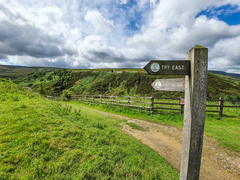
Cross over the road and down a track, fingerpost sign for TPT West (Trans Pennine Trail). At the bottom, turn right then follow the path around and over the River Etherow. Now follow this path with the river on your left, you’ll go past a small waterfall on the walk.
After 500 metres, you’ll reach a ford across the clough, ignore this and keep heading up the rocky path into the woods. After the first crossing, it’s another 400 metres until the next point to cross.
It’s a wide crossing and depending on the water level you’ll need to pick the best route across (wellies advisable).

Once safely across, you then follow the clough all the way up the rocky path until you reach the waterfall – you can’t miss it!
Note – at the crossing, there is a narrow path heading uphill, this is really steep and exposed in places but you can follow this and find a narrower place to cross (if you didn’t bring wellies). You’ll then need to navigate through the terrain on the other side and do a second water crossing.

Stage 2 – Middle Black Clough waterfall to A628
Distance: 1 mile/1.6 km
Grid reference SK 11619 99010

Once you’ve had fun exploring the waterfall, from below and above, the best way back down is via the same route along the clough.
There are not many options to extend this loop other than doing a much longer walk up to Bleaklow. See details below.
Let me know if you have any questions about this waterfall walk
Buy a printable/downloadable PDF route guide for the walk here or ALL our 2-mile walk routes PDF bundle here.
Other options for this walk
Extend the walk
If you continue heading uphill from this waterfall you end up on Bleaklow, but this section is very hard to navigate and it’s easy to get lost and spend hours up there as there are not many features.
I’d recommend if you want to do a longer walk to head back down from the waterfall then go back up via Near Black Clough, you can follow this path up to Bleaklow, pick up the Pennine Way to Torside Reservoir. And then take the Longendale Trail alongside Torside Reservoir and Woodhead Reservoir back to the start.
This walk is 11 miles/18 km, plus the extra section up to the waterfall and back down.
Bleaklow longer walk – route map here
More walks in the Peak District
Do you love waterfalls? You might like these waterfall walks in the Peak District.
- Three Shires Head Walk from Gradbach (Waterfall Walk) | 8-Mile Route
- Edale to Crowden (via the Pennine Way) | 17-Mile Route – (Kinder Downfall)
More waterfall walks coming soon – sign up below to get all our new routes.
Or check out all our Peak District walking routes here
Save me to your Hiking boards on Pinterest


*Peak District Walks participates in the Amazon Services Associates Programme, as well as other affiliate programmes. If you purchase through these, Peak District Walks earn from the qualifying links. This is at no extra cost to you. Read more here.
Peak District Walks is a FREE online resource. Are you enjoying the walks? You can say thank you and buy me a coffee here. Thank you very much 🙂
Peak District charity patches
Read about the charity here.


Charity Patches

Charity Patches

Charity Patches

Charity Patches

Charity Patches

Charity Patches
Need more help planning your Peak District trip?
Join our Peak District walks Facebook page, follow us on Instagram and Twitter for inspiration.
More information on the Peak District, including transport options, where to stay, best Peak District pubs + other useful resources.
Check out the 7 YHAs in the Peak District and find the best walks direct from your accommodation.
Find out what maps you will need for your trip here.
Top tips - Read our useful guides on hiking tips here.
Guided Walks with an introduction to map reading (see dates here).
Visit our hiking recommendations page, (footwear, clothes + kit).
Or get in touch and I will help as best I can :).
Please note 'Peak District Walks' accepts no liability for any injuries or accidents resulting from walking our routes. We always recommend you wear appropriate footwear to avoid injuries and to take a paper map and compass on your walks. Read more here.
Pingback: Laddow Rocks + Black Hill via Pennine Way From Crowden | 9-Mile Route - Peak District Walks
Pingback: Waterfalls In England: 12 Breathtaking Spots To Visit
Pingback: Three Shires Head Walk from Gradbach (Waterfall Walk) | 8-Mile Route - Peak District Walks
Pingback: Langsett Reservoir Short Walk From Langsett | 4-Mile Route - Peak District Walks
Pingback: 15 BEST Peak District Waterfalls (+ Walks to Visit Them) - Peak District Walks
Pingback: The Best Waterfalls To Visit In The UK
Pingback: 16 Beautiful BEST Short Walks in the Peak District – Peak District Walks