Thor’s Cave walk is located in the Manifold Valley in the Staffordshire Peak District. It is a brilliant route to do with friends and family, including little ones looking for some adventure on a walking route!
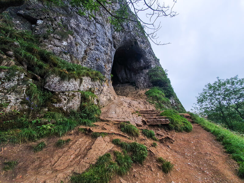
Thor’s Cave is a huge cave that you can go inside and explore further, plus there are stunning views of the Manifold Valley from the cave entrance.
From Wetton, this short walking route takes you first to explore Thor’s cave, then heads down along the Manifold Valley and loops back round past Wetton Mill, where you can find more caves to explore. Then you head across fields near Wetton Hill before returning back to Wetton village.
Here you will find details on how to get to the start of the walk, where to park in Wetton, route information, map, GPX file, plus a detailed step by step guide of the walk.
The Peak District has many wonderful caves you can explore, from the larger caves like Blue John Cavern, Peak Cavern and Speedwell Cavern where you can take tours to go deep underground. But there are also a few great caves you can find whilst on walks too.
Let me know in the comments if you’ve done this Thor’s Cave walk and what you think!
Buy a printable/downloadable PDF route guide for the walk here.
We also have another Thor’s Cave walk from Wetton, if you’re looking for something shorter – 3.5-mile Thor’s Cave walk here.
Thor’s Cave Walk from Wetton

Walk information + GPX
Walk type: Short Circular Walk
Distance: 4.7 miles/7.5 km
Walk time: 2-3 hours
Total ascent: 343 m/1,125 ft
Highest point: 335 m/1,099 ft
Walk highlights: Thor’s Cave + other caves, Manifold Valley and Wetton Mill
Trigs: 0
Ethels: 0
Stiles: 7
Thor’s Cave + Manifold Valley walk map

© Crown copyright and database rights (2024) OS 002572460
Click for online map
Walk start point
Start grid reference: SK 10899 55140
Car parking address: Wetton car park, Carr Lane, Wetton, Ashbourne, DE6 2AF – Google location

This a small free car park, however, during peak times there is a second overflow car park, simply follow the signs for free parking through Wetton village.
Please remember this is a small village so please have an alternative plan if the parking is full when you arrive. View our Walk locations for other places to visit.
Public transport
Nearest train station: Stoke-on-Trent train station (20 miles/32 km)
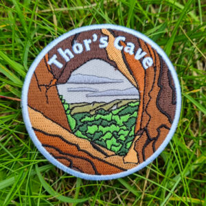
Unfortunately, there are no bus services to the start point in Wetton. Thor's Cave is a brilliant place to explore in the White Peaks area and now you can celebrate with your own patch. Our patch captures the view looking out from Thor's Cave to the Manifold Valley. Order your right here:
Charity Patches
Thor's Cave patch
Facilities on the walk
There are public toilets available at the start of the walk at Wetton and also a second set of toilets near Wetton Mill.
Wetton has a lovely pub – The Royal Oak, perfect to visit after your walk or alternatively if you time it right there are Wetton Village Hall has a Tea Room for a cake at the end of your walk! Or if you fancy a stop halfway around the walk Wetton Mill has a small cafe too!
Water on your walk – I recommend a filter water bottle for your Peak District walks, it saves you from carrying extra weight and you can fill up safely and drink water from the streams on your walk.
Other useful information
Thor’s Cave route is a popular place to visit in the Staffordshire Peak District, I’d recommend going mid-week or an evening when it’s quieter and you can enjoy the cave to yourself.
Also as many people visit the cave the limestone rock at the entrance/exit has become very smooth with the number of people walking into it, please be careful – I recommend going on your bum for a safer option.
And finally, Thor’s Cave is a large cave, so it’s worth taking a headtorch, like this Petzl one, to explore the back of the cave so you have your hands free to get safely around.
Rainy days – The first section of this route can be very muddy (and slippy). Make sure you’ve got good footwear and also clothes you don’t mind getting muddy. Gaiters are pretty good for this route to save your trousers/leggings from getting covered in mud splashes!
Please keep the Peak District beautiful and respect everyone who uses the park. Take ALL your rubbish home to dispose of and remember close gates (as you found them). Thank you so much.
Would you know what to do in an emergency situation?

We have a guide with what to do, who you need to call and also some useful kit that should be in your backpack. Ask us any questions in the comments or via our social media.
Happy hiking + stay safe
read hereCheck the weather for your walk location and hills
- BBC Weather for Wetton, Staffordshire
- Met Office weather and/or MWIS (Mountain weather information service) for the Peak District
- Met Office weather for Manifold Valley
Ordnance Survey Walk Map
The map required for this walk is the Ordnance Survey OL24 – Peak District (White Peak Area). Check prices here with Ordnance Survey or Amazon. If you’re hiking in all weather the Active OS maps are good to have as they are laminated so better on rainy days.
View both Peak District map options here.
And don’t forget your compass, I recommend the Silva Expedition or the Silva Classic compass.
For online maps, I recommend OS Online App (I have been using it for many years and it is worth getting if you want to start walking more). Check prices here for the one-month or annual option with OS Online App. All the walks on the website are created using OS Online + you can download them to the App.
See both maps that cover the Peak District here.
Want to learn more map skills? Check out our Guided Walks with map reading skills here.
Want to read later? Save the walk to Pinterest

Thor’s Cave + Manifold Valley walk route
Buy a printable/downloadable PDF route guide for the walk here.
Stage 1 – Wetton car park to Thor’s Cave
Distance: 0.8 miles/1.3 km
Grid reference SK 10896 55125
From the smaller part of the car park, go over the stone stile and across the field and through a narrow footpath to the road. Turn left and walk down the road, as the road splits take the right-hand fork down a track, signposted ‘Concession Path to Thor’s Cave’.
Go over the stone stile and continue down the track until you reach another stone stile that takes you into a field, keep to the left-hand side of the field and walk towards the hill in the distance (this is where Thor’s Cave is located).

Walk down the narrow footpath across the field until you reach a small wooden gate, go through here then follow the path down to the entrance of Thor’s Cave.
The entrance to the cave is sloped, so take your time as you enter, then you can pop on your head torch and explore further towards the back.

Stage 2 – Thor’s Cave to Wetton Mill
Distance: 1 mile/1.5 km
Grid reference SK 09891 54968
Once you’ve finished exploring, leave Thor’s Cave in the same way but taking more care as the slippy rocks make it more like a slide and even more so if it’s been raining.

Turn right and follow the steps descending from the cave, after a few hundred metres the path splits, take the left-hand path which is a steeper descent but takes you down to the river bed through the trees. Cross the bridge and turn right along the wide footpath.
Follow the path as it runs parallel to the river (mostly dry) until a second bridge. Cross over and turn right through a wooden gate into the valley, signposted Wetton Hills (photo below).

Walk for 500 metres, as the path bends to the right look for a Public Bridleway signpost which is almost hidden in the trees, this is where you turn left and head up the path. Go through the gate, then as the path opens out at an open space. Follow the wooden signpost right taking you towards a second cave.
The cave is above Wetton Mill, there are two caves here to explore, a larger one and a smaller tunnel cave, which is pretty cool to explore.

Stage 3 – Wetton Mill to Wetton Hill
Distance: 2 miles/3.3 km
Grid reference SK 09543 56101
After exploring the caves, follow the path back then head down to Wetton Mill. Then turn right and head down the track to Dale Farm, walk through the farm and through a gate.

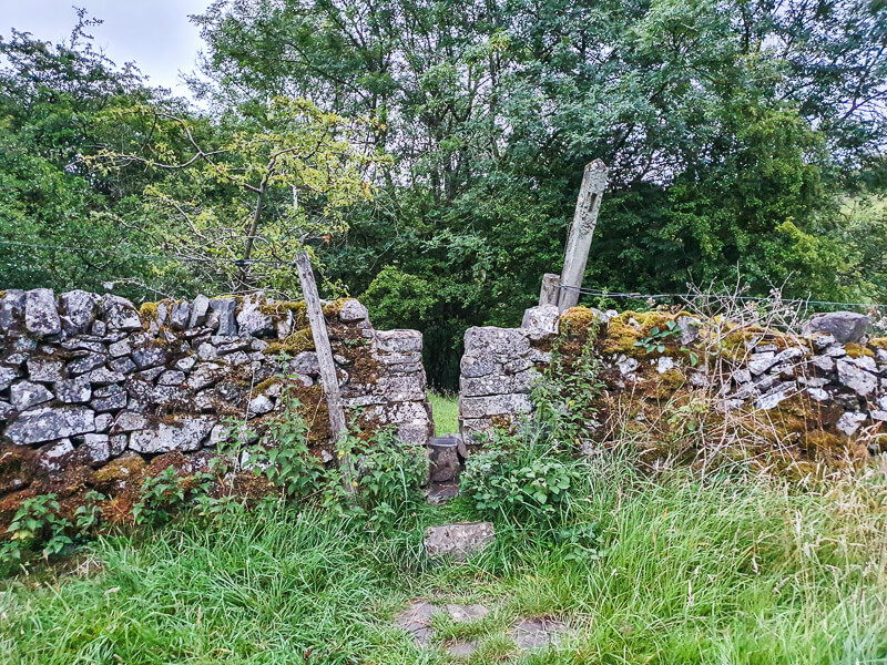
Head across the open space then continue walking up a stone path that goes uphill to a wooden stile, then a second stone stile (photo below). Bear left and then continue down the path with the hedges on the right.
Go through a gate, keep walking to a second gate then turn right onto the road for about 500 metres. The road bends round to the left then goes past a house. Shortly after, take the footpath through the stile on the left (in the corner, which can be hidden by trees), walk down across the stream via the rocks and up across the hills.

Stage 4 – Wetton Hill to Wetton
Distance: 1 mile/1.5 km
Grid reference SK 10744 56391
Keep walking up the boundary line the bear right continuing uphill. Go over the wooden stile and head south across the field, away from the boundary wall towards a second wooden stile across the field. Walk uphill on the track, then across to a small wooden gate.
Walk until you reach a stone stile, go over here, then to another wooden gate and out onto the road. Walk straight down the road, past the pub and then turn right and walk down the road back to the car park.
Let me know in the comments if you’ve done this Thor’s Cave walk and what you think!
Buy a printable/downloadable PDF route guide for the walk here.
More walks in the Peak District
Love the walks in the White Peaks? You might like these Peak District circular walks.
- Shutlingsloe Walk from Wildboarclough
- Dovedale Walk (Bunster Hill + Thorpe Cloud)
- Wolfscote Dale + Biggin Dale walk from Hartington
Or check out all our Peak District walking routes here
Save me to your Hiking boards on Pinterest


*Peak District Walks participates in the Amazon Services Associates Programme, as well as other affiliate programmes. If you purchase through these, Peak District Walks earn from the qualifying links. This is at no extra cost to you. Read more here.
Peak District Walks is a FREE online resource. Are you enjoying the walks? You can say thank you and buy me a coffee here. Thank you very much 🙂
Peak District charity patches
Read about the charity here.


Charity Patches

Charity Patches

Charity Patches

Charity Patches

Charity Patches

Charity Patches
Need more help planning your Peak District trip?
Join our Peak District walks Facebook page, follow us on Instagram and Twitter for inspiration.
More information on the Peak District, including transport options, where to stay, best Peak District pubs + other useful resources.
Check out the 7 YHAs in the Peak District and find the best walks direct from your accommodation.
Find out what maps you will need for your trip here.
Top tips - Read our useful guides on hiking tips here.
Guided Walks with an introduction to map reading (see dates here).
Visit our hiking recommendations page, (footwear, clothes + kit).
Or get in touch and I will help as best I can :).
Please note 'Peak District Walks' accepts no liability for any injuries or accidents resulting from walking our routes. We always recommend you wear appropriate footwear to avoid injuries and to take a paper map and compass on your walks. Read more here.
Pingback: Thor's Cave Short Walk From Wetton | 3.5-Mile Route - Peak District Walks
Pingback: Magpie Mine Short Walk From Ashford-in-the-Water | 5.5 Mile Route - Peak District Walks
Pingback: 12 BEST Walks in the Peak District - Peak District Walks