
A lovely circular walk from Hayfield, including a couple of ‘Ethels‘ and trig points on the way as well as walking past one of the numerous plane crash sites in the Peak District.
From Hayfield, you begin by heading up towards Kinder Reservoir. Then you begin your ascent via William Clough. This is a large part of the uphill on the walk so take your time. Once you reach the top of the William Clough, on your right you’ll have a fantastic view of the westerly edge of the Kinder Plateau, but here you’ll turn left following the path up to Mill Hill.
A short distance from Mill Hill summit, to the right of the flagstoned path, you’ll walk past the remains of the B-24 Liberator crash site, worth a stop to explore. Continue down the path where you’ll veer off to Harry Hut trig point then head down to go across the A624.
It’s then across fields until you pick up the Pennine Bridleway which takes you to the base of Lantern Pike and it’s a short hike to the top. From the summit you head down, again joining the Pennine Bridleway back through the town of Hayfield and alongside the River Sett back to the start.
Here you will find details on how to get to the start of the walk at Hayfield, route information, map, GPX file, plus a detailed step by step guide of the walk.
Let me know in the comments if you’ve done this walk from Hayfield and what you think!
Fancy a shorter walk from Hayfield? Try this 7-mile route up Mount Famine and South Head (both Peak District Ethels)
Harry Hut + Lantern Pike Trigs from Hayfield

Walk information + GPX
Walk type: Medium circular walk
Distance: 9.8 miles/15.7 km
Walk time: 4.5-5.5 hours
Total ascent: 600 m/1,968 ft
Highest point: 544 m/1,784 ft
Walk highlights: Kinder Reservoir, William Clough, views of Kinder Plateau, B-24 Liberator crash site, Harry Hut trig + Lantern Pike
Trigs: 2 – Harry Hut + Lantern Pike
Ethels: 2 – Mill Hill + Lantern Pike
Stiles: 8 (mostly stone stiles)
Harry Hut + Lantern Pike Trig walk map
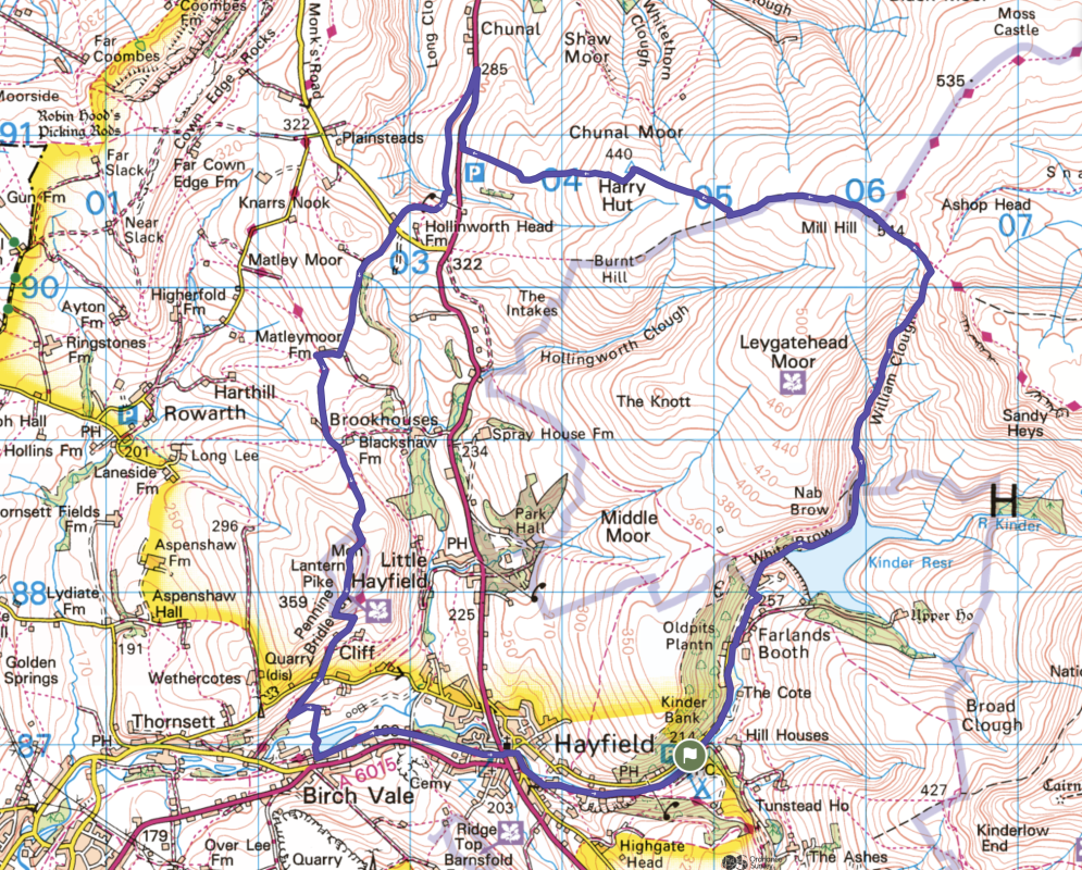
© Crown copyright and database rights (2024) OS 002572460
Walk start point

Start grid reference: SK 04856 86921
Car parking address: Bowden Bridge car park, 165 Kinder Road, Hayfield, High Peak, SK22 2LH – Google maps
This is a small car park which can get busy during peak times. Alternatively, there’s some street parking available on the road with the Sportsman pub.
Parking cost – cash only (9 am to 6 pm)*
- Up to 1 hour – £1.50
- 1-2 hours £2.50
- 2-4 hours £4.00
- All day £4.75
There’s a second larger car park on the route just outside of Hayfield, this would mean you start your walk at Stage 4.
Hayfield pay and display car park
Parking cost – cash only*
(Charges – 9 am to 5 pm or 8 am to 8 pm – depending on time of year)
- Up to 2 hours – £2.50
- 2-4 hours £4.50
- All day £7.00
*Prices correct at time of writing
There’s also a small parking lay-by on the A624 at the point where you cross the road; however there are no other facilities near here.
Public transport
Nearest train station: Glossop train station (6 miles/10 km)
From Glossop train station you can then catch the no. 61 bus (High Peak service) from Glossop to Hayfield bus station, so you can begin the route from there alongside the River Kinder (about a mile from Bowden Bridge car park).
Facilities on the walk

There are public toilets available at the start of the walk at Bowden Bridge, Hayfield, a small block opposite the car park at the entrance to Hayfield Campsite and also toilets at Hayfield car park, although this is almost at the end of the walk.
In Hayfield there are a couple of pubs and also a tea rooms if you fancy a treat after your walk.
Other useful information
There’s a road to busy cross on the walk (A624) please take care when crossing.
The section across to Harry Hut trig point can be extremely boggy in places, it’s worth wearing good footwear in wet weather to keep your feet dry!

Peak District weather
The weather can vary widely from Hayfield town to the top of the hills so please check the conditions and make sure you have warm/waterproofs if necessary.
- BBC Weather for Hayfield
- Met Office weather for Kinder Low (nearest high point)
- Met Office weather and/or MWIS (Mountain weather information service) for the Peak District
Ordnance Survey walk map
The map for this walk is the Ordnance Survey OL1 – Peak District (Dark Peak Area). Check prices here with Ordnance Survey or Amazon. If you’re hiking in all weathers the Active OS maps are good to have.
See both Peak District maps here.
And don’t forget your compass, I recommend the Silva Expedition or the Silva Classic compass.
For online maps, I recommend OS Online App (I have been using for many years and it is worth getting if you want to start walking more). Check prices here for the one month or annual option with OS Online App. All the walks on the website are created using OS Maps Online + you can download them to the OS Maps App.
Win Hill patch
A stunning view from Win Hill summit complete with trig point, looking towards the Derwent Valley and Ladybower Reservoir. Have you climbed this hill? Treat yourself to the patch! Or if you are planning on doing the Win Hill walk soon, order a patch so you can take it to the top for a photo. visit shop
Charity Patches
Harry Hut + Lantern Pike walk route
Stage 1 – Hayfield to William Clough
Distance: 1.6 miles/2.5 km
Grid reference SK 04856 86921
From Bowden Bridge car park turn left and head along Kinder Road which runs next to the River Kinder. It’s a quiet road with little traffic so you can walk on the road. Keep walking until you reach two gates, go through the wooden gate, leading to access land and begin your uphill ascent.
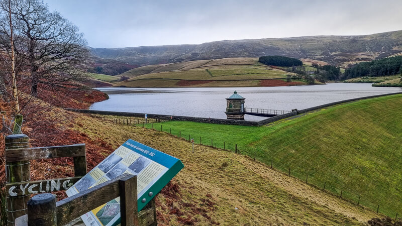
Continue walking until Kinder Reservoir comes into view on your right. Go through a gate and take the footpath bearing left, follow this path as it takes you down next to the stone wall next to the reservoir. On your right you can see the Kinder Plateau high above.
The path curves round to the left then brings you out at the top of the reservoir near a small bridge, which is also the start of William Clough.
Stage 2 – William Clough to Harry Hut trig
Distance: 2.4 mile/3.8 km
Grid reference SK 05965 88718
Don’t cross the bridge, instead begin your ascent up William Clough next to the small signpost. It’s a narrow path that heads up the clough and often splits off into different paths, crossing back and forward across the water but they all link back up so pick the route you’re most comfortable with.
In terms of distance, it’s about 1.5 km, but the steep (200 metres ascent) and windy path means it’ll take you longer than you think!

Towards the top you’ll go up some steps before it brings you out where the path splits, take the left-hand path that brings you out next to the main footpath and a green signpost.
Turn left here, following the signpost towards Bleaklow via the Pennine Way, after a short distance you’ll reach a small cairn which is the summit of Mill Hill (one of the Ethels). From here, keep walking straight on, picking up the flagstone path. A short distance after you’ve joined this section, you’ll come across the B-24 plane crash site on your right.

Continue on the flagstoned path for about 1 km, ignore the first footpath you see veering off on the right, instead take the second one. When I walked the route, the turning was where the flagstones had sunk slightly into the peat.
From a flagstoned section this route can be boggy in places so find your best way across, you should be able to see Harry Hut trig point in the distance. It’s about 600 m across this section and the trig point!

Stage 3 – Harry Hut trig to Lantern Pike
Distance: 3 miles/4.8 km
Grid reference SK 0447 9077
At Harry Hut trig point, turn left here (not the more obvious path straight ahead). Follow for about 600 m to a stone wall, go though the small wooden gate and continue walking down towards the main road.
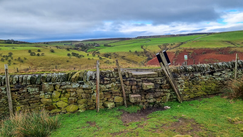
Here’s where your first stone stile on the walk is over the wall (photo above). Once over the wall, turn right along the road for around 400 yards, until you see a footpath sign on the opposite side. This road can be busy and cars travel quickly on it, so please be careful. Cross to the footpath and turn left up it, picking up the path through fields and towards the telegraph pole and tree in the distance.
You’ll reach another wall, go over the stone stile and a small stream. Head uphill, towards the top you’ll see another stone stile in the wall on the left (ignore this) and walk towards the wall, to the right you’ll see another stone stile, immediately followed by a metal gate, go this way! (Photo below)

Walk along the path, towards the farmhouses, you’ll go over another stone stile, a metal gate, then through a wide gate (or over the wooden stile if the gate is locked), another wooden gate and finally a stone stile bringing you out on the road.
Cross the road and head up the track, signposted public footpath. Walk up here until the path splits and take the grassy track on the left. Walk all the way along here, then over a stone stile, keeping the wall on your left until you reach another wooden stile next to a gate in the corner of the field.

Walk down and turn right at the track, after about 200 m you’ll reach the Pennine Bridleway, turn left and follow until you reach a gate with numerous signposts! Go though the gate, following the signpost for Pennine Bridleway (Hayfield 2 1/2). The path bears right across the field and picks up the track, turn right and you’ll reach a gate (with signpost ‘Bridleway Only’).
Walk up the track, on your right you’ll see a National Trust signpost for Lantern Pike. There are currents signs with a small detour for erosion control so continue walking up the track and follow the next sign about 100 m up the track which leads you to the summit of Lantern Pike, now with a topography, not a trig, at the summit (although this is still included in the trig challenge).

Stage 4 – Lantern Pike to Hayfield
Distance: 2.9 miles/4.7 km
Grid reference SK 0261 8826

From Lantern Pike summit, begin to head down the path. On your right, on the adjacent hill if you look carefully you can see a fallen trig in the ground; add in an optional detour if you wish! Then continue down the path, following it downhill and round to the left. At the bottom turn right through the wide gate, you’re now back on the Pennine Bridleway, which you’ll stay on almost to the end of the walk.
Follow the track down to a narrow road, walk down here and as the road begins to head uphill, take the wide track on the left, signposted Pennine Bridleway and also one for Hegginbottom Farm. Walk down here and follow the road as it bends sharply to the left (past the red sign in the tree about sat nav!)

Walk down here and at the fingerpost turn right over the stone stile. Go down here through two narrow gaps then across a small bridge. Follow the path alongside the edge of the reservoir that brings you out through a gate onto a trail. Turn left here (signposted Hayfield 1 mile) and walk all the way along, keep to the left-hand path next to the car park.
Go across the road at the traffic lights, towards the church, walk past the Italian restaurant and at the road turn right (opposite Millie’s Tea Rooms). Then take the next road on the left (marked with a dead end sign and a small acorn with PBW).

Walk all the way along this road, with the River Sett on your left. Keep walking all the way through the campsite, then as you leave the campsite, turn left over the bridge and you’re back at the car park.
Note – if you’re parked on the road near the Sportsman pub you can go across the footbridge over the river and up the steps on the other side.
Ask me any questions about this walk in the comments below.
More walks in the Peak District
Love the walks in the Peak District? You might like these circular walks in the Dark Peaks.
- Arnfield Moor, Chew Reservoir + Featherbed Moss Trig Walk From Crowden | 12-Mile Route
- Blackden Brook to Kinder Plateau (Scramble + Waterfall Route)
- Dovestone Reservoir Walk (+ Trinnacles) Saddleworth | 12-Mile Route
Or check out all our Peak District walking routes here
Peak District Walks is a FREE online resource. Are you enjoying the walks? You can say thank you and buy me a coffee here. Thank you very much 🙂
Peak District charity patches
Read about the charity here.


Charity Patches

Charity Patches

Charity Patches

Charity Patches
Charity Patches

Charity Patches
Need more help planning your Peak District trip?
Join our Peak District walks Facebook page, follow us on Instagram and Twitter for inspiration.
More information on the Peak District, including transport options, where to stay, best Peak District pubs + other useful resources.
Check out the 7 YHAs in the Peak District and find the best walks direct from your accommodation.
Find out what maps you will need for your trip here.
Top tips - Read our useful guides on hiking tips here.
Guided Walks with an introduction to map reading (see dates here).
Visit our hiking recommendations page, (footwear, clothes + kit).
Or get in touch and I will help as best I can :).
Please note 'Peak District Walks' accepts no liability for any injuries or accidents resulting from walking our routes. We always recommend you wear appropriate footwear to avoid injuries and to take a paper map and compass on your walks. Read more here.
*Peak District Walks participates in the Amazon Services Associates Programme, as well as other affiliate programmes. If you purchase through these, Peak District Walks earn from the qualifying links. This is at no extra cost to you. Read more here.
Hi BECKY.,CAN I DOWNLOAD THE WALKS THAT YOU HAVE SENT ME?
Sorry, not sure what you mean, what are you wanting to download? The GPX and link to the map are already available to download on every walk on the website. Let me know and I’ll try to help