
This Blackden Brook route to Kinder Scout plateau is a short hike in terms of distance. But with tough terrain, a rocky scramble and lots of waterfalls to detour off-path to explore it will probably take you longer than you think!
If you love a more adventurous hike in the Peak District then this route is for you. However, if you’d prefer an easier route up Kinder Scout then check out the walk options from Edale.
This hike begins from Snake Pass, where you first hike up Blackden Brook, walking past a couple of waterfalls on the route and detouring off-path to reach the biggest one (if you want!) Towards the top of Blackden Brook, there’s a brilliant but challenging scramble (read ‘Other Information’) to the top of the Kinder Plateau.

Once you reach the top and often blustery summit of the Kinder Scout plateau you make your way along the edge. Before descending back down via Fairbrook, with more off-path waterfalls to explore on the way down. As you near Snake Pass and the bottom of the brook you loop back along the lower sheep path to the start of the walk.
Here you will find details on how to get to the start of the walk at Snake Pass, parking options, route information, map, GPX file, plus a detailed step by step guide of the walk.
Let me know in the comments if you’ve done this walk up to Kinder Scout north side and what you think!
Blackden Brook (scramble route) from Snake Pass

Walk information
Walk type: Medium circular walk (with Grade 1 scramble)
Distance: 6.3 miles/10.1 km
Walk time: 3-4 hours
Total ascent: 660 m/2,165 ft
Highest point: 614 m/2,014 ft
Walk highlights: Blackden Brook route + waterfalls, heather in bloom (late summer), rock scramble to top, hidden waterfalls on Fairbrook
Trigs: 0
Ethels: 0
Blackden Brook walk map

© Crown copyright and database rights (2024) OS 002572460
Walk start point

Start grid reference: SK 13015 89501
Car parking address: Layby on Snake Pass, A57 – Google pin location
This is a small parking layby off the Snake Pass road, it’s only suitable for about 15-20 cars. Also, there’s another smaller layby a short distance down the road.
Alternatively, if all these spots are full there are more laybys further down the road where the route comes down via Fairbrook, so you’d need to start the walk nearer the end of the route (SK 11435 89977).
Public transport
There are no public transport facilities to get to the start of this walk.
Facilities on the walk
There are no public toilets available at the start of the walk at Snake Pass.
For the end of the walk (if you’re heading back towards Ladybower Reservoir) there is the Yorkshire Bridge Inn which is a lovely pub.
Water on your walk – I recommend a filter water bottle for your Peak District walks, it saves you carrying extra weight and you can fill up safely and drink water from the streams on your walk.
Other useful information

Most of the waterfalls mentioned in this route are off-path and involve heading down steep grassy banks to reach them. Please consider the weather and don’t go exploring if it’s likely to result in an accident – there’s also ZERO phone signal so you could be stuck.
There are limited signposts on this route so I’d recommend you take a map and compass on the walk (details below).
Scramble information
This walk includes a Grade 1 scramble, it’s more difficult than other (Grade 1) scrambles I’ve done before but still achievable. I did it on a dry day but on a wet day or when it’s been raining some of the sections might be trickier.
If you’re unsure, you can opt to miss the scramble section completely and head up via the path, similar to what you’ve already walked up to reach this point.
Check the weather for your walk location and hills
The climb up can be sheltered but you might notice a drop in temperature on the top. It’s worth having an extra layer to put on.
- BBC Weather for Derwent (Derbyshire)
- Met Office weather for the Peak District
- Met Office weather for Kinder Low (Kinder Scout) and/or MWIS (Mountain Weather Information Service) for the Peak District.
Ordnance Survey Walk Map
The map for this walk is OL1 – Peak District (Dark Peak Area). Check prices here with Ordnance Survey or Amazon. If you’re hiking in all weathers the Active OS maps are good to have. Or get yourself a map case like this Silva carry dry map case.
And don’t forget your compass, I recommend the Silva Expedition or the Silva Classic compass.
For online maps, I recommend the OS Online App (I have been using it for many years and it is worth getting if you want to start walking more). Check prices here for the one-month or annual option with the OS Online App. All the walks on the website are created using OS Online + you can download them to the App.
Want to read later? Save the walk to Pinterest

Blackden Brook to Kinder Plateau walk route
Stage 1 – Snake Pass to (top of) Blackden Brook
Distance: 1.6 miles/2.5 km
Grid reference SK 13016 89511

From the layby on Snake Pass, at the far right of the layby, there’s a gate with a signpost for Blackden View Farm. Go down the footpath to the bridge across the River Alport. Then through the gate and head up the steps and continue with the boundary on your left until you reach a gate.
Going through the gate, you’ll see a sign for Blackden Brook, continue heading uphill with the boundary wall now on your right. Follow the path as it descends and goes across a small stream, now a single track which brings you down to the beginning of Blackden Brook.

From here you follow the brook to the top where the path splits to the scramble or footpath option very near the top. At the beginning of the brook, there’s one small waterfall and a second larger one with a good pool to dip your feet in!
Further up the path, about 1 km, there’s another larger waterfall, you can scramble down from the footpath to get a closer view. It’s mostly a grassy bank so can be slippy when it’s wet.

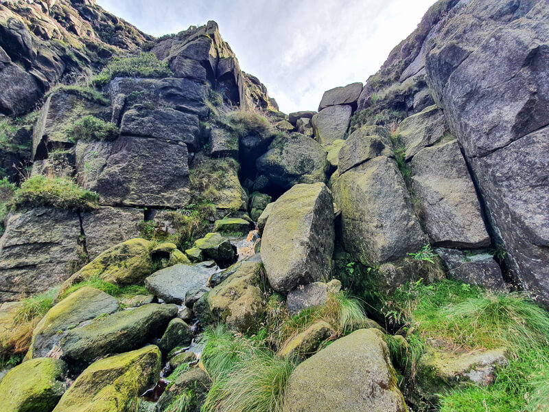
The ascent up Blackden Brook can involve a small amount of scrambling in some parts before you get to the main scramble. About 200 metres before the top, the route splits. On your left the footpath continues up to the top, on your right, there’s a rocky scramble route to the top.
Take your pick (footpath or scramble) to continue to the top, depending on the weather and yours and your group’s abilities.
Stage 2 – Blackden Brook to Fairbrook (top)
Distance: 1.9 mile/3.1 km
Grid reference SK 11647 88261
Once you reach the top of the Kinder Plateau, turn right and follow the footpath along the edge. Head north for about 500 metres initially but then the path bends round to the left and heads west for about 1.6 km. (If you did the scramble route, it’s an extra 100 metres because you ascend to a point slightly further left)

The last 1 km along the edge then bears slightly north and bends round to the left again, bringing you to the top of Fairbrook. The footpath crosses a very narrow stream at the top. From here you need to begin walking northeast gradually descending to pick up the footpath that runs alongside Fairbrook.

Stage 3 – Fairbrook to Fairbrook (bottom)
Distance: 1.6 miles/2.5 km
Grid reference SK 09339 89117
Continuing heading down the brook, towards the boundary fence, go through the gate and keep heading down. There are another two waterfalls on the way down, again both off-path.

The best way down is to descend near where the tree is growing out of the path (sideways). You can scramble down here to the first waterfall, then up and over to reach the second one (photo below).
(Both of these are tricky to get to and I wouldn’t recommend on a wet day as the grass will be really slippy you’ll probably end up in the water!)

Keep ascending the footpath with Fairbrook on your right. It’s a narrow path that winds its way down to the bottom of the route. Once the footpath flattens out at the bottom and the brook widens, walk towards the drystone wall and look for a point to cross the brook.
Stage 4 – Fairbrook to Snake Pass
Distance: 1.4 miles/2.2 km
Grid reference SK 11379 90025

After you’ve crossed the brook, go through the gap in the drystone wall. After a short distance, the path then splits, one route heading uphill and the other following the boundary.
Stay on the lower path, this is a sheep trod so fades a few times but it’s a relatively good route to get you back without having to walk on the road (the only other option). The route crosses a couple of small streams on the route back and heads up and down as you walk along.

It will then bring you out alongside a drystone wall and an area where new tree saplings have been planted. Keep to the boundary and walk down then go over a stile and continue heading down to the brook. As you descend you’ll see a farm building, head towards this but just before, turn right past the brook and the wall.
You’ll then need to cross the brook and head across bearing left to the footbridge you crossed at the start. From here it’s then back up to the gate and layby.
Any questions about this route or scramble? Ask me in the comments.
Other options for this walk
Extend the walk
Fancy a longer walk? Another longer route will be added soon. Sign up for walks below to receive straight to your inbox when it’s out!
More walks in the Peak District
Love the walks in the Dark Peaks? You might like these Peak District circular walks.
- Laddow Rocks + Black Hill via Pennine Way From Crowden | 9-Mile Route
- Mam Tor Via Jacob’s Ladder Walk From Edale | 10-Mile Route
- Higher Shelf Stones Circular Walk (+ Plane Crash Site) | 6-Mile Walk
Or check out all our Peak District walking routes here
Save me to your Hiking boards on Pinterest


*Peak District Walks participates in the Amazon Services Associates Programme, as well as other affiliate programmes. If you purchase through these, Peak District Walks earn from the qualifying links. This is at no extra cost to you. Read more here.
Peak District Walks is a FREE online resource. Are you enjoying the walks? You can say thank you and buy me a coffee here. Thank you very much 🙂
Peak District charity patches
Read about the charity here.


Charity Patches

Charity Patches

Charity Patches

Charity Patches

Charity Patches

Charity Patches
Need more help planning your Peak District trip?
Join our Peak District walks Facebook page, follow us on Instagram and Twitter for inspiration.
More information on the Peak District, including transport options, where to stay, best Peak District pubs + other useful resources.
Check out the 7 YHAs in the Peak District and find the best walks direct from your accommodation.
Find out what maps you will need for your trip here.
Top tips - Read our useful guides on hiking tips here.
Guided Walks with an introduction to map reading (see dates here).
Visit our hiking recommendations page, (footwear, clothes + kit).
Or get in touch and I will help as best I can :).
Please note 'Peak District Walks' accepts no liability for any injuries or accidents resulting from walking our routes. We always recommend you wear appropriate footwear to avoid injuries and to take a paper map and compass on your walks. Read more here.
Pingback: Featherbed Moss, Holme Moss (Black Hill) + Hey Edge Trig Walk From Crowden | 11-Mile Route - Peak District Walks
Pingback: Harry Hut + Lantern Pike Trig Walk From Hayfield | 10-Mile Route - Peak District Walks
Pingback: Crowden Clough Scramble (Via Grindslow Knoll) From Barber Booth | 6-Mile Route – Peak District Walks
Pingback: 7 Fun Peak District Scrambles + BEST Routes – Peak District Walks