
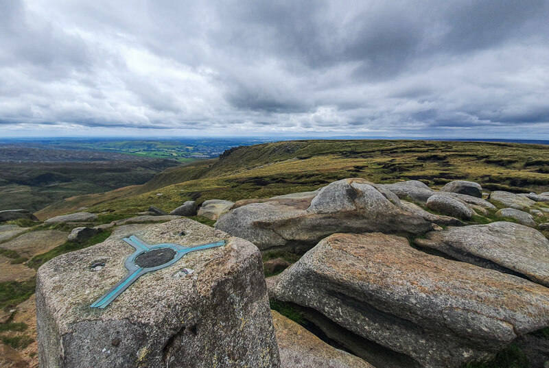
Higher Shelf Stones is the third highest point in the Peak District at 621 metres, but it’s the hill with the most-defined summit, unlike Kinder Scout and Bleaklow that are moorland plateaus.
This circular walk starts from Snake Pass next to the Pennine Way path, which means much of the ascent is done, for the first part of the walk. It takes a quieter path to the summit of Higher Shelf Stones summit, before heading off to explore the nearby Bleaklow B29 Superfortress plane crash site and memorial plaque.
The route then takes you via Lower Shelf Stones and gradually descends to Shelf Brook, a meandering stream that you follow until you start hiking uphill again. In late summer the purple heather comes to life and on a clear day you can see back up to Higher Shelf Stones summit.
Here you will find details on how to get to the start of the walk at Snake Pass, parking options, map, GPX file, route information, plus a detailed step by step guide of the walk.
I’ve also included an easier 4-mile walk if you’re looking to do a shorter walk to visit the summit and crash site.
Let me know in the comments if you’ve done this Higher Shelf Stones walk or visited the crash site?
Buy a printable/downloadable PDF route guide for the walk here.
Higher Shelf Stones from Snake Pass

Walk information
Walk type: Short moderate circular walk
Distance: 5.8 miles/9.3 km
Walk time: 3-3.5 hours
Total ascent: 488 m/1,601 ft
Highest point: 621 m/2,037 ft
Walk highlights: Views from Higher Shelf Stones, B29 Superfortress crash site + memorial plaque, Lower Shelf Stones, walking along Shelf Brook
Trigs: 1 – Higher Shelf Stones
Ethels: 1 – Higher Shelf Stones
Stiles: 0
Higher Shelf Stones walk map

© Crown copyright and database rights (2024) OS 002572460
Walk start point
Start grid reference: SK 08808 92913
Car parking location: Snake Pass (A57), Glossop.
Please note this is free lay-by car parking. It’s a small lay-by so at weekends cars will park along Snake Pass. Update January 2022 – Some sections now have double yellow lines so please check it’s safe before you park. There is no exact postcode to the location so I’ve removed for this location to avoid confusion. Click here for the Google maps pin.
Public transport
Nearest train station: Glossop train station (4 mile/6.5 km). From the train station, there are no public transport options to the start but you could pick up the route at the bottom of Doctor’s Gate path (about 2 miles) and do the circular walk starting from there (Grid reference SK 06440 94413)
In summer 2021, there was a X57 bus service, this has currently ended and I’ve not heard if it’s starting again, let me know if you find out!
Facilities on the walk
There are no public toilets or facilities anywhere on the walk.
Water on your walk – I recommend a filter water bottle for your Peak District walks, it saves you carrying extra weight and you can fill up safely and drink water from the streams on your walk.
Other useful information

As Higher Shelf Stones is the third highest point in the Peak District it can also be quite cold at the top, even on a summer’s day so take some layers and a hat for the top!
On a day with poor visibility, it’s very easy to get lost on Bleaklow, please take navigation equipment to make sure you don’t end up lost!
There are also a few muddy sections on the walk, so be prepared to get muddy in places!
Peak District weather
Check the weather for your walk location and hills
Please check the weather between Glossop and Bleaklow (the nearest summit to Higher Shelf Stones) as the temperature can vary greatly from the valley to the hilltop.
- BBC Weather for Glossop
- Met Office weather for the Peak District
- Met Office weather for Bleaklow (Derbyshire) and/or MWIS (Mountain Weather Information Service) for the Peak District.
Ordnance Survey Walk Map
The map for this walk is OL1 – Peak District (Dark Peak Area). Check offers here with Ordnance Survey or Amazon
And don’t forget your compass, I recommend the Silva Expedition or the Silva Classic compass.
For online maps, I recommend the OS Online App (I have been using it for many years and it is worth getting if you want to start walking more). Check prices here for the one-month or annual option with the OS Online App. All the walks on the website are created using OS Online + you can download them to the App.
Check prices here for the one month or yearly option with OS Online App.
Want to read later? Save the walk to Pinterest

Higher Shelf Stones walk route
Stage 1 – Snake Pass (Pennine Way) to Higher Shelf Stones
Distance: 1.6 miles/2.5 km
Grid reference SK 08805 92915

From the layby on Snake Pass, walk down the Pennine Way path for about 500 metres until you reach a wooden post. Turn left here onto a single track and walk down for about 200 metres. On your right, there is a footpath heading along the edge, which is quite hidden (if you reach the gate you’ve missed it).

Follow this single track as it runs parallel to Crooked Clough below you, with Higher Shelf Stones in the distance. Walk until you see a waterfall, then the path splits. Take the left-hand path, heading down, across the stream and back up.

From here, the path gets muddy in places so you might need to weave a bit to avoid the muddy bits! You then cross another stream and continue walking across the moorland. From here, it’s just under 1 km, heading north to the far edge of Higher Shelf Stones.
Walk up the path towards the rocks and then at the top turn right to reach the summit and the trig point at Higher Shelf Stones.
Stage 2 – Higher Shelf Stones to Shelf Brook (Doctor’s Gate)
Distance: 2 mile/3.3 km
Grid reference SK 08894 94785
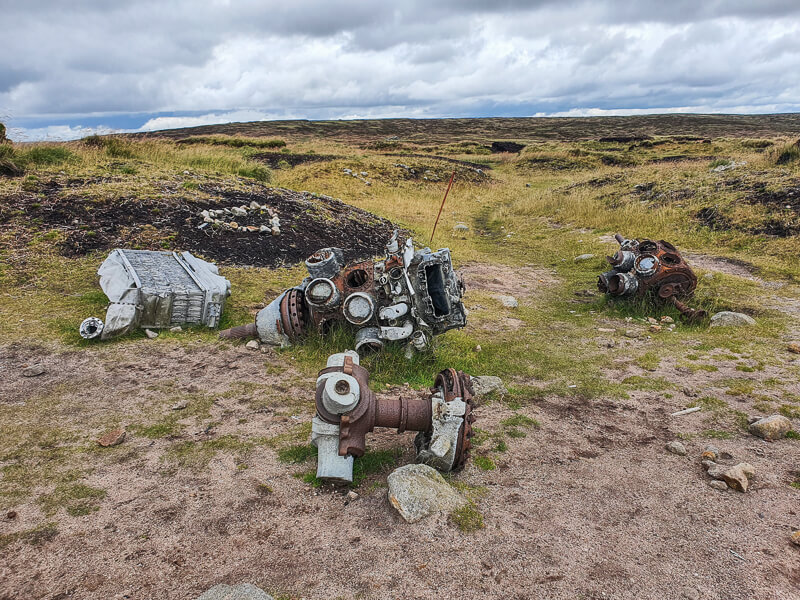
From the trig point, walk east to do a small detour to visit the B29 Superfortress crash site (grid reference SK 09063 94874). The plane crash remains are scattered over a wide area, along with a small memorial plaque with the sad story of the crash from 1948.
Then retrace your steps back to the trig point and continue your circular walk heading west to Lower Shelf Stones. From here you begin to descend gradually, keeping on the single path that winds down the moorlands then takes you up again. Keep walking west, now heading back downhill again towards a gate with a small tarn on the right of the path further down.

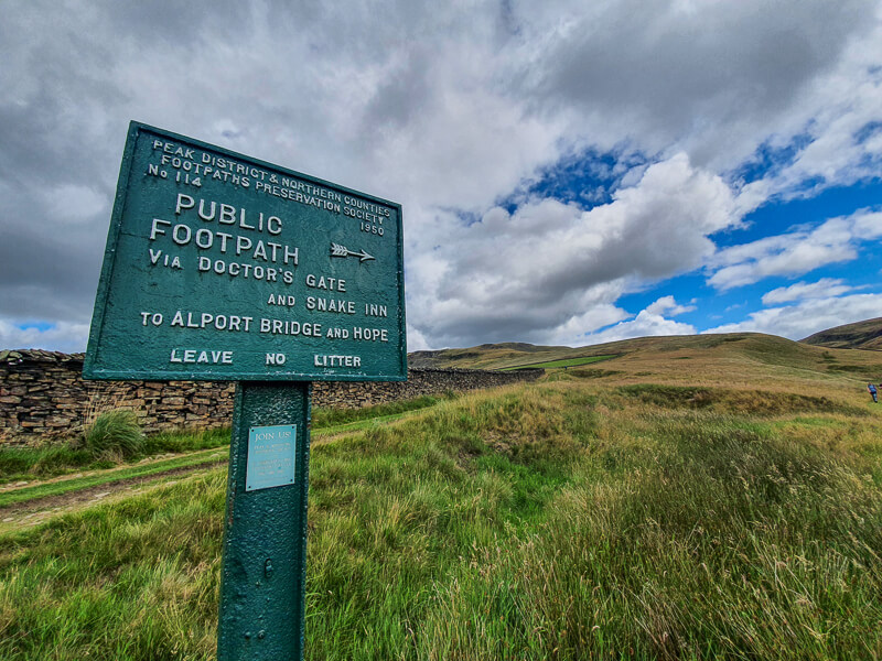
Continue walking downhill, until you reach a track after about 1 km, bear right and follow the track as it continues to descend all the way to some farm buildings. At this point, you then want to turn sharp left, almost doubling back on the path and follow the public footpath sign via Doctor’s Gate and Snake Inn.
Stage 3 – Shelf Brook to Snake Pass
Distance: 2.2 miles/3.6 km
Grid reference SK 06422 94414

The footpath follows Shelf Brook closely for about 1 km, in late summer the path looks beautiful with all the heather in flower. Walk until you reach a newly replaced wooden bridge, cross the brook here and keep on the narrow path and through a metal gate.
In some places, the path can be very muddy, even in the summer months, so you might need to weave in and out to avoid getting totally muddy. Or of course, if you’re wearing hiking boots, plod straight through!

The Doctor’s Gate path from the bridge is about 1.5 km, it’s a steady hike uphill then just before the top it does a small switchback before reaching a wooden gate, then another few metres and you’re back where you followed the path to Higher Shelf Stones.
Walk until you reach the Pennine Way path, turn right and you’re back at Snake Pass.
Buy a printable/downloadable PDF route guide for the walk here.
Have you visited the Higher Shelf Stones summit and crash site, what did you think? Let me know in the comments.
Other options for this walk
Shorten the walk
Want to visit Higher Shelf Stones but with a shorter (and easier) walk? Instead of continuing the walk across to Lower Shelf Stones you can navigate back to the Pennine Way path, this can be tricky to navigate so make sure you take a map and compass.
It’s about 800 metres from the crash site to the Pennine Way but it’s easy to get lost especially in bad weather. But once you reach the wide, well-trodden Pennine Way path you simply turn right and follow it back to Snake Pass.
This option is about 3.7 miles/6 km but it’s only 158 metres of ascent as Snake Pass is already pretty high up! View the walk map here.
Walk mapMore walks in the Peak District
Looking for more short walks in the Dark Peaks? Check out these routes
Or check out all our Peak District walking routes here
Save me to your Hiking boards on Pinterest


*Peak District Walks participates in the Amazon Services Associates Programme, as well as other affiliate programmes. If you purchase through these, Peak District Walks earn from the qualifying links. This is at no extra cost to you. Read more here.
Peak District Walks is a FREE online resource. Are you enjoying the walks? You can say thank you and buy me a coffee here. Thank you very much 🙂
Peak District charity patches
Read about the charity here.


Charity Patches

Charity Patches

Charity Patches

Charity Patches

Charity Patches

Charity Patches
Need more help planning your Peak District trip?
Join our Peak District walks Facebook page, follow us on Instagram and Twitter for inspiration.
More information on the Peak District, including transport options, where to stay, best Peak District pubs + other useful resources.
Check out the 7 YHAs in the Peak District and find the best walks direct from your accommodation.
Find out what maps you will need for your trip here.
Top tips - Read our useful guides on hiking tips here.
Guided Walks with an introduction to map reading (see dates here).
Visit our hiking recommendations page, (footwear, clothes + kit).
Or get in touch and I will help as best I can :).
Please note 'Peak District Walks' accepts no liability for any injuries or accidents resulting from walking our routes. We always recommend you wear appropriate footwear to avoid injuries and to take a paper map and compass on your walks. Read more here.
Pingback: Snake Woodlands, Higher Shelf Stones Long Walk | 14-Mile Route - Peak District Walks
Pingback: Higher Shelf Stones Short Walk (+ Bleaklow Plane Crash Site) | 4-Mile Route - Peak District Walks
Pingback: Alderman's Hill Walk (+ Saddleworth Trig) From Greenfield | 3 or 5 Mile Route - Peak District Walks
Pingback: Top 10 Highest Peak District Hills + Mountains - Peak District Walks