
Fancy hiking to all the top 10 highest Peak District hills + mountains? Well, here’s the list for you to tick off on your walks.
Will you hike them in height order, maybe one at a time, or try and complete them on a couple of huge hikes? Most of the hills are located in the Dark Peak Area of the Peak District, with a couple in the White Peak Area in Cheshire.
Here we will share the highest hills and also include routes you can do to tick them off.
Let me know in the comments if you’re planning this challenge or if you’ve already done it!
Top 10 Highest Peak District Hills + Mountains

These top 10 highest hills in the Peak District are listed in height order, starting with Kinder Scout, well known for being the highest spot in Derbyshire and the Peak District.
We’ve also included walks that detail the routes, walk map and GPX.
All the 10 highest Peak District hills are included on the Peak District Ethel’s list – so that’s 10 to tick off on that challenge. And 6 out of the 10 hills also have trig points, so if you’re completing that challenge you can tick those ones off.
Check out the list of 88 trig points here and 95 Peak District Ethels here.
Kinder Scout 636 m
(Highest point in the Peak District + Derbyshire)

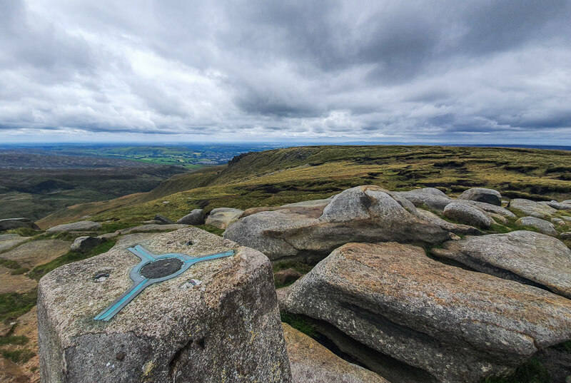
The official highest point in the Peak District isn’t (as you might have thought!) the trig point at Kinder Low. In fact, the true summit is approximately 400 metres across the Kinder Plateau.
Many of our walks detour past Kinder Low but don’t go directly to the summit. Why you might ask? Well, the true summit is slightly less interesting than the impressive Kinder Low trig point which makes for a better photo.
View our Kinder Scout walks here:
Edale walks to Kinder Scout
- Kinder Scout Walks (via Jacob’s Ladder) From Edale | 8, 9 + 10-Mile Routes
- Kinder Scout Walk From Edale (via Grindsbrook Clough) | 8-Mile Route
- Edale to Kinder Downfall Circular Walk (+ Kinder Reservoir) | 15-Mile Route
Hayfield walks to Kinder Scout
- Kinder Scout Walk From Hayfield (Via Kinder Downfall) | 9 Mile Route
- Kinder Scout Walk From Hayfield (Via Red Brook Scramble) | 9-Mile Route
Bleaklow 633 m

The second highest mountain in the Peak District is Bleaklow, located in the middle of the plateau. You might feel a tad disappointed at the views, but it’s still an impressive feat and worth climbing the pile of stones to be at the highest point!
View our Bleaklow walks here:
Higher Shelf Stones 622 m
Higher Shelf Stones is the third highest point in the Peak District and the final English Nuttall in the National Park. (Nuttalls are all hills over 2000 ft with a 50 m prominence – there are 254 in England).
In addition, the Highest Shelf Stones summit is very close to the B-29 Plane crash site, which is a good place to visit when you’re ticking off this mountain.
View our Higher Shelf Stones walks here:
- Higher Shelf Stones Short Walk (+ Bleaklow Plane Crash Site) | 4-Mile Route
- Higher Shelf Stones Circular Walk (+ Plane Crash Site) | 6-Mile Walk
- Snake Woodlands, Higher Shelf Stones Long Walk | 14-Mile Route
Grindslow Knoll 601 m

This is the final hill in the Peak District that’s over 600m and can often get missed out as it’s a slight detour from the Kinder Plateau. There are beautiful views all around the large cairn at the top.
View our Grindslow Knoll walks here:
- Grindslow Knoll (via Grindsbrook Clough) Short Walk from Edale | 4-Mile Route
- Grindslow Knoll Walk (via Ringing Roger) From Edale | 5.5-Mile Route
- Crowden Clough Scramble (Via Grindslow Knoll) From Barber Booth | 6-Mile Route
Black Hill 582 m
(Highest point in West Yorkshire)

Black Hill is located on the Pennine Way trail, about 4 miles from Crowden. This hill also includes a trig point, although it’s named Holme Moss trig point so sometimes is overlooked on the trig bagging list!
View our Black Hill walks here:
- Featherbed Moss, Holme Moss (Black Hill) + Hey Edge Trig Walk From Crowden | 11-Mile Route
- Laddow Rocks + Black Hill via Pennine Way From Crowden | 9-Mile Route
Brown Knoll 569 m
Another one with a trig point to mark the top. Brown Knoll is a large plateau with a flagstoned path leading its way over the summit. It’s a hike I’ve done many times, especially on the Edale Skyline; however, I only seem to have group photos and not an actual one of the top!
View our Brown Knoll walks here:
- Edale Skyline Route | 20-Mile Route (Ultimate Peak District Challenge)
- Mam Tor Via Jacob’s Ladder Walk From Edale | 10-Mile Route
Shining Tor 559 m
(Highest point in Cheshire)

Another hill with a trig point to mark the summit and on a clear day you have beautiful views across to the iconic hill Shutlingsloe, at 506 m it doesn’t quite make the top 20 highest hills in the Peak District but it’s still another hike worth doing.
View our Shining Tor walks here:
- Errwood Hall + Shining Tor Walk From Errwood Reservoir | 5-Mile Route
- Shining Tor Circular Walk via Goyt Valley From Derbyshire Bridge | 10-Mile Route
Axe Edge Moor 551 m

Axe Edge Moor is a lovely hill nestled between some lovely Peak District hills with views of Shining Tor, Shutlingsloe, and Chrome Hill.
View our Axe Edge walk here:
Axe Edge Moor Trig + Cheeks Hill Walk From Derbyshire Bridge | 6-Mile Route
Lord’s Seat (Rushup Edge) 550 m

Lord’s Seat on Rushup Edge gives you beautiful views of Mam Tor, with fewer people so it’s a great hill to visit if you want to enjoy views on a quieter walk.
View our Lord’s Seat walks here:
- Rushup Edge Short Walk From Barber Booth | 5-Mile Route
- Rushup Edge + Mam Tor Walk | 6-Mile Route
- Edale Skyline Route | 20-Mile Route (Ultimate Peak District Challenge)
High Stones (Howden Edge) 550 m
(Highest point in South Yorkshire)
This hill is located not far from Margery Hill,and our walk below doesn’t include this summit. If you walk a further 1.5 km from the trig you’ll bag this hill on your walk.
View our walks here:
Do you have any more questions about these highest hills and mountains? Ask me in the comments below.
Other information
Ordnance Survey Walk Maps
For these walks, there are two maps that cover them OL1 – Peak District (Dark Peak Area) and OL24 – Peak District (White Peak Area)
Shop online at Ordnance Survey
And don’t forget your compass, I recommend the Silva Expedition or the Silva Classic compass.
For online maps, I recommend OS Online App (I have been using it for many years and it is worth getting if you want to start walking more). Check prices here for the one-month or annual option with OS Online App. All the walks on the website are created using OS Maps Online + you can download them to the OS Maps App.
Check prices here for the one month or yearly option with OS Online App.
More walks in the Peak District
Love hillwalking in the Peak District? You might like these Peak District circular walks that are in the top 20 highest hills list!
- 10 Mam Tor Walks in the Peak District (Short, Medium + Long Walking Routes)
- Derwent Edge Circular Walk (via Lost Lad + Back Tor) | 8-Mile Route
- Arnfield Moor, Chew Reservoir + Featherbed Moss Trig Walk From Crowden | 12-Mile Route
Or check out all our Peak District walking routes here
*Peak District Walks participates in the Amazon Services Associates Programme, as well as other affiliate programmes. If you purchase through these, Peak District Walks earn from the qualifying links. This is at no extra cost to you. Read more here.
Peak District Walks is a FREE online resource. Are you enjoying the walks? You can say thank you and buy me a coffee here. Thank you very much 🙂
Peak District charity patches
Read about the charity here.


Charity Patches

Charity Patches

Charity Patches

Charity Patches

Charity Patches

Charity Patches
Need more help planning your Peak District trip?
Join our Peak District walks Facebook page, follow us on Instagram and Twitter for inspiration.
More information on the Peak District, including transport options, where to stay, best Peak District pubs + other useful resources.
Check out the 7 YHAs in the Peak District and find the best walks direct from your accommodation.
Find out what maps you will need for your trip here.
Top tips - Read our useful guides on hiking tips here.
Guided Walks with an introduction to map reading (see dates here).
Visit our hiking recommendations page, (footwear, clothes + kit).
Or get in touch and I will help as best I can :).
Please note 'Peak District Walks' accepts no liability for any injuries or accidents resulting from walking our routes. We always recommend you wear appropriate footwear to avoid injuries and to take a paper map and compass on your walks. Read more here.