
Axe Edge Moor is a beautiful part of the Peak District and sets the location for this walk – including Axe Edge Moor trig point and Cheeks Hill which is the county top of Staffordshire at 520 metres.
A fantastic walk that ticks off a trig and two Ethels, it’s perfect if you’re taking on one of the awesome Peak District Challenges this year. We will also give you the option to add on Burbage Edge trig point which is a 3 km out and back, also on the Ethels list too!
The walk begins from Derbyshire Bridge car park and heads gradually uphill, you have the choice early on whether to add Burbage Edge trig point. If not, then you head towards Axe Edge Moor and onwards to Axe Edge trig point, with beautiful views of Shining Tor in the northwest and Chrome Hill in the southeast.
You’ll walk along Axe Edge to Axe Edge End, the loop back via Cheeks Hill before returning back to Derbyshire Bridge car park.
Important – you will see signs saying that dogs are not allowed on a large section of the moorland. However, the sign goes on to say it doesn’t apply to ‘registered assistance dogs and dogs kept under effective control on Public Rights of Way’. Our interpretation of this is that dogs are allowed on the marked footpaths/bridlepaths on the moorlands but they must be kept under control i.e. on leads.
Here you will find details on how to get to the start of the walk, route information, map, GPX file, plus a detailed step by step guide of the walk.
Let me know in the comments if you’ve done this walk and what you think!
Buy a printable/downloadable PDF route guide for the walk here.
Printable PDF GuideAxe Edge Moor + Cheeks Hill from Derbyshire Bridge

Walk information
Walk type: Medium Circular Walk
Distance: 5.8 miles/9.4 km
Walk time: 2.5-3.5 hours
Total ascent: 238 m/780 ft
Highest point: 550 m/1,804 ft
Walk highlights: Beautiful views from Axe Edge Moor, Axe Edge trig and reaching the highest point in Staffordshire – Cheeks Hill, crossing the start of the River Dane.
Trigs: 1 – Axe Edge (Option to add Burbage Edge)
Ethels: 2 – Axe Edge + Cheeks Hill (Option to add Burbage Edge)
Stiles: 3 (wooden stiles)
Axe Edge Moor + Cheeks Hill walk map + GPX
gpx file

© Crown copyright and database rights (2024) OS 002572460
Click for online map
Walk Start Point
Start grid reference: SK 01808 71575
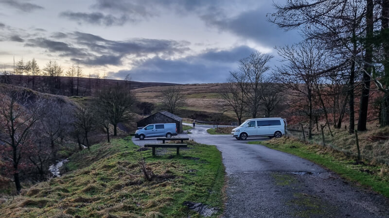
Car parking address: Derbyshire Bridge car park, off Buxton Road, Macclesfield, SK11 0AR – Google location
This is a medium sized free car park off the A 537 main road, there’s no exact postcode for the car park but I’ve detailed the one at the Cat and Fiddle pub just up the road.
Public transport
There are no public transport options for this start point.
Facilities on the walk
There are public toilets available at the start of the walk at Derbyshire Bridge car park, the sign on the door states these are open 9-5 pm.
On the remainder of the route there are no other facilities. The nearest pub is the Cat and Fiddle which is on the main road and a short drive up from the car park once you’ve finished your walk.
Other useful information
I walked the route in winter and some sections were very muddy and boggy in places, waterproof boots and gaiters are recommended. Or alternatively, save this route for summer when it’s less damp!
Please note that there is a sign stating dogs are not allowed on the Open Access land to protect Moorland birds (image below of the area it covers which is a large part of our walk). Sorry this isn’t a dog friendly route.

There are also a couple of very busy roads to cross on this route, so please take care.
Please keep the Peak District beautiful and respect everyone who uses the park. Take ALL your rubbish home to dispose of and remember close gates (as you found them). Thank you so much.
Would you know what to do in an emergency situation?

We have a guide with what to do, who you need to call and also some useful kit that should be in your backpack. Ask us any questions in the comments or via our social media.
Happy hiking + stay safe
read herePeak District weather
Check the weather for your walk location and hills. We’d recommend that you check a few resources and for hilly walks look at the weather conditions in the valley and on the hilltop as they can greatly vary.
- BBC Weather for Macclesfield
- Met Office weather for Shining Tor (nearest hill on Met Office)
- Met Office weather and/or MWIS (Mountain weather information service) for the Peak District
Ordnance Survey walk map
The map required for this walk is the Ordnance Survey OL24 – Peak District (White Peak Area). Check prices here with Ordnance Survey or Amazon. If you’re hiking in all weathers the Active OS maps are good to have as they are laminated so better on rainy days.
View both Peak District map options here.
And don’t forget your compass, I recommend the Silva Expedition or the Silva Classic compass.
For online maps, I recommend OS Online App (I have been using this for 4+ years and worth getting if you want to start walking more). Check prices here for the one month or yearly option with OS Online App. All the walks on the website are created using OS Maps Online and you can easily download them to the App to use alongside a map and compass.
See both maps that cover the Peak District here.
Want to learn more map skills? Check out our Guided Walks with map reading skills here.
Axe Edge Moor + Cheeks Hill walk route
Stage 1 – Derbyshire Bridge car park to Axe Edge Moor
Distance: 1.2 miles/2 km
Grid reference SK 01808 71575
Begin by taking the wide track running uphill, parallel with the car park that heads east. Follow this gradually uphill and admire stunning views of the Goyt Valley with Shining Tor in the northwest. After about 1 km, (approx 20-30 mins) you’ll reach the top of the incline.
Optional – Turn left to add Burbage Edge trig here. See instructions in Extend walk section.

Or alternatively, continue straight on for about 50 metres and turn right where there’s a wooden fence/stile (photo above), signposted Axe Edge Moor. Follow this grassy path until it reaches a fork, take the left-hand path over the first wooden stile and continue towards the road.

Stage 2 – Axe Edge Moor to Axe Edge Trig
Distance: 0.9 mile/1.4 km
Grid reference SK 0289 7133
Cross the road safely, then head over the next wooden stile (photo above). Please note this is where dogs are not allowed, as per information in the introduction and ‘Other Information’ section. Follow the wide path until you reach another fork, take the left-hand path and continue. As you walk along the next section, on a clear day, on your left you’ll see a hill with the trig on (Axe Edge), or if it’s cloudy there’s a square wooden fence.

Take the path on the left (photo above) that heads east alongside the fence (shown as a rectangle on the map). The path heads down then up to a smaller hill before continuing down then up again to Axe Edge hill and the trig point, marked with stones around the summit.

Stage 3 – Axe Edge Moor Trig to Cheeks Hill
Distance: 2.2 miles/3.6 km
Grid reference SK 0350 7062
From Axe Edge Moor trig, turn right, heading south along the ridge. After about 1 km, you’ll reach a gate onto the road. Again, safely cross the road and take the path heading downhill which crosses the small stream known as Cistern’s Clough. The path heads left back uphill on to Axe Edge where you follow it along the ridge.
Towards your left, you’ll have great views of Chrome Hill and you might see the smaller Parkhouse Hill if you’re lucky!

After 1.5 km, you’ll descend towards a track alongside a house (photo above). Turn right and walk along the track, ahead you should now see another iconic hill Shutlingsloe. Turn right again at the junction and continue on the track, looking for a faint path on the right (photo below) heading across the moorlands. There’s a wide metal gate but if you reach this you’ve missed the turning (only by 20 metres!)

Head uphill on the moorland path and you’ll reach a few large stones on the hilltop. Keep on the path, as it joins another turn right. Cheeks Hill is now the small hill on your left (slightly lower than where the stones were). Turn left and walk a short distance off-path to the top then keep going to pick up the path on the other side.

The official Cheeks Hill summit is at the corner of the fences, this is the highest point of Staffordshire. And means you walk in two counties on this route!
Stage 4 – Cheeks Hill to Derbyshire Bridge
Distance: 1.5 miles/2.4 km
Grid reference SK 0261 6990
From Cheeks Hill, turn right to pick up the path, now heading downhill in a northerly direction. You’ll cross over the start of the River Dane, don’t worry it’s the start of the river so it’s a narrow crossing!

Keep walking until you reach the road, turn left and walk to the main road A537, cross over and turn left, then right again down the small road and cross the A537 again.

Now keep walking straight ahead down the road, as the road bends to the left you turn right picking up a footpath. After a short distance go through the gate on the left (photo above) and follow this path all the way back to Derbyshire Bridge car park.
Ask me questions about this Axe Edge Moor walk in the comments below.
Buy a printable/downloadable PDF route guide for the walk here.
Printable PDF GuideMore walk information
Extend the walk

If you’d like to add in Burbage Edge trig point you can find the route instructions, OS Map and GPX file here.
After hiking the first 1.2 km along the track instead of turning right towards Axe Edge Moor you go through the gate on your left towards Burbage Edge trig point. It’s a simple out and back route following the path, bearing right, then right again up to the wall and simply follow this all the way up to the trig point. And then return the same way to pick up the walk.
This adds 3 km/2 miles onto the walk, but only about 50 metres ascent, so you’ll need to allow roughly an extra 45-60 minutes.
Click here for the OS map and here for the GPX.
More walks in the Peak District
Love the walks in the Peak District? You might like these trig and Ethel walks.
- Harry Hut + Lantern Pike Trig Walk From Hayfield | 10-Mile Route
- Alderman’s Hill Walk (+ Saddleworth Trig) From Greenfield | 3 or 5 Mile Route
- Rushup Edge + Mam Tor Walk | 6-Mile Route
Or search all our Peak District walks here
Peak District Walks is a FREE online resource. Are you enjoying the walks? You can say thank you and buy me a coffee here. Thank you very much 🙂
Peak District charity patches
Read about the charity here.


Charity Patches

Charity Patches

Charity Patches

Charity Patches

Charity Patches

Charity Patches
Need more help planning your Peak District trip?
Join our Peak District walks Facebook page, follow us on Instagram and Twitter for inspiration.
More information on the Peak District, including transport options, where to stay, best Peak District pubs + other useful resources.
Check out the 7 YHAs in the Peak District and find the best walks direct from your accommodation.
Find out what maps you will need for your trip here.
Top tips - Read our useful guides on hiking tips here.
Guided Walks with an introduction to map reading (see dates here).
Visit our hiking recommendations page, (footwear, clothes + kit).
Or get in touch and I will help as best I can :).
Please note 'Peak District Walks' accepts no liability for any injuries or accidents resulting from walking our routes. We always recommend you wear appropriate footwear to avoid injuries and to take a paper map and compass on your walks. Read more here.
*Peak District Walks participates in the Amazon Services Associates Programme, as well as other affiliate programmes. If you purchase through these, Peak District Walks earn from the qualifying links. This is at no extra cost to you. Read more here.
Would love some clarification please! The no dogs sign says that it doesn’t apply to ‘dogs kept under effective control on Public Rights of Way’. Does this not mean dogs can be walked on lead along the footpaths? Thanks!
Hi Gemma, yes, that’s correct, however because the route I’ve plotted goes off the public rights of way (the green dashed lines) that means that the route I’ve planned isn’t suitable for dogs. If you plan to do a walk that goes via the public rights of way then you’d be fine to walk your dog on a short lead there 🙂
Very enjoyable walk. My only comment would be that if you come in winter be aware that both roads which head down to the carpark from the main road are steep, single file and not gritted. It had snowed the days before I came and the main road was completely clear but the side roads still had a few cm of snow on them. I parked in the lay-by opposite the pub which adds another 20 minutes each way.
Ah thanks, yes, there are many side roads that can cause problems when it snow. I guess, if in doubt then don’t go but I really appreciate your feedback, it’ll be useful for many people visiting 🙂