
This walk from Birchover is a lovely route with plenty to see on the way. Starting with a mini exploration around the hidden gem Rowtor Rocks then onwards to Stanton Moor where you’ll come across The Tower, Nine Ladies, Cork Stone and a bonus trig point too.
From Birchover car park, first head towards the Druid Inn pub then it’s on to Rowtor Rocks. Read our section in ‘Other information’ to find out more about these rocks. Once you’ve explored this area you continue looping around with views in the distance of Robin Hood’s Stride and Cratcliffe Crags.
Next you’ll walk along countryside paths until you reach Stanton Moor, there’s loads to explore in here, including the Nine Ladies Stone Circle and the trig point on Stanton Moor, known as Moor Plantations, for those trig baggers to tick off on the trig list!
More trig walks for beginners here.
Here you will find details on how to get to the start of the walk at Birchover, route information, map, GPX file, plus a detailed step by step guide of the walk.
Buy a printable/downloadable PDF route guide for the walk here.
Fancy a longer route? – Try our 10-mile walk from Birchover
Let me know in the comments if you’ve done this walk and what you think!
Rowtor Rocks + Stanton Moor Trig from Birchover

Walk information + GPX
Walk type: Short circular walk
Distance: 4.5 miles/7.2 km
Walk time: 2-3 hours
Total ascent: 182 m/600 ft
Highest point: 323 m/1,061 ft
Walk highlights: Exploring Rowtor Rocks, views across to Robin Hood’s Stride, Stanton Moor, Nine Ladies Circle and the Cork Stone
Trigs: 1 – Moor Plantations (Stanton Moor)
Ethels: 1 – Stanton Moor
Stiles: 1 + 2 optional (all wooden stile with dog friendly option)
Rowtor Rocks + Stanton Moor walk map

© Crown copyright and database rights (2024) OS 002572460
Click for online mapWalk start point

Start grid reference: SK 24104 62442
Car parking address: Birchover Stone car park, Birchover Road, DE4 2BN – Google location
Birchover Stone is a small free car park with approximately 20 spaces off the main road. There is additional parking on the road further uphill, please ensure you don’t block the road for emergency vehicles.
Public transport – The local Number 172 bus runs through Birchover which can be caught from various stops along the A6 or via a train link at Matlock.
Facilities on the walk
There are no public toilets available at the start of the walk at Birchover car park; however close to the centre of Birchover village there are public toilets which you can do a mini detour from the route to stop at.
There are two pubs in Birchover, The Druid Inn which you walk past on the route, and a short distance away the Red Lion Inn.
Water on your walk – I recommend a filter water bottle for your Peak District walks, it saves you from carrying extra weight and you can fill up safely and drink water from the streams on your walk.

Other useful information
This walk takes you via Rowtor Rocks in Birchover, please note there is no public right access here (shown by the shaded green wooded area on the map, lime green shaded sections are the public access areas). However, there are signs saying that those visitors who wish to explore and be respectful to the residents, wildlife and environment are welcome (see below).
In addition, there are several cliffs with steep drops so please take care when exploring. The access is at the discretion of the landowner, The Thornhill Settlement and if not respected it may be revoked at any time.
The Cork Stone has stone foot holds and metal hand holds so it it possible to climb to the top. However, the lower foot ones are very well-worn. Please remember it’s always easier to get up than it is to get down, and it is pretty high once you reach the top.

Please keep the Peak District beautiful and respect everyone who uses the park. Take ALL your rubbish home to dispose of and remember close gates (as you found them). Thank you so much.
Would you know what to do in an emergency situation?

We have a guide with what to do, who you need to call and also some useful kit that should be in your backpack. Ask us any questions in the comments or via our social media.
Happy hiking + stay safe
read herePeak District weather
Check the weather for your walk location and hills. We’d recommend that you check a few resources and for hill walks look at the weather conditions in the valley and on the hilltop as they can greatly vary.
- BBC Weather for Matlock
- Met Office weather for Matlock
- Met Office weather and/or MWIS (Mountain weather information service) for the Peak District
Ordnance Survey walk map
The map required for this walk is the Ordnance Survey OL24 – Peak District (White Peak Area). Check prices here with Ordnance Survey or Amazon. If you’re hiking in all weather the Active OS maps are good to have as they are laminated so better on rainy days.
View both Peak District map options here.
And don’t forget your compass, I recommend the Silva Expedition or the Silva Classic compass.
For online maps, I recommend OS Online App (I have been using it for many years and it is worth getting if you want to start walking more). Check prices here for the one-month or annual option with OS Online App. All the walks on the website are created using OS Online + you can download them to the App.
See both maps that cover the Peak District here.
Want to learn more map skills? Check out our Guided Walks with map reading skills here.
Rowtor Rocks + Stanton Moor trig walk route
Stage 1 – Birchover to Rowtor Rocks
Distance: 0.4 miles/0.7 km
Grid reference SK 2410 6244
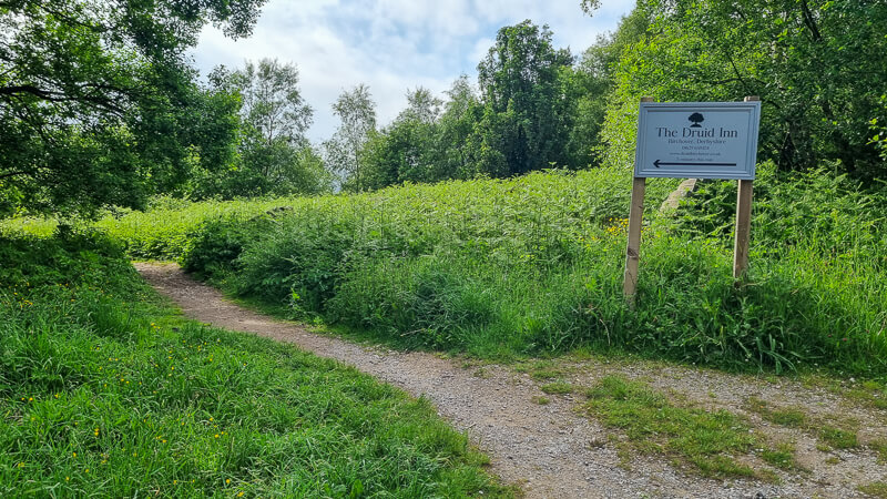
From Birchover Stone car park take the path opposite the entrance to the car park, signposted to The Druid Inn (photo above), follow this route through the woodlands. There’s a yellow signpost which points left (you can walk down here to the public toilets) or continue straight. Then towards the end the path splits, keep to the left-hand fork which brings you out at the road opposite The Druid Inn.
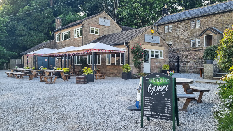
Cross the road, please take care as this is a blind corner, bear left, walking past the pub then immediately turn right down the road that runs next to the pub. Follow the footpath down here, at two points down this path you’ll see signposts for Rowtor Rocks on your right.
Rowtor Rocks – please read the section in ‘Other information’ before exploring.
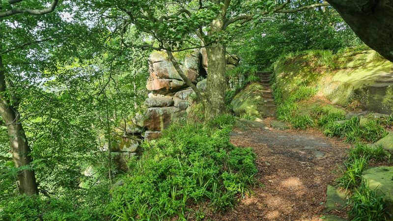
If you choose to explore Rowtor Rocks there are numerous paths and trails between the rocks so take your time and find your own paths. Once you’ve walked around the rocks head back down to the track you walked up from.
Stage 2 – Rowtor Rocks to Stanton Moor
Distance: 1.9 mile/3 km
Grid reference SK 2359 6218
Once you’re back on the footpath from Rowtor Rocks, follow the path next to the stone wall which brings you out overlooking the open countryside. The path bends around to the left, keep walking and you’ll go through a wide gate next to a stone stile (the gate was unlocked so you’re able to walk through).
In the distance on your right you’ll be able to see the iconic rocks of Robin Hood’s Stride.

At the next set of gates, walk past them on the track on the left (photo above), then immediately follow the narrow footpath on the left heading uphill. You’ll go through a stone gap in the wall and follow the path along, at the wooden post with yellow arrows keep going straight ahead. You’ll go through a a series of three wooden gates before it brings you out onto a quiet road.

On the other side of the road on your right there’s another footpath sign (photo above), go through here which will take you directly through Uppertown Farm, keep on the track, you’ll go past another house then continue straight ahead.

After 300 m there’s a crossroads of paths, turn left here through a narrow gap in-between two stones (photo above). Continue along the track, within the boundary wall and trees on your left. At the green metal gate go through the gate to the left of it and you’ll come out at Barn Farm where there’s a campsite.
Turn right following the public footpath sign then follow the signposts alongside the fence until you reach a road. Cross over then pick up the footpath and over the wooden stile into Stanton Moor (photo below).

Stage 3 – Stanton Moor to Moor Plantations trig
Distance: 1.7 miles/2.7 km
Grid reference SK 2452 6262
Once over the stile, you’ll see an information board about Stanton Moor giving a brief history of the area. Walk up the path, it then splits, take the right-hand fork along the outskirts of the moor. As you walk round there’s a wooden stile (photo below) leading to Stanton Moor Edge which is a beautiful viewpoint, a short out and back detour if you wish to add it on.

Back on the footpath continue following this around Stanton Moor until you reach the Tower, again you can climb over the stile to explore around the base of the Tower. Back on the path you’ll head through the woodlands until it brings you out the Nine Ladies stone circle and the King’s Stone.

Again there’s another information board detailing the history of the Nine Ladies with the ceremonies and rituals that took place here. Head north of the grassy path past the stone circle and smaller King’s Stone, then bear left now circling back round on the other side of Stanton Moor.
Follow the footpath all the way until it brings you back out on open moorland, take the path bearing left towards the trig point (photo below), known as Moor Plantations.

Stage 4 – Moor Plantations trig to Birchover
Distance: 0.5 miles/0.8 km
Grid reference SK2449 6291
Once you’ve stopped for the optional trig photo, continue down the path where you’ll reach a huge gritstone rock known as the Cork Stone. Tt is possible to climb up here, however you’ll need good upper body strength as the lower footholds are very worn away.

Again, once you’ve finished exploring, turn right and walk down the footpath which brings you out at a gate and shortly after you’re on the road.
Turn left walking down the road and the car park will be on your left after about 350 m.
Buy a printable/downloadable PDF route guide for the walk here.
Ask me any questions about this walk in the comments below.
Other walk information
More walks in the Peak District
Love the walks in the White Peak area of the Peak District? You might like these circular walks.
- Robin Hood’s Stride Walk + Bradford Dale From Elton | 8-Mile Route
- Chatsworth Hunting Tower Walk From Baslow | 4-Mile Route
- Blore Pastures, Ilam Hall + Park From Blore Pastures | 4-Mile Route
Or check out all our Peak District walking routes here
Peak District Walks is a FREE online resource. Are you enjoying the walks? You can say thank you and buy me a coffee here. Thank you very much 🙂
Peak District charity patches
Read about the charity here.


Charity Patches

Charity Patches

Charity Patches

Charity Patches

Charity Patches

Charity Patches
Need more help planning your Peak District trip?
Join our Peak District walks Facebook page, follow us on Instagram and Twitter for inspiration.
More information on the Peak District, including transport options, where to stay, best Peak District pubs + other useful resources.
Check out the 7 YHAs in the Peak District and find the best walks direct from your accommodation.
Find out what maps you will need for your trip here.
Top tips - Read our useful guides on hiking tips here.
Guided Walks with an introduction to map reading (see dates here).
Visit our hiking recommendations page, (footwear, clothes + kit).
Or get in touch and I will help as best I can :).
Please note 'Peak District Walks' accepts no liability for any injuries or accidents resulting from walking our routes. We always recommend you wear appropriate footwear to avoid injuries and to take a paper map and compass on your walks. Read more here.
*Peak District Walks participates in the Amazon Services Associates Programme, as well as other affiliate programmes. If you purchase through these, Peak District Walks earn from the qualifying links. This is at no extra cost to you. Read more here.