
Want to explore more of the Derbyshire Dales? This walk takes in some of the popular dales in the Wye Valley – Tideswell Dale and Miller’s Dale, as well as Water-cum-Jolly Dale and a small section of the Monsal Trail (mostly above it!)
From Tideswell car park, you begin the walk at low-level through beautiful Tideswell Dale into Miller’s Dale, following the winding River Wye and limestone cliffs surrounding the dales. After a gentle start to the walk, you then hike up to the Monsal Trail where you join for a short section before then exploring the paths above the trail.
Since you’re walking above the Monsal Trail you also have wonderful views of Miller’s Dale and the River Wye below, eventually, you pick up the busy Monsal Trail for a short distance before descending back down to the River Wye and completing the walk back via Tideswell Dale.
Here you will find details on how to get to the start of the walk at Tideswell Dale, parking options, map, route information, GPX file, plus a detailed step by step guide of the walk.
Let me know in the comments if you’ve done this walk and what you think!
Buy a printable/downloadable PDF route guide for the walk here.
Tideswell Dale, Millers Dale + Monsal Trail from Tideswell

Walk information + GPX
Walk type: Medium circular walk
Distance: 6.6 miles/10.6 km
Walk time: 3-3.5 hours
Total ascent: 481 m/1,578 ft
Highest point: 257 m/843 ft
Walk highlights: Tideswell Dale, River Wye, Millers Dale, views above Monsal Trail and Millers Dale
Trigs: 0
Ethels: 0
Stiles: 1 (option to avoid)
Tidewell Dale + Millers Dale walk map

© Crown copyright and database rights (2024) OS 002572460
Click for online mapWalk start point

Start grid reference: SK 15402 74149
Car parking address: Tideswell Dale Car Park, Tideswell, Buxton, SK17 8QH. Google Map.
This car park has about 60 spaces, the charges apply between 9 am and 6 pm.
Parking cost (cash only, no change given)
Up to 1 hour £1.50
1-2 hours £2.50
2-4 hours £4.00
All day £4.75
There is another car park on the route, just before you cross the bridge up to the Monsal Trail (SK 17671 72182) but this only has a few spaces.
Public transport
Nearest train station: Buxton train station (8 mile/13 km). From the train station, it’s about 17 minutes on a no 65 bus that drops you close to the car park (Stagecoach buses)
Facilities on the walk

There are public toilets available at the start of the walk at Tideswell Dale Car Park but no shops or other facilities.
Water on your walk – I recommend a filter water bottle for your Peak District walks, it saves you from carrying extra weight and you can fill up safely and drink water from the streams on your walk.
Other useful information
Stiles – there is one wooden stile on this walk, in stage 3 route instructions. To avoid the stile, continue walking along the Monsal Trail instead of turning off.
When the water levels are high in the Wye Valley, normally in the winter months, a small section of the path at Water-cum-Jolly Dale can become flooded. There is an alternative higher route; however this results in this part of the path being particularly muddy.

The paths on the route above the Monsal Trail are narrow, and in places it takes you along a steep hill which can seem exposed if you’re not used to walking along paths like that. If you’d rather not do that, then you can skip this section and keep on the Monsal Trail instead. However, the Monsal Trail is very popular so best to avoid if you prefer a quieter walk.

On the Monsal Trail look for the Common Spotted Orchids, mostly in June and July.
Peak District weather
Check the weather for your walk location and hills. We’d recommend that you check a few resources and for hill walks look at the weather conditions in the valley and on the hilltop as they can greatly vary.
- BBC Weather for Tideswell, Derbyshire
- Met Office weather and/or MWIS (Mountain weather information service) for the Peak District
- Met Office weather for Tideswell, Derbyshire
Ordnance Survey Walk Map
The map required for this walk is the Ordnance Survey OL24 – Peak District (White Peak Area). Check prices here with Ordnance Survey or Amazon. If you’re hiking in all weather the Active OS maps are good to have as they are laminated so better on rainy days.
View both Peak District map options here.
And don’t forget your compass, I recommend the Silva Expedition or the Silva Classic compass.
For online maps, I recommend OS Online App (I have been using it for many years and it is worth getting if you want to start walking more). Check prices here for the one-month or annual option with OS Online App. All the walks on the website are created using OS Online + you can download them to the App.
See both maps that cover the Peak District here.
Want to learn more map skills? Check out our Guided Walks with map reading skills here.
Check prices here for the one month or yearly option with OS Online App.
Want to read later? Save the walk to Pinterest

Tideswell Dale + Miller’s Dale walk route
Stage 1 – Tideswell Dale Car Park to Miller’s Dale
Distance: 1.3 miles/2 km
Grid reference SK 15399 74163
Start your Tideswell walk from the car park. Head south past the toilet block through a gate, onto the path, follow this along the stream keeping on the flat, at one point the path splits (near the wood carving of the water vole) but it rejoins again a few hundred metres so pick whichever route.

It will then bring you out on a small road, with a few houses on the left, walk past these and you’ll reach two stone pillars. This is a concession footpath that takes you through private residents so keep to the route. You’ll then cross a bridge over the River Wye which brings you out at Miller’s Dale.

Stage 2 – Miller’s Dale to Monsal Trail
Distance: 1.9 mile/3 km
Grid reference SK 16141 72943
Follow the path through Miller’s Dale, as it follows the River Wye in Derbyshire and gradually gets wider as you walk along the path. As you walk along you’ll notice the path gets lower to the water level (there’s a higher path if this is flooded), from here it’s also muddy in places.

At the end, follow the path, past the black railings and out onto the road. Turn right here and follow the road down to a crossroads, turn right here and across the bridge then take the path as it heads uphill. Walk uphill until you see a rocky footpath on the left, turn here, through the gate and it will bring you out on the Monsal Trail.

Stage 3 – Monsal Trail to (back on) Monsal Trail
Distance: 1.7 miles/2.7 km
Grid reference SK 17890 71908
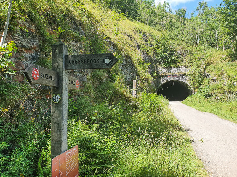
Turn left on the Monsal Trail following the signpost to Wye Dale. Walk down the trail and just before you reach the Cressbrook Tunnel take the footpath on the right heading off the trail. Walk down here then when the path splits, take the left-hand path heading uphill.
Avoid the stile – continue on the Monsal Trail instead of turning off
This is a narrow path that skirts around the edge of the hills, with views to your right of Cressbrook Hall and below you’ll see the Monsal Trail path and the Litton Tunnel, continue walking, over a wooden stile then round the path. You’ll go past a few small caves too.
From here, there’s a path down to the Monsal Trail, keep on the higher path until it splits again, one path leads uphill through the field, keep to the lower path, over a stile and follow this until you pick up the Monsal Trail.

Stage 4 – Monsal Trail to Tideswell Dale
Distance: 1.9 miles/3 km
Grid reference SK 15947 72933
Back on the Monsal Trail for about 1 km, this is where I saw the Common Spotted Orchids! Walk until you see a signpost for Ravenstor, turn right here and follow the rocky stone path downhill to the footbridge over the River Wye. Cross the bridge and turn right onto the footpath.

Walk along the footpath for about 600 metres, then be careful not to walk past your turning. The path is signposted to Tideswell Dale and is just past a small parking area. Turn sharp left here and you’re back on the same footpath that you started on. Walk back along here to Tideswell Dale Car Park.
Buy a printable/downloadable PDF route guide for the walk here.
Let me know if you have any questions for this walk in the comments below.
Other options for this walk
Shorten the walk
If you’d prefer not to do extra ascent and descent with the section below and above the Monsal Trail, you can stay on the trail for 3.2 km instead. The route off the trail is only 0.6 km longer but of course, the Monsal Trail is completely flat!
Note – This walk was initially planned to cross the bridge at Water-cum-Jolly Dale to pick up the footpath on the opposite side above the Monsal Trail. This bridge is currently closed until further notice, which is why the route picks up the Monsal Trail further down (in case you were looking at ways to shorten the route here).
More walks in the Peak District
Want to try more of the Derbyshire Dales walks in the Peak District? You might like these routes nearby from Miller’s Dale and Hartington
Or check out all our Peak District walking routes here
Save me to your Hiking boards on Pinterest


*Peak District Walks participates in the Amazon Services Associates Programme, as well as other affiliate programmes. If you purchase through these, Peak District Walks earn from the qualifying links. This is at no extra cost to you. Read more here.
Peak District Walks is a FREE online resource. Are you enjoying the walks? You can say thank you and buy me a coffee here. Thank you very much 🙂
Peak District charity patches
Read about the charity here.


Charity Patches

Charity Patches

Charity Patches

Charity Patches

Charity Patches

Charity Patches
Need more help planning your Peak District trip?
Join our Peak District walks Facebook page, follow us on Instagram and Twitter for inspiration.
More information on the Peak District, including transport options, where to stay, best Peak District pubs + other useful resources.
Check out the 7 YHAs in the Peak District and find the best walks direct from your accommodation.
Find out what maps you will need for your trip here.
Top tips - Read our useful guides on hiking tips here.
Guided Walks with an introduction to map reading (see dates here).
Visit our hiking recommendations page, (footwear, clothes + kit).
Or get in touch and I will help as best I can :).
Please note 'Peak District Walks' accepts no liability for any injuries or accidents resulting from walking our routes. We always recommend you wear appropriate footwear to avoid injuries and to take a paper map and compass on your walks. Read more here.
Pingback: Bradford Dale Walk From Youlgreave | 6-Mile Route – Peak District Walks