
A lovely 8-mile route exploring four of the Peak District edges from Curbar. There’s some ascent in this walk, but considering the views you have walking along edges it’s well worth it.
As well as the four edges to enjoy, there’s also a trig point on White Edge and even a chance to spot some beautiful Highland Cows so plenty to see on the walk.
From Curbar Gap car park, you first head along Baslow Edge, walking past Wellington’s monument before heading past the spot where the Highland Cows roam. From here, you head up to White Edge and the trig point, then continue along the edge on this quieter part of the walk.
Next the route heads down to The Grouse Inn, a perfect halfway point to stop for refreshments, or simply continue the walk along Froggatt Edge and Curbar Edge back to the start.
Some of our walks require good navigation skills but with the help of the edges this route makes things much easier and less chance of going the wrong way (no guarantee though!)
Here you will find details on how to get to the start of the walk at Curbar, parking options, route information, map, GPX file, plus a detailed step by step guide of the walk.
Ask me any questions about the route in the comments below.
Buy a printable/downloadable PDF route guide for the walk here.
Baslow Edge via White Edge to Curbar Edge walk

Walk information + GPX
Walk type: Medium circular walk
Distance: 8.1 miles/13 km
Walk time: 3.5-4.5 hours
Total ascent: 427 m/1,401 ft
Highest point: 371 m/1,217 ft
Walk highlights: Baslow Edge, Highland Cows, deer rutting (in autumn), Froggatt Edge + Curbar Edge
Trig points: 1 – White Edge
Ethels: 0
Stiles: 0
Four Edges walk map

© Crown copyright and database rights (2024) OS 002572460
Click for online map
Walk start point
Start grid reference: SK 26362 74654
Car parking address: Curbar Gap Car Park, Clodhall Lane, Hope Valley, S32 2YR or S32 3YR
Curbar Gap is a National Trust car park, free for members, if not see costs below. Alternatively further down the road, there are a couple of laybys or on busy weekends there are places you can park along the road. However, there are now double yellow lines in places so please check before you park.
Parking Cost*
- Up to 4 hours – £3.50
- Over 4 hours – £5.00
(*Cash and card payments accepted. Prices correct at time of writing)
Public transport
There are no public transport options to get to the start of this route.

Facilities on the walk
At the start of the walk, there are no public toilets or facilities. The nearest public toilets are in Baslow, a short drive away.
During weekends there’s a hot drinks van at weekends called Jolly’s – they have cakes too! For after your walk there are a few local pubs not too far away in different directions, there’s The Bridge Inn at Calver, the Grouse Inn at Froggatt or the Robin Hood at Baslow.
Other useful information

The Curbar Gap car park and walk are popular during peak times so please note that it’s best to arrive early to guarantee a space.
There’s a good chance you’ll spot a small herd of Highland Cattle on the route around from Baslow Edge. The guidance is to keep dogs in a lead here as the cattle is roaming free.
Please keep the Peak District beautiful and respect everyone who uses the park. Take ALL your rubbish home to dispose of and remember close gates (as you found them). Thank you so much.
Would you know what to do in an emergency situation?

We have a guide with what to do, who you need to call and also some useful kit that should be in your backpack. Ask us any questions in the comments or via our social media.
Happy hiking + stay safe
read here
Peak District weather
Check the weather for your walk location.
- BBC Weather for Curbar
- Met Office weather for the Peak District
- Met Office weather for Eyam Youth Hostel (nearest location) and/or MWIS (Mountain Weather Information Service) for the Peak District.
Ordnance Survey walk map
The map required for this walk is the Ordnance Survey OL24 – Peak District (White Peak Area). Check prices here with Ordnance Survey or Amazon. If you’re hiking in all weathers the Active OS maps are pretty good to have.
And don’t forget your compass, I recommend the Silva Expedition compass or the Silva Classic (cheaper option).
For online maps, I recommend the OS Online App (I have been using it for many years and it is worth getting if you want to start walking more). Check prices here for the one-month or annual option with the OS Online App. All the walks on the website are created using OS Online + you can download them to the App.
Baslow Edge via White Edge, Curbar Edge walk route
Stage 1 – Curbar Gap via Baslow Edge to Clodhall Lane
Distance: 1.8 miles/2.9 km
Grid reference SK 26243 74678
From Curbar Gap car park, turn right walk down the road until you reach a footpath on the left. Walk up, go through the gate then take the first footpath shortly after, bearing right towards Baslow Edge.
As you reach the edge you, to the right, you have beautiful views of Curbar Edge. Continue walking on the footpath as it bears left to the start of the rocky outcrop of Baslow Edge.

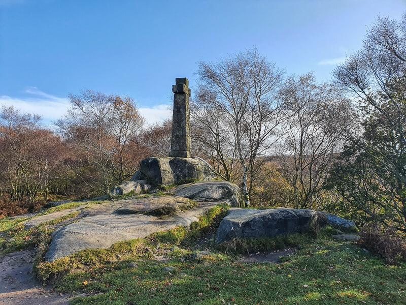
The path follows the edge then after about 1 km, it bears round to the left, bringing you out on a footpath. Keep walking towards Wellington’s Monument (photo below), a stone cross about 100m down the path, erected to celebrate the Duke of Wellington’s victory at the battle of Waterloo.
From here, follow the path, past a small wooded area on the right, alongside a stone wall and on to an open area of land, where you might see the Highland Cattle.
At the end of the wall, you’ll reach a wooden gate next to a large stone boulder, at the road (Clodhill Lane).

Stage 2 – Clodhall Lane to White Edge Trig
Distance: 1.4 mile/2.3 km
Grid reference SK 26223 73630
Go through the gate, straight across the road and through the gate on the other side. Follow the narrow footpath, heading left across the land. As the path splits further up, keep on the right-hand fork, heading slightly uphill. (This part of the route can be muddy in places).

Continue walking until you reach a fingerpost sign for White Edge, pointing straight ahead. Walk up the footpath, after 700 m it splits, which is where the route detours past the White Edge trig point.
Stop for the classic trig point photo!

Stage 3 – White Edge Trig to Grouse Inn
Distance: 2.1 miles/3.3 km
Grid reference SK 26368 75839
From the White Edge trig point continue walking along the edge, it’s a narrow path but it follows the edge so it’s easy to follow. Continue all the way until you reach a gap in the wall, where you’ll see a fingerpost sign for Grouse Inn. Turn left here and walk down next to the wall towards the trees.

The path heads downhill and is rocky in places, so take your time. You’ll reach another fingerpost sign, turn left again, go through a gate and then across a field to another gate which leads to the road.
Turn left, cross the road and go past the pub (or you could pop in for a drink).
Stage 4 – Grouse Inn via Froggatt Edge to Curbar Gap
Distance: 2.7 miles/4.4 km
Grid reference SK 25808 77887
Immediately after the car park on the right there’s a gate leading across the field with a national trust sign for Longshaw Estate. Walk across the field, through two more small gates at the end, then turn left and walk through the wooded area.
Follow the path as it heads downhill, over a small stream and back up the other side. Go through the gate, onto the road. Cross over and turn right taking the footpath on the other side to another gate that leads up away from the road.

Walk along the path, until you reach another gate then shortly after you’re at the start of Froggatt Edge. There are a couple of paths, one near the edge of the main track, pick whichever but keep walking with the edge on your right.
Froggatt Edge ends shortly before Curbar Edge begins. Again you can pick either path as you make your way along the top.

Eventually, you start to head down from the edge to a gate. Go through the gate and at the signpost follow the sign for White Edge (photo above) next to the wall. This is a short cut back to the car park, without going on the road.
Ask me questions about the Four Edges walk in the comments below.
Buy a printable/downloadable PDF route guide for the walk here.
Other options for this walk
Shorten the walk
Looking for a shorter walk? Try our other two routes from Curbar.
- Baslow Edge Short Walk From Curbar Gap | 3-Mile Route
- Curbar Edge Walk From Curbar (+ Froggatt Edge + White Edge) | 6-Mile Route
More walks in the Peak District
Love the trig walks in the Peak District? You might like these circular walks.
- Stanton Moor Plantations + Oaker Hill Trig Walk from Birchover | 10-Mile Route
- Birchen Edge Trig Walk Near Baslow | 2-Mile Route
- Alderman’s Hill Walk (+ Saddleworth Trig) From Greenfield | 3 or 5 Mile Route
Or check out all our Peak District walking routes here
View walks directory herePeak District Walks is a FREE online resource. Are you enjoying the walks? You can say thank you and buy me a coffee here. Thank you very much 🙂
Peak District charity patches
Read about the charity here.


Charity Patches

Charity Patches

Charity Patches

Charity Patches

Charity Patches

Charity Patches
Need more help planning your Peak District trip?
Join our Peak District walks Facebook page, follow us on Instagram and Twitter for inspiration.
More information on the Peak District, including transport options, where to stay, best Peak District pubs + other useful resources.
Check out the 7 YHAs in the Peak District and find the best walks direct from your accommodation.
Find out what maps you will need for your trip here.
Top tips - Read our useful guides on hiking tips here.
Guided Walks with an introduction to map reading (see dates here).
Visit our hiking recommendations page, (footwear, clothes + kit).
Or get in touch and I will help as best I can :).
Please note 'Peak District Walks' accepts no liability for any injuries or accidents resulting from walking our routes. We always recommend you wear appropriate footwear to avoid injuries and to take a paper map and compass on your walks. Read more here.
*Peak District Walks participates in the Amazon Services Associates Programme, as well as other affiliate programmes. If you purchase through these, Peak District Walks earn from the qualifying links. This is at no extra cost to you. Read more here.
Pingback: Shutlingsloe Hill Walk (Via Macclesfield Forest) From Wildboarclough | 5-Mile Route - Peak District Walks
Pingback: 16 Stunning Sunset Walks In The Peak District - Peak District Walks
Pingback: Baslow Edge + Birchen Edge Walk From Baslow | 9-Mile Route - Peak District Walks
Pingback: 7 BEST Walks From Baslow (Short + Long Routes) - Peak District Walks