Birchen Edge walk is the shortest of all our trig walks, so it’s a perfect one to begin your trig bagging challenge. This lovely 2-mile route takes you on a short circular loop from Robin Hood pub near Baslow.
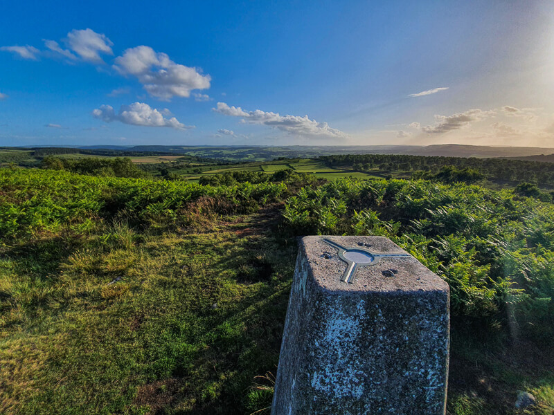
After leaving the car park, it’s not long before you’re walking along the edge and enjoying stunning views from Birchen Edge trig point. As well as seeing the iconic Three Ships rock formation and Nelson’s monument.
From Birchen Edge trig, you head down and reach the second beautiful Peak District edge on this walk, Gardom’s Edge. Although it’s hidden by trees, there are great spots for views across to Baslow Edge in the distance.
Here you will find details on how to get to the start of the walk, route information, a map, a GPX file, plus a detailed step-by-step guide of the walk.
Let me know in the comments if you’ve done this trig walk and what you think!
Buy a printable/downloadable PDF route guide for the walk here or ALL our 2-mile walk routes PDF bundle here.
Birchen Edge from Robin Hood Pub

Walk information + GPX
Walk type: Short circular walk
Distance: 2.2 miles/3.6 km
Walk time: 1-1.5 hours
Total ascent: 136 m/446 ft
Highest point: 310 m/1,017 ft
Walk highlights: Nelson’s Monument, The Three Ships stones, Birchen Edge trig + Gardom’s Edge
Trig pillars: 1 – Birchen Edge
Stiles: Yes – 1
Birchen Edge walk map

© Crown copyright and database rights (2024) OS 002572460
Click for online mapWalk start point
Start grid reference: SK 28032 72135
Car parking address: Birchen Edge car park, Chesterfield Road (A619), nr Baslow, Bakewell, DE45 1PU – Google maps
The car park is right next to the Robin Hood Inn. It’s not a huge car park (about 30 spaces) so it can be busy at weekends but since most of the walks are short people come and go throughout the day.

Parking cost (Correct as of March ’23)
2 Hours – £4.60
Free for National Trust Members
Public transport
The 170 bus service runs between Chesterfield and Bakewell and stops near the Robin Hood Pub. There are no train stations nearby.
Facilities on the walk
There are no public toilets available at the start of the walk at Birchen Edge car park. The nearest public toilets are down the road at Nether End car park in Baslow. Or alternatively, treat yourself to a drink and some food at the end of your walk in the pub and you can use their facilities!

Other useful information
A lovely short walk that’s relatively easy to follow and not get lost, but we do recommend you always take a map with you on our walks (see below for details).
In the summer drier months, the trail is lovely to walk on but in the wetter months, the trail up to Birchen Edge (and down) can be muddy and slippy so worth taking your time to avoid twisted ankles.
There are also a few steep drops, especially along Gardom’s Edge, worth noting if you’re walking with younger children.
Peak District weather
Check the weather for your walk location and hills. We’d recommend that you check a few resources and for hill walks look at the weather conditions in the valley and on the hilltop as they can greatly vary.
- BBC Weather for Baslow
- Met Office weather for Baslow, Derbyshire
- Met Office weather or MWIS (Mountain weather information service) for the Peak District
Ordnance Survey walk map
The map required for this walk is the Ordnance Survey OL24 – Peak District (White Peak Area). Check prices here with Ordnance Survey or Amazon. If you’re hiking in all weather the Active OS maps are good to have as they are laminated so better on rainy days.
And don’t forget your compass, I recommend the Silva Expedition or the Silva Classic compass.
For online maps, I recommend OS Online App (I have been using it for many years and it is worth getting if you want to start walking more). Check prices here for the one-month or annual option with OS Online App. All the walks on the website are created using OS Online + you can download them to the App.
See both maps that cover the Peak District here.
Want to learn more map skills? Check out our Guided Walks with map reading skills here.
Buy a printable/downloadable PDF route guide for the walk here or ALL our 2-mile walk routes PDF bundle here.
Birchen Edge walk route
Stage 1 – Birchen Edge car park to Birchen Edge Trig
Distance: 0.8 miles/1.25 km
Grid reference SK 28028 72135
From the car park, head down the steps towards the road. Turn left following the signpost for Birchen Edge. After 100 m, turn left and head along the narrow footpath. After another 500 m the footpath splits, take the right-hand fork up the steep path.

The path winds gradually uphill through some thick heather and bracken, but eventually, it brings you out at three large rock formations, known as the Three Ships and Nelson’s monument.
Another 100 m further along the edge you’ll reach Birchen Edge trig point, at 310 m.

Stage 2 – Birchen Edge Trig to Car Park
Distance: 1.5 mile/2.4 km
Grid reference SK 27834 73094
Once you’ve enjoyed the great views from Birchen Edge trig, it’s time to head down. From the trig, take the narrow path heading downhill, straight ahead.
Bear right then left on the path past the large boulder. Walk on the path through a large grassy area with trees. Follow these faint paths across heading west and don’t forget to glance back towards Birchen Edge.

After 700 m, you’ll reach a gate in a dry stone wall. Go through and you’ll come out onto Gardom’s Edge. Turn left through the hole in the wall and continue along the footpath as it heads next to the edge past trees and the edge.
Continue for about 700 m as the views disappear, and you’ll come across another gate in the wall on the left. Go through this gate and follow the path all the way to the stone stile in the wall. Turn left along the pavement and you’ll be back at the Robin Hood Pub and car park.

Ask me questions about the Birchen Edge walk in the comments below.
Buy a printable/downloadable PDF route guide for the walk here or ALL our 2-mile walk routes PDF bundle here.
Other options for this walk
Extend the walk
Here’s an option to do a really long walk! The 9 Edges challenge ends at Birchen Edge but as you’ve guessed from the name it includes 8 other Peak District edges!
More walks in the Peak District
Love the walks along the Peak District edges? You might like these walks.
- Derwent Edge from Fairholmes
- Burbage Edge from Upper Burbage
- Curbar Edge + Froggatt Edge walk from Curbar
Or check out all our Peak District walking routes here
Peak District Walks is a FREE online resource. Are you enjoying the walks? You can say thank you and buy me a coffee here. Thank you very much 🙂
Peak District charity patches
Read about the charity here.


Charity Patches

Charity Patches

Charity Patches

Charity Patches

Charity Patches

Charity Patches
Need more help planning your Peak District trip?
Join our Peak District walks Facebook page, follow us on Instagram and Twitter for inspiration.
More information on the Peak District, including transport options, where to stay, best Peak District pubs + other useful resources.
Check out the 7 YHAs in the Peak District and find the best walks direct from your accommodation.
Find out what maps you will need for your trip here.
Top tips - Read our useful guides on hiking tips here.
Guided Walks with an introduction to map reading (see dates here).
Visit our hiking recommendations page, (footwear, clothes + kit).
Or get in touch and I will help as best I can :).
Please note 'Peak District Walks' accepts no liability for any injuries or accidents resulting from walking our routes. We always recommend you wear appropriate footwear to avoid injuries and to take a paper map and compass on your walks. Read more here.
*Peak District Walks participates in the Amazon Services Associates Programme, as well as other affiliate programmes. If you purchase through these, Peak District Walks earn from the qualifying links. This is at no extra cost to you. Read more here.
A lovely walk thanks Becky. Just what we needed steady enough with stunning views
Ah wonderful thanks Glynn, yeah, it’s perfect to get those hiking legs working again 🙂 Thanks