Kinder Scout is a huge moorland plateau in the Peak District and it’s also the highest point in the National Park at 636 metres.
In fact, it’s so big to walk around the entire Kinder plateau, over 25 km in distance and that’s not counting the hike up and down. There are also over 20 paths marked on the Ordnance Survey to reach the top.
Kinder Scout is a popular place for hikers to go, due to it being the highest spot in the Peak District and the beautiful views from the top. The most common routes up to the plateau are from the two lovely villages of village of Edale and also Hayfield.
But in times when we might be looking for less-popular routes then why not try this Kinder Scout walk, exploring the northern side of the plateau?
Here you will find details on how to get to the start of the walk at Snake Pass, where to park, route information, facilities on the walk, plus a detailed step by step guide of the walk.
Note: Snake Pass will be closed for road repairs from 14th-25th October 2024.
Let me know in the comments if you’ve done this walk and what you think!
Kinder Scout walk from Snake Pass

Walk information + GPX
Walk type: Medium circular walk
Distance: 8 miles/13 km
Walk time: 4-5 hours
Total ascent: 694 m/2,276 ft
Highest point: 618 m/2,027 ft
Walk highlights: Fair Brook with mini waterfalls, Rock formations along ‘The Edge’ of Kinder Scout, views from Kinder plateau and looking back up as you descend Ashop Clough
Trigs: 0 (nearest Edale Moor)
Ethels: 0
Stiles: 1
gpx file
Kinder Scout walk map

© Crown copyright and database rights (2024) OS 002572460
Click for OS online mapWalk start point
Start grid reference: SK 11264 90523
Car parking location: Snake Pass Inn (no longer open but marked on OS map), Snake Road (A57), Hope Valley, S33 0BJ
There is no parking at Snake Pass Inn; however, free parking is available at numerous laybys on the side of the road, suitable for between 3-5 car at each one.
Alternatively, there is a free car park further down the road but this will involve extending the walk.

Public transport
Unfortunately, there are no suitable public transport options for this walk, which is one of the reasons this is another less-popular route.
Facilities on the walk

There are no public toilets available at the start of the walk at Snake Pass or on any of the walk.
This is a remote section of the Peak District and there are also no refreshments on the walk either. Please take all your own food and water (and also remember to bring home too).
I filled up my water in Fair Brook, using my Water-to-Go filter water bottle. Ask me any questions in the comments.
Other useful information
Please note that this route does include a short section walking next to the busy A57 road, depending on where you end up parking.
Kinder Scout plateau is beautiful on a clear day but it bad weather it can be difficult to navigate, as well as being very cold due to how exposed it is. Take some extra layers for the top.
I always recommend you take a map and compass (see below).
Please keep the Peak District beautiful and respect everyone who uses the park. Take ALL your rubbish home to dispose of and remember close gates (as you found them). Thank you so much.
Would you know what to do in an emergency situation?

We have a guide with what to do, who you need to call and also some useful kit that should be in your backpack. Ask us any questions in the comments or via our social media.
Happy hiking + stay safe
read herePeak District weather
Check the weather for your walk location and hills. The weather on the top of Kinder Scout can vary greatly to the start of the route.
- BBC Weather for Glossop
- Met Office weather for the Peak District
- Met Office weather for Kinder Low (opposite side of Kinder Scout) and/or MWIS (Mountain Weather Information Service) for the Peak District
Kinder Scout patch
An iconic view of the packhorse bridge at Jacob's Ladder on the way up to Kinder Scout summit.
Celebrate reaching the highest point in the Peak District with our second charity patch.
Or if you are planning on doing the walk soon, order the patch now so you can take it to the top for a photo.
visit shop
Charity Patches
Ordnance Survey Walk Map
The map for this walk is OL1 – Peak District (Dark Peak Area)
You can buy a paper map at outdoor shops or shop online at Amazon or Ordnance Survey
Check prices here with Ordnance Survey, there are options to buy either standard map or a waterproof one. You can sometimes find cheaper deals on Amazon, but the Ordnance Survey website sometimes has discounts for buying more than one map!
And don’t forget your compass, I recommend the Silva Expedition or the Silva Classic compass.
For online maps, I recommend the OS Online App (I have been using it for many years and it is worth getting if you want to start walking more). Check prices here for the one-month or annual option with the OS Online App. All the walks on the website are created using OS Online + you can download them to the App.
Check prices here for the one month or yearly option with OS Online App.
Read later? Save the walk to Pinterest

Kinder Scout walk route
Stage 1 – Snake Pass to Kinder Scout Plateau
Distance: 1.9 miles/3.1 km
Grid reference SK 11451 90286
Depending on which layby you parked in, you’ll either need to walk up or down the road (the grid reference is the point where the public footpath is).
At this point go through the gate, on the map. It shows as a wooded area but you’ll notice this area has now been logged. Make your way down to a gate (slightly obscured) and over a small wooden bridge.

Then turn left at the National Trust sign, follow the path round to Fairbrook and continue walking all the way alongside the brook. As you ascend there are a few sections along the walk you can stop to cool off in the water, including a few mini dammed off sections.
The path then continues running parallel to the brook but starts ascending until you reach a rocky section which takes you up to the top of Kinder Scout via a small gate then on to the plateau.

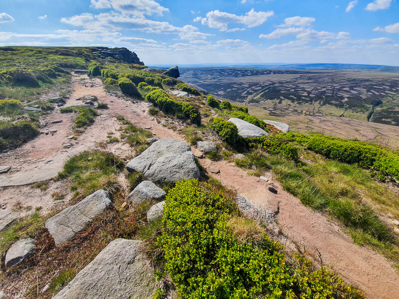
Stage 2 – Kinder Scout Plateau to Pennine Way
Distance: 2.7 mile/4.3 km
Grid reference SK 09327 89110

Once you reach Kinder Scout plateau you then head in a northerly direction, heading towards some large flat rocks on the edge.
From here you then bear left all the way along ‘The Edge’ of Kinder Scout. The path takes you pretty close to the edge and along past several lovely rock formations.

After about 3 km you’ll reach a stile, then shortly after you’ll join the busier section (for a few hundred metres) on the Pennine Way trail.
At the Pennine Way, turn right, down to the large stone cairn and then descend where there are several paths. Keep on the right-hand path all the way to a wooden post, signposted Snake Inn.
Stage 3 – Pennine Way via Ashop Clough to Snake Pass
Distance: 3.5 miles/5.7 km
Grid reference SK 06435 90087
Turn right at the signpost, then follow the path down Ashop Clough. The path can be boggy in a few places, especially in wet weather!

Walk all the way to a small wooded area, go through a gate then across a wooden bridge.
Keep on the same side of the fence and follow it round to another gate which then takes you back uphill through the Snake Woodlands and out on to Snake Road.

From here, turn right and follow the road back to the layby, there is a short section of pavement, but the rest you just need to keep close to the verge.
Do you have any more questions about this Kinder Scout walk, maybe what to wear on your hike or any other questions? Ask me in the comments below.
More walks in the Peak District
Love the walks in the Peak District? You might like these Peak District circular walks.
Or check out all our Peak District walking routes here
Save me to your Hiking boards on Pinterest


*Peak District Walks participates in the Amazon Services Associates Programme, as well as other affiliate programmes. If you purchase through these, Peak District Walks earn from the qualifying links. This is at no extra cost to you. Read more here.
Peak District Walks is a FREE online resource. Are you enjoying the walks? You can say thank you and buy me a coffee here. Thank you very much 🙂
Peak District charity patches
Read about the charity here.


Charity Patches
Charity Patches

Charity Patches

Charity Patches

Charity Patches

Charity Patches
Need more help planning your Peak District trip?
Join our Peak District walks Facebook page, follow us on Instagram and Twitter for inspiration.
More information on the Peak District, including transport options, where to stay, best Peak District pubs + other useful resources.
Check out the 7 YHAs in the Peak District and find the best walks direct from your accommodation.
Find out what maps you will need for your trip here.
Top tips - Read our useful guides on hiking tips here.
Guided Walks with an introduction to map reading (see dates here).
Visit our hiking recommendations page, (footwear, clothes + kit).
Or get in touch and I will help as best I can :).
Please note 'Peak District Walks' accepts no liability for any injuries or accidents resulting from walking our routes. We always recommend you wear appropriate footwear to avoid injuries and to take a paper map and compass on your walks. Read more here.
Pingback: Kinder Scout Walk From Edale (via Grindsbrook Clough) | 8-Mile Route - Peak District Walks
Pingback: Edale to Kinder Downfall Circular Walk (+ Kinder Reservoir) | 15-Mile Route - Peak District Walks
Pingback: Derwent Edge Circular Walk (via Lost Lad + Back Tor) | 8-Mile Route - Peak District Walks
Pingback: Laddow Rocks + Black Hill via Pennine Way From Crowden | 9-Mile Route - Peak District Walks
Pingback: Snake Woodlands, Higher Shelf Stones Long Walk | 14-Mile Route – Peak District Walks
Pingback: 15 BEST Peak District Waterfalls (+ Walks to Visit Them) – Peak District Walks