
The Peak District can be a very busy place with parking spots in some places filling up fast. We always like to make the start of our Peak District Walks easy to find and access. In every walk description you’ll find the best places to park for the walk, but did you realise we also give details of how to reach the start by public transport?
Some of our Peak District walks are easier to reach by public transport than others. If you’re wanting to use the bus or train to head to the start of your hike, we’ve chosen ten of our routes which are easiest to access.
Let me know in the comments if you’ve got a favourite walk to do by public transport!
Best Peak District Walks Accessible by Public Transport
Below you’ll find our top ten walks to access by public transport in the Peak District. We’re giving you a brief overview of that walk, along with information on which bus or train to get to the start.
You can click through to the main walk description for the full route information, map and GPX.
1. Padley Gorge, Higger Tor + Stanage Edge Walk From Hathersage – 12 mile route

This walk starts alongside the beautiful River Derwent, subsequently leading to Grindleford Station. From here you head through Padley Gorge, a hidden treasure of trickling streams and woodlands before going out to open moorlands.
At Surprise View you’ll get beautiful views across the Hope Valley and hills beyond. Following Millstone Edge with the iconic, Over Owler Tor, gritstone rocks on your right, you continue towards Higger Tor.
From Higgor Tor summit you can see the iconic Stanage Edge stretching out for miles on your left, the route takes you down and then up to the edge for the end of your walk.
Nearest train station: Hathersage train station is close to the centre of Hathersage so you could start the walk if you’re travelling by train – Google location You can also start the walk from Grindleford train station which is on the walk.
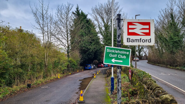
Walk route + map here2. Stanage Edge, Derwent Edge + Ladybower Reservoir Walk From Bamford – 14 Mile Route

On this walk you head out from Bamford train station to leave the village on a gradual uphill to pick up the footpath along Stanage Edge, nabbing some great views and High Neb trig point! Heading downhill through farmland to join the path up to Derwent Edge, then up to the Wheel Stones.
Head back down the path with stunning views of Ladybower Reservoir and down through the the woods to come out at the Ladybower Inn. You then have a flat section alongside the reservoir towards the ‘Plug hole’, before crossing Ladybower Dam and following the Thornhill Trail back to Bamford Station.
Bamford train station is the start of the walk. You can catch a train direct from either Sheffield (22 minutes) or Manchester (53 minutes).
Walk route + map here3. Stanton Woodhouse from Rowsley
This 4.5-mile walk takes you out from the village of Rowlsey uphill to Stanton Woodhouse with its old manor house. You’ll get great views of Matlock and Haddon Hall for much of your route.
On your way back you pass through the tiny hamlet’s of Pilhough and Congreave, with just over ten houses between them. You also pass Peak Tor, a mysterious tree-topped hill summit, also known as Pillow Hill, which is thought to have been an early Celtic settlement.
The TrentBarton Sixes bus serves Rowsley regularly throughout the day on its route between Bakewell and Derby. The Peak Village stop on the A6 is very close to the start/finish of the walk.
Walk route + map here4. Win Hill + Kinder Plateau Walk From Hope To Edale
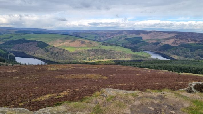
This lovely linear walk is ideal for those using public transport, as it starts from one train station and ends at another! On the way it takes in the delights of Win Hill, views of Ladybower Reservoir, and Crookstone Hill via the Kinder Plateau.
This walk is designed for you to either drive or catch the train to the start point at Hope station, then from the finish at Edale to catch the train back to Hope. Or back to wherever you got the train from that morning! It is a 7 minute journey between the two stations and the trains are approximately once an hour (check times here via Trainline).
Walk route + map here5. Hollins Cross + Mam Tor Short Walk From Edale

Heading out from Edale, this is a great short walk to do up the popular hill of Mam Tor. You can start from the train station in Edale to make your way up to your high point at Hollins Cross. From here, you can enjoy this viewpoint in all directions, seeing the scale of Mam Tor against the old broken road which is visible from this spot. And also looking down to the village of Castleton and Hope Cement Factory in the distance.
Edale Station is located right near the start of this walk, with regular trains from Manchester and Sheffield.
Walk route + map here6. Black Rocks and Star Disc from Wirksworth

This walk is ideal for accessing by bus and at only 4.5-miles long you’ll have time to enjoy the delights of Wirksworth before getting the bus home. Leaving Wirksworth, you climb steadily up to reach the little village of Bolehill and Bolehill trig point. From there you head through woods to come out at Black Rocks, with amazing views.
You start to drop back down, past the National Stone Centre, on the High Peak Trail, leaving the trail to cross fields back towards Wirksworth. Before reaching the village you take in the final feature of your route, the Star Disc, an illuminated 21st century stone circle star chart that mirrors the northern hemisphere’s night sky.
The TrentBarton Sixes bus serves Wirksworth regularly throughout the day on its route between Bakewell and Derby. The Market Place stop in the village is very close to the start/finish of the walk.
Walk route + map here7. Chatsworth Hunting Tower Walk From Baslow

Take the bus from Bakewell or Buxton to get to the start of this lovely short walk. It’s a great one to do if you’re planning on visiting Chatsworth House and Gardens and want to make a day of it.
You head into Chatsworth Park then into Stand Woods. The route takes you via Chatsworth Hunting Tower then on to the aqueduct, it’s a lovely route for all weathers, as in warm weather there’s shade from the trees, and on rainy days you’ll have some shelter.
There are buses that stop in Baslow that go between Bakewell and Buxton. See timetable for the X70 bus service here.
Walk route + map here8. Kinder Scout Walk From Hayfield (+ Kinder Downfall)

On this route from Hayfield, you begin walking up the road, with a short steep hill to wake your legs up before skirting alongside Kinder Reservoir. At the end of the reservoir you make your way up the narrow winding path of William Clough. At the top there’s another uphill to the edge of the Kinder Plateau, where you can enjoy the views.
The route goes via Kinder Downfall, and from here you head via Kinder Low trig point. You can detour off to the official Kinder Scout summit from here. Then it’s heading back past Edale Rocks to pick up a bridleway back to Hayfield.
The High Peak service no. 61 bus runs between Glossop and Buxton and stops at Hayfield bus station, so you can begin the route from there alongside the River Kinder (about a mile from Bowden Bridge car park).
Walk route + map here9. Magpie Mine Walk (+ Monsal Dale) From Ashford-in-the-Water

Fancy checking out a lead mine, which is hundreds of years old? This is a great walk which visits Magpie Mine, as well as going through the quiet valley of Deep Dale. You also walk through Monsal Dale and alongside the River Wye.
Heading towards the Monsal Viaduct, where you walk up to join the Monsal trail, then through the Headstone tunnel. Finally, you’ll leave the Monsal Trail, heading across fields and back to the start at Ashford-in-the-Water.
The TransPeak bus goes between Buxton and Bakewell and stops in Ashford-in-the-Water approximately every hour throughout the day, making it a perfect way to get to the start of your walk.
Walk route + map here
Do you have any more questions about these walks? Ask me in the comments below.
Ordnance Survey Walk Maps
For these walks, there are two maps that cover them OL1 – Peak District (Dark Peak Area) and OL24 – Peak District (White Peak Area)
Shop online at Ordnance Survey
And don’t forget your compass, I recommend the Silva Expedition or the Silva Classic compass.
For online maps, I recommend the OS Online App (I have been using it for many years and it is worth getting if you want to start walking more). Check prices here for the one-month or annual option with the OS Online App. All the walks on the website are created using OS Online + you can download them to the App.
Check prices here for the one month or yearly option with OS Online App.
More walks in the Peak District
Love a Peak District walk collection? You might like the pages below.
- Cool Cave walks in the Peak District
- 15 Best Waterfall walks in the Peak District
- Beautiful Peak District villages to begin your walk from
- Stunning sunset walks in the Peak District
Or check out all our Peak District walking routes here
*Peak District Walks participates in the Amazon Services Associates Programme, as well as other affiliate programmes. If you purchase through these, Peak District Walks earn from the qualifying links. This is at no extra cost to you. Read more here.
Peak District Walks is a FREE online resource. Are you enjoying the walks? You can say thank you and buy me a coffee here. Thank you very much 🙂
Peak District charity patches
Read about the charity here.


Charity Patches

Charity Patches

Charity Patches

Charity Patches

Charity Patches

Charity Patches
Need more help planning your Peak District trip?
Join our Peak District walks Facebook page, follow us on Instagram and Twitter for inspiration.
More information on the Peak District, including transport options, where to stay, best Peak District pubs + other useful resources.
Check out the 7 YHAs in the Peak District and find the best walks direct from your accommodation.
Find out what maps you will need for your trip here.
Top tips - Read our useful guides on hiking tips here.
Guided Walks with an introduction to map reading (see dates here).
Visit our hiking recommendations page, (footwear, clothes + kit).
Or get in touch and I will help as best I can :).
Please note 'Peak District Walks' accepts no liability for any injuries or accidents resulting from walking our routes. We always recommend you wear appropriate footwear to avoid injuries and to take a paper map and compass on your walks. Read more here.