
There are numerous routes up to Kinder Scout in the Peak District, this one along with Grindsbrook from Edale is up there with my favourites!
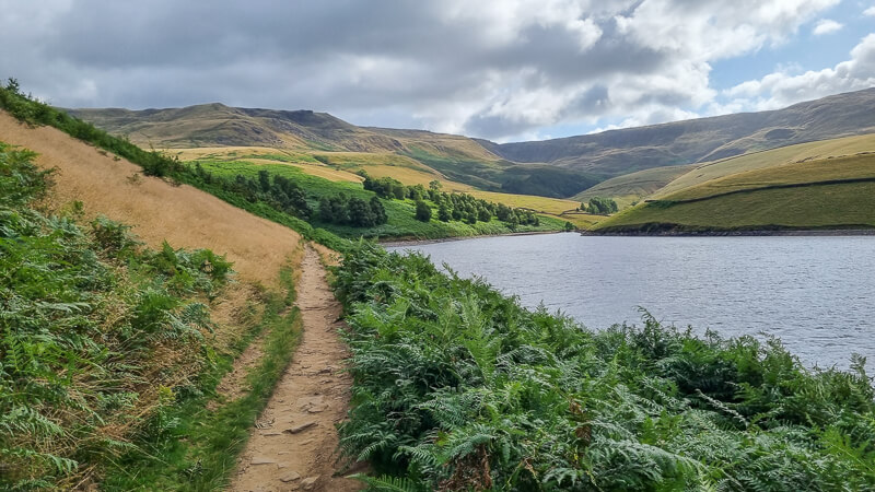
From Hayfield, you begin walking up the road then there’s a short steep hill to wake your legs up before skirting alongside Kinder Reservoir. On a clear day, you can see the edge of the Kinder Plateau on your right. At the end of the reservoir, here’s where the uphill section begins.
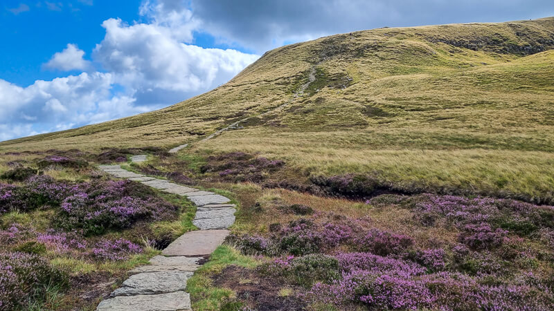
You make your way up the narrow winding path of William Clough, at the top there’s another uphill to the edge of the Kinder Plateau, now you can enjoy the views, whilst finally catching your breath!
The route goes via Kinder Downfall, which could be a backwards waterfall or it could be a tiny trickle of water depending on the weather. From here you head via Kinder Low trig point. You can detour off to the official Kinder Scout summit from here. Then it’s heading back past Edale Rocks to pick up a bridleway back to Hayfield.
Here you will find details on how to get to the start of the walk at Hayfield, route information, a map, a GPX file, plus a detailed step-by-step guide of the walk.
If you prefer an adventurous route, we have a scramble up Red Brook which is a great route, it’s a similar distance but best enjoyed in dry weather!
Let me know in the comments if you’ve done this walk from Hayfield and what you think!
Buy a printable/downloadable PDF route guide for the walk here.
Kinder Scout walk from Hayfield
Walk information + GPX
Walk type: Medium circular walk
Distance: 8.6 miles/13.9 km
Walk time: 4.5-5.5 hours
Total ascent: 596 m/1,968 ft
Highest point: 633 m/1,784 ft
Walk highlights: Kinder Reservoir, William Clough, Kinder Downfall, Kinder Low trig point, Edale Rocks
Trigs: 1 – Kinder Low (Option to add The Edge trig on Kinder Plateau)
Ethels: 0 – (Option to add Kinder Scout)
Stiles: 0
Kinder Scout walk map

Walk start point

Start grid reference: SK 04856 86921
Car parking address: Bowden Bridge car park, 165 Kinder Road, Hayfield, High Peak, SK22 2LH – Google location
This is a small car park which can get busy during peak times. Alternatively, there’s some street parking available on the road with the Sportsman pub.
Parking cost – cash only (9 am to 6 pm)*
- Up to 1 hour – £1.50
- 1-2 hours £2.50
- 2-4 hours £4.00
- All day £4.75
*Prices correct at the time of writing
Public transport
The nearest train station is Glossop (6 miles/10 km). From here, you can then catch the no. 61 bus (High Peak service) from Glossop to Hayfield bus station, so you can begin the route from there alongside the River Kinder (about a mile from Bowden Bridge car park).
Facilities on the walk

There are public toilets available at the start of the walk at Bowden Bridge, Hayfield, a small block opposite the car park at the entrance to Hayfield Campsite and also toilets at Hayfield car park, although this is almost at the end of the walk.
Other useful information
The temperature and wind conditions on the Kinder Plateau can greatly vary from Hayfield, see weather forecasts below and make sure you pack a warm layer.
The beginning of the walk has a good chunk of uphill until you reach the edge of the Kinder Plateau, it’s worth taking some layers off for this section so you don’t get too hot!
Peak District weather
The weather can vary widely from Hayfield town to the top of the hills so please check the conditions and make sure you have warm/waterproofs if necessary.
- BBC Weather for Hayfield
- Met Office weather for Kinder Low
- Met Office weather and/or MWIS (Mountain weather information service) for the Peak District
Ordnance Survey walk map
The map for this walk is the Ordnance Survey OL1 – Peak District (Dark Peak Area). Check prices here with Ordnance Survey or Amazon. If you’re hiking in all weather the Active OS maps are good to have.
See both Peak District maps here.
And don’t forget your compass, I recommend the Silva Expedition or the Silva Classic compass.
For online maps, I recommend OS Online App (I have been using it for many years and it is worth getting if you want to start walking more). Check prices here for the one-month or annual option with OS Online App. All the walks on the website are created using OS Maps Online + you can download them to the OS Maps App.
Win Hill patch
A stunning view from Win Hill summit complete with trig point, looking towards the Derwent Valley and Ladybower Reservoir. Have you climbed this hill? Treat yourself to the patch! Or if you are planning on doing the Win Hill walk soon, order a patch so you can take it to the top for a photo. visit shop
Charity Patches
Kinder Scout walk route
Buy a printable/downloadable PDF route guide for the walk here.
Stage 1 – Hayfield to William Clough
Distance: 1.6 miles/2.5 km
Grid reference SK 04856 86921
From Bowden Bridge car park turn left and walk up Kinder Road alongside the River Kinder, it’s unlikely there will be any traffic but keep an eye out. Walk until you reach two gates and go through the wooden gate, leading to a short and steep uphill path to access land.
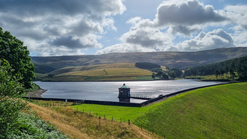
Walk until Kinder Reservoir comes into view on your right. Then head further up through a small gate and take the footpath bearing left, follow this path down next to the stone wall next to the reservoir. On your your right and you can see the Kinder Plateau high above.
The path curves round to the left then brings you out at the top of the reservoir near a small bridge, which is the start of William Clough.
Stage 2 – William Clough to Kinder Downfall
Distance: 2.5 mile/4 km
Grid reference SK 0596 8873
Don’t cross the bridge, instead begin your ascent up William Clough next to the small signpost. It’s a narrow path that heads up the clough and often splits off into different paths, crossing back and forward across the water but they all link back up so pick the route you’re most comfortable with.
In terms of distance, it’s about 1.5 km, but the steep (200 metres ascent) and windy path means it’ll take you longer than you think!

Towards the top you’ll walk up some steps before it brings you out where the path splits. Take the right-hand path that brings you out next to the main footpath heading up to the west side of Kinder Plateau. Hike up here (you’re now on the Pennine Way path for a while), past the cairn then you’ll have done most of the ascent on the walk. Yippee!
Follow the footpath as it winds along the edge, after about 1 km, you can have the option to detour to The Edge trig point (off-path), not visible from the path but only a few hundred metres away.
Keep following the rocky path and eventually, you’ll reach the point where the path turns right at Kinder Downfall. You’ll need to cross the water, sometimes it’s very easy but after heavy rain please take care.

Stage 3 – Kinder Downfall to Swine’s Back
Distance: 1.9 miles/3.1 km
Grid reference SK 0830 8895
From Kinder Downfall, continue along the west side of Kinder Plateau, after about 2 km the path splits, bear off left and follow this path as it will take you directly to the trig called Kinder Low.
Kinder Scout detour – from here you can do a short out and back (off-path) to the official summit of Kinder Scout, an extra 3 metres of ascent!
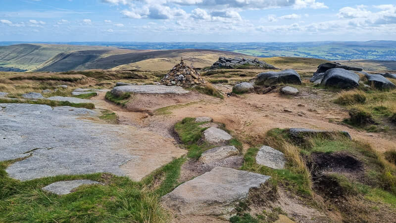
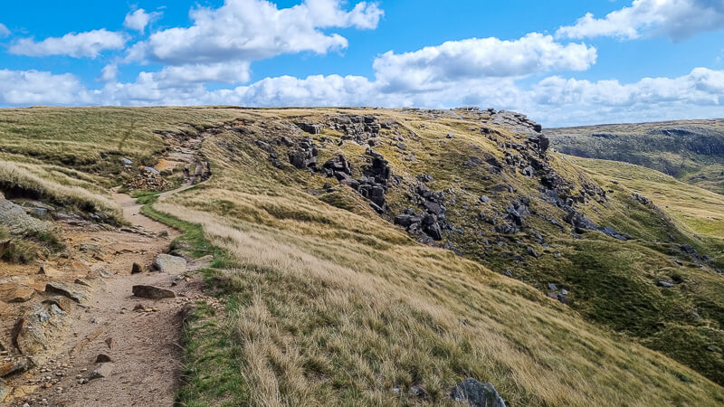
Now from Kinder Low follow the footpath heading south past a cairn which leads towards Edale Rocks, a prominent gritstone formation and a good place to shelter for a quick snack in bad weather.
Continue on the path heading down from Edale Rocks, you’ll walk past a cairn, and shortly after you’ll leave the main Pennine Way footpath and take the right-hand path that splits off heading uphill and over Swine’s Back. It’s a short up and down which you can miss out in bad weather but the views are beautiful at the top so worth it on a good day.
Stage 4 – Swine’s Back to Hayfield
Distance: 2.7 miles/4.4 km
Grid reference SK 0788 8629
From the top of Swine’s Back simply follow the edge which leads you down off the other side, head downhill towards the wall and then through a gate at the bottom which brings you out on a bridleway. At this junction behind the wall, you’ll see Edale Cross, which is an old boundary marker.

At the bridleway turn right and walk down the track, there are a few other footpaths leading from it but stay on the wider established bridleway gradually descending.
Keep walking all the way down the bridleway, you’ll go past a few trees then you will walk down the road, with the trees on your left and you’ll come to a cattle grid, go through the gate next to it, then at the road turn left.

Follow this down until you reach the River Kinder and turn left again with the river on your right. Walk down towards the caravan park and just before you reach it turn right and you’re back at the car park.
Buy a printable/downloadable PDF route guide for the walk here.
Ask me any questions about this walk in the comments below.
More walks in the Peak District
Love the walks in the Peak District? You might like these walks in the Dark Peaks.
- Win Hill + Kinder Plateau Walk From Hope To Edale | 9-Mile Route
- Mam Tor Via Jacob’s Ladder Walk From Edale | 10-Mile Route
- Laddow Rocks + Black Hill via Pennine Way From Crowden | 9-Mile Route
- Harry Hut + Lantern Pike Trig Walk From Hayfield | 10-Mile Route
Or check out all our Peak District walking routes here
Peak District Walks is a FREE online resource. Are you enjoying the walks? You can say thank you and buy me a coffee here. Thank you very much 🙂
Peak District charity patches
Read about the charity here.


Charity Patches

Charity Patches

Charity Patches

Charity Patches
Charity Patches

Charity Patches
Need more help planning your Peak District trip?
Join our Peak District walks Facebook page, follow us on Instagram and Twitter for inspiration.
More information on the Peak District, including transport options, where to stay, best Peak District pubs + other useful resources.
Check out the 7 YHAs in the Peak District and find the best walks direct from your accommodation.
Find out what maps you will need for your trip here.
Top tips - Read our useful guides on hiking tips here.
Guided Walks with an introduction to map reading (see dates here).
Visit our hiking recommendations page, (footwear, clothes + kit).
Or get in touch and I will help as best I can :).
Please note 'Peak District Walks' accepts no liability for any injuries or accidents resulting from walking our routes. We always recommend you wear appropriate footwear to avoid injuries and to take a paper map and compass on your walks. Read more here.
*Peak District Walks participates in the Amazon Services Associates Programme, as well as other affiliate programmes. If you purchase through these, Peak District Walks earn from the qualifying links. This is at no extra cost to you. Read more here.
Thanks Becky your email inspired our walk up Kinder. I’m not one for normally following walk instructions but yours always look so interesting. We almost followed your route entirely with just a few diversions.
Although if I did it again I’d miss out the bridal path with its pebbles in favour of footpaths to Tonsyead Clough Fm.
Thanks again.
Ah thanks Rod, I’m glad you enjoyed the walk and found it easy to follow 🙂
This is a lovely route Becky which I did with my 2 brothers last Friday. Bit murky but very atmospheric. Thank you so much.
Ah thank you David, I’m pleased you enjoyed the route, even if it was a bit murky! Happy hiking 🙂