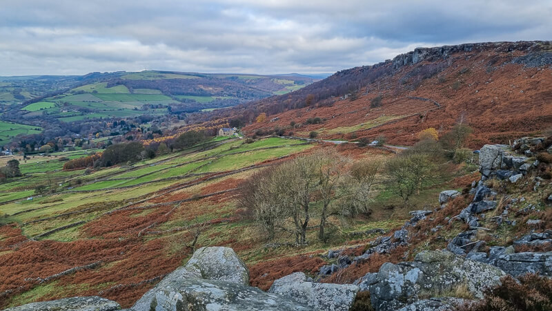
Baslow Edge is a beautiful outcrop of gritstone rocks in the Peak District, which makes it one of the Peak District Edges!
There are several popular edge walks in the Peak District, but Baslow Edge is one of my favourites. It’s not as busy as well-known Stanage Edge or nearby Curbar Edge, but has equally stunning views and is certainly worth adding to your list.
This short walk from the idyllic town of Baslow takes you on a route exploring both below and above Baslow Edge so you have a fantastic perspective from all angles! Once you’ve enjoyed your walk, there’s plenty more to explore around Baslow itself and maybe pop in one of the pubs or cafes.
Fancy a longer walk along Baslow Edge? You can find all our Baslow Edge walks here or view all our walks from Baslow village here.
Let me know in the comments if you’ve done this walk from Baslow and what you think!
Buy a printable/downloadable PDF route guide for the walk here.
Baslow Edge from Baslow

Walk information + GPX
Walk type: Short circular walk
Distance: 3.9 miles/6.3 km
Walk time: 1.5-2.5 hours
Total ascent: 225 m/738 ft
Highest point: 315 m/1,033 ft
Walk highlights: Views of Baslow Edge from below and above, views towards Curbar Edge.
Trig points: 0
Ethels: 0
Stiles: 1
Baslow Edge short walk map

© Crown copyright and database rights (2024) OS 002572460
© Crown copyright and database rights 2021
Click for online map
Walk start point
Start grid reference: SK 25823 72083
Car parking address: Nether End car park, Church Lane, Baslow, DE45 1SR – Google location
This is a medium sized paid car park, peak costs (see below*) apply between 8 am to 6 pm. Evening parking is £1.20 between 6 pm and 8 am. There is a cash, card option to pay or pay by phone; however, the card option hasn’t worked each time I’ve visited. I’d recommend taking cash!
- Up to 1 hour £1.70
- Up to 2 hours £2.70
- Up to 3 hours £4.00
- Up to 4 hours £5.20
- All day £6.20
*Prices correct as of March 2023.

Public transport
There’s no train station in Baslow, however there are buses that stop in Baslow that go between Bakewell and Buxton. See timetable for the X70 bus service here.
Facilities on the walk
There are public toilets available at the start of the walk at Baslow; however there are no other toilets on the route.
At Curbar Gap car park, a short distance up the road from the route, there is a van called Jolly’s that sells hot drinks at weekends.
In Baslow, there are options for places to eat and drink – The Wheatsheaf (great food here), Cafe on the Green or you can pop to the nearby Robin Hood Inn (lovely food here too – you’ll need to book a table at weekends!)
Water on your walk – I recommend a filter water bottle for your Peak District walks, it saves you from carrying extra weight and you can fill up safely and drink water from the streams on your walk.
Other useful information
Baslow can be a popular place to start a walk, so arrive early to guarantee a space. Alternatively, there’s a car park at Curbar Gap, which is just off the route but this can be equally as busy.
Please keep the Peak District beautiful and respect everyone who uses the park. Take ALL your rubbish home to dispose of and remember close gates (as you found them). Thank you so much.
Would you know what to do in an emergency situation?

We have a guide with what to do, who you need to call and also some useful kit that should be in your backpack. Ask us any questions in the comments or via our social media.
Happy hiking + stay safe
read herePeak District weather
Check the weather for your walk location. It’s often good to check a few resources. Although not too high, the Baslow Edge section can be cooler in temperature especially on windy days.
- BBC Weather for Baslow
- Met Office weather for Baslow
- Met Office weather and/or MWIS (Mountain weather information service) for the Peak District
Ordnance Survey walk map
The map required for this walk is the Ordnance Survey OL24 – Peak District (White Peak Area). Check prices here with Ordnance Survey or Amazon. If you’re hiking in all weather the Active OS maps are good to have as they are laminated so better on rainy days.
View both Peak District map options here.
And don’t forget your compass, I recommend the Silva Expedition or the Silva Classic compass.
For online maps, I recommend OS Online App (I have been using it for many years and it is worth getting if you want to start walking more). Check prices here for the one-month or annual option with OS Online App. All the walks on the website are created using OS Online + you can download them to the App.
See both maps that cover the Peak District here.
Want to learn more map skills? Check out our Guided Walks with map reading skills here.
Baslow Edge walk route
Stage 1 – Baslow to Green signpost (below Baslow Edge)
Distance: 1.2 miles/1.9 km
Grid reference SK 25816 72083
From Nether End car park entrance/exit cross the side road, then over again at the traffic lights and finally across the side road heading up Eaton Hill. Walk up the road for 500 m until you reach the house on the corner. Turn right, continue up the road for 500 m. Then turn left through the gap next to the metal gate onto the grass (photo below).

Walk along the grassy path, through a small gate next to the stone wall then continue and climb a wooden stepped stile over the wall. From here, bear diagonally right across the field towards the wall on the edge of the field. You’ll pick up a wider rocky track which you continue to walk along.
There’s a wide gap in the wall but keep walking past a small handwritten sign that says ‘Footpath’ on the wall. You’ll reach a small gate with a fingerpost and yellow arrow. Go through and walk along until you reach a path junction where there’s a green public footpath signpost.

Stage 2 – Green signpost to Baslow Edge
Distance: 0.9 mile/1.4 km
Grid reference SK 2581 7380
From the green signpost, take the upper footpath straight ahead of you, signposted ‘Bridleway Curbar Edge’, walk along here through a gap in a wall and continue along until you reach a wooden gate, go through here. Shortly after the path splits, keep on the right-hand fork then almost immediately after you reach another path junction, this time turn right and begin to head uphill towards Baslow Edge through a narrow gap in the stone wall (photo below).

Walk up the footpath alongside the wall and you’ll reach some stone steps next to a tree (photo below), go over these and continue all the way to a small wooden gate that brings you out at the road (there’s a sign for Curbar Gap next to the gate).

There’s a narrow footpath that runs alongside the road next to the wall, follow this as the road can be busy, then shortly after you’ll bear right and go through a gate.
Begin following the footpath, after 100 m the path splits, take the right-hand option which curves along the edge of Baslow Edge. Walk along here and you’ll reach a lovely viewpoint which has a small sign that shows you all the hills you can see from here.
Stage 3 – Baslow Edge to Baslow
Distance: 1.9 miles/3 km
Grid reference SK 2600 7455
From this point, you can now follow the rocky path alongside Baslow Edge. There are sometimes a couple of options as you head across, so pick the route you are happiest with, you’ll walk across a grassy section then back up as the footpath follows Baslow Edge.
As you near the end of Baslow Edge the route curves around to the left and down to a path junction. Turn a sharp right here, almost doubling back on yourself and walk down the track.

As you reach a grassy section keep on the left-hand track (photo above) and follow it downhill until you reach a wooden gate. Go through here are follow the track which turns into a road as you walk further downhill, it bends around to the right then to the left and it’s here’s you’ll walk past the gap next to the gate from the start of the walk.
Continue down the road, turn left at the church then walk all the way to the main road, go across the traffic lights and you’re back at Nether End car park in Baslow!
Ask me questions about the Baslow Edge walk in the comments below.
Buy a printable/downloadable PDF route guide for the walk here.
More walk options
Longer walk
Fancy a longer walk? We have a few other walks from Baslow here:
Try our Baslow Edge + Birchen Edge Walk from Baslow, 9-mile route or another option is Baslow Walk (Including Froggatt Edge, Curbar Edge + Baslow Edge) an 11-mile route with a fantastic mix of scenery.
More walks in the Peak District
Looking for more 4-mile walks in the Peak District? How about these options…
- Crook Hill Walk From Ladybower Reservoir | 4-Mile Route
- River Dove Short Walk From Alstonefield (via Milldale) | 4-Mile Route
- Robin Hood’s Stride From Elton | 4.5-Mile Route
- Chatsworth Hunting Tower Walk From Baslow | 4-Mile Route
Or check out all our Peak District walking routes here
Peak District Walks is a FREE online resource. Are you enjoying the walks? You can say thank you and buy me a coffee here. Thank you very much 🙂
Peak District charity patches
Read about the charity here.


Charity Patches

Charity Patches

Charity Patches

Charity Patches

Charity Patches

Charity Patches
Need more help planning your Peak District trip?
Join our Peak District walks Facebook page, follow us on Instagram and Twitter for inspiration.
More information on the Peak District, including transport options, where to stay, best Peak District pubs + other useful resources.
Check out the 7 YHAs in the Peak District and find the best walks direct from your accommodation.
Find out what maps you will need for your trip here.
Top tips - Read our useful guides on hiking tips here.
Guided Walks with an introduction to map reading (see dates here).
Visit our hiking recommendations page, (footwear, clothes + kit).
Or get in touch and I will help as best I can :).
Please note 'Peak District Walks' accepts no liability for any injuries or accidents resulting from walking our routes. We always recommend you wear appropriate footwear to avoid injuries and to take a paper map and compass on your walks. Read more here.
*Peak District Walks participates in the Amazon Services Associates Programme, as well as other affiliate programmes. If you purchase through these, Peak District Walks earn from the qualifying links. This is at no extra cost to you. Read more here.