A lovely short walk up to Ashway Rocks and The Trinnacles from near Greenfield and Dovestone Reservoirs.
Although this is a short route, there are several sections which have challenging terrain, including one scramble section. You can avoid this by simply returning the same route from the Trinnacles but please read the ‘Other Information’ section before planning this walk.
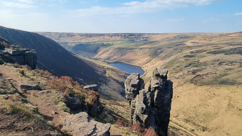
The route begins alongside the reservoirs then heads on a steep uphill to Ashway Rocks, from here you follow the edge to the iconic Trinnacles – a rocky outcrop made of three pillars. This is a popular photo spot, but please read the ‘Other Information’ section which includes recent Mountain Rescue incidents from here.
Once you’ve reached The Trinnacles, it’s time to descend to Birchen Clough, a rocky route that follows the Clough back downhill. Once you’ve reached the bottom and crossed over then it’s back via wide tracks alongside the reservoir and back to the car park.
Please note this walk is marked as a ‘stile-free walk’, however, there are stiles. Two stone ones can be avoided and the third is dog-friendly so you’d still be able to do this route with a dog. Read other information for details.
Here you will find details on how to get to the start of the walk, parking details, route information, map and GPX file, plus a detailed step by step guide of the walk.
Is this Trinnacles walk on your list to do? Let me know in the comments
Buy a printable/downloadable PDF route guide for the walk here.
Ashway Rocks + The Trinnacles walk from near Greenfield

Walk information + GPX
Walk type: Short circular walk (challenging route in places – see other information)
Distance: 4.5 miles/7.2 km
Walk time: 2-3 hours
Total ascent: 336 m/1,102 ft
Highest point: 463 m/1,519 ft
Walk highlights: Views of Dovestone Reservoir, The Raven Stones aka The Trinnacles + Birchen Clough waterfall
Trigs: 0
Ethels: 0
Stiles: 3 stiles – (see other information for details)
Ashway Rocks + The Trinnacles walk map

© Crown copyright and database rights (2024) OS 002572460
Click for OS online mapWalk start point
Start grid reference: SE 01773 04466
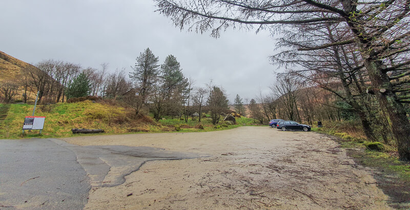
Car parking address: Binn Green car park, off Holmfirth Road, Oldham, OL3 7NN – Google location
This is a small free car park on the A 635, it gets busy at weekends, there are a couple of road laybys but please make sure you’re not on the verges or double yellow lines as you will receive a parking ticket.
There is a second car park at Dove Stone Reservoir, Greenfield which is a paid car park. This will add approximately 1.5 miles/2.5 km to your walk so please factor this into your planning.
Public transport
Unfortunately, there are no suitable public transport options for this walk. From Manchester, it’s approximately 15 miles/45 minutes taxi drive.
Facilities on the walk
Unfortunately, the public toilets are now permanently closed at Binn Green car park, due to vandalism. There are no other facilities on the walk. The nearest ones are at Dovestone Reservoir car park.
Water on your walk – I recommend a filter water bottle for your Peak District walks, it saves you from carrying extra weight and you can fill up safely and drink water from the streams on your walk.
Other useful information
Stiles on the walk – There’s one stone stile at the start of the walk, which you’ll also need to go over on your return to the car park. There is an option to avoid this, details in stage one instructions. The second stile on the walk is a wooden stile but it is dog friendly.

After heavy rain, you might not be able to cross Birchen Clough due to torrents of water coming down. Please consider the safest option on your hike may be returning via the same route.
The section down Birchen Clough has a few scramble sections as you make your way down, where you may need to use your hands on the rocks as you descend. There’s one challenging rocky scramble which is a short steep descent, if you’re not confident on this terrain please consider returning back the same way. (Photo below – looking back up at the scramble)

Important note regarding ‘The Trinnacles’ – You might have seen photos of people climbing these, it’s a sheer drop on the other side so please be careful. There have been serious incidents here where people have fallen and been seriously injured as a result. Also, consider the weather conditions, climbing in wet or windy weather can be very dangerous and increase the chance accidents. Think before you climb – Oldham Mountain Rescue.
Peak District weather
The weather can vary widely from the car park to the edge around the reservoir so please check the conditions and make sure you have warm clothes and/or waterproofs.
- BBC Weather for Greenfield
- Met Office weather for Alphin Pike (highest point nearby)
- Met Office weather and/or MWIS (Mountain weather information service) for the Peak District
Ordnance Survey walk map
The map for this walk is the Ordnance Survey OL1 – Peak District (Dark Peak Area).
View the different prices here with Ordnance Survey or Amazon. If you’re hiking in all weather the Active OS maps are good to have as they are laminated so better on rainy days.
View both Peak District map options here.
And don’t forget your compass, I recommend the Silva Expedition or the Silva Classic compass.
For online maps, I recommend OS Online App (I have been using it for many years and it is worth getting if you want to start walking more). Check prices here for the one-month or annual option with OS Online App. All the walks on the website are created using OS Online + you can download them to the App.
See both maps that cover the Peak District here.
Want to learn more map skills? Check out our Guided Walks with map reading skills here.
Win Hill patch
A stunning view from Win Hill summit complete with trig point, looking towards the Derwent Valley and Ladybower Reservoir. Have you climbed this hill? Treat yourself to the patch! Or if you are planning on doing the Win Hill walk soon, order a patch so you can take it to the top for a photo. visit shop
Charity Patches
Ashway Rocks + The Trinnacles walk route
Stage 1 – Binn Green car park to Ashway Rocks
Distance: 1.2 miles/2 km
Grid reference SE 1773 4466
From the lower car park, take the path signposted ‘To Reservoir & trails’. Go down the steps and through the narrow stone stile* and gate. Turn left onto the road. Walk down and go through the wooden gate towards the reservoir.

At the reservoir dam, turn right and walk across, follow the track as it bends around to the right then go through the wooden gate next to the cattle grid.
Immediately after this you’ll see the wide path on the left heading uphill (photo below). It’s a steep hike up towards Ashway Rocks, which you can see on your left as you walk up. As you head up the path splits in a couple of places, keep right for a more gradual ascent or take the left-hand path for a short steep push to the top.
*Avoid the stone stile – you may wish to walk down the steps first to see if you can get over, but if not then turn left down the road then the next left which will avoid the stiles. Remember to do at the end of the walk too.

Stage 2 – Ashway Rocks to The Trinnacles
Distance: 0.6 mile/0.9 km
Grid reference SE 286 497
From Ashway Rocks you now keep to the path that follows the edge, it will feel like you’re heading in the wrong direction but stay on the narrow path and it will lead you around the full edge which has beautiful views down to the reservoir below.

Eventually, you’ll come to the three iconic rocks the Raven Stones, most commonly known as The Trinnacles. These jut out from the landscape making a beautiful photo with Greenfield Reservoir in the distance.
*Please note you may have seen people have photos on these rocks, but the drop the other side is severe (go check it out from the rock on the right before you consider anything adventurous). Also, consider the weather and potential additional dangers this could incur, for example, wet rocks or a windy day. Oldham Mountain Rescue team have dealt with a couple of incidents at this location.
Stage 3 – The Trinnacles to Binn Green car park
Distance: 2.7 miles/4.3 km
Grid reference SE 362 480
From the Trinnacles continue walking on the path along the edge of the moorland. Once you’ve turned the corner and began to head southeast after about 500 metres the path will begin to descend towards Birchen Clough.
Please note – if you’d rather not do the scramble down, this is the point to turnaround and return via the same route, the walk distance will be similar.

There’s a boggy section close to the water so do your best to skirt around this and then cross over the top of Birchen Clough and turn left to begin your descent via the rocky route.
The path is muddy in places and rocky in others so take your time to descend via the safest route. The toughest part of the descent is when you reach Birchen Clough waterfall, there are 3 steep rocks that take your down to the path (see details in other information). Alternatively, you can remain on the higher route which has suffered some erosion so you’ll equally need to take care via this option.

Now continue on the right-hand side of the Clough all the way to the damn, at this point there are a few good points you can cross over the Clough (in good weather), then walk across the walkway, through the gate and begin down the wide track (photo below). Follow this around the right-hand side of the reservoir, over a couple of bridges with metal handrails then you’re on the upper path around the reservoir.

This track gradually descends to meet another path, continue straight all the way to the dam, this is the point where you began your walk. Walk back up the road, through the gate and look for the wooden gate on your right. Go through here, over the stone stile and up the steps back to the car park.
Do you have any questions about this walk including the scramble section? Ask me in the comments.
Buy a printable/downloadable PDF route guide for the walk here.
Other information + walks
Longer route
Are you looking for a longer route? Why not try our Trinnacles 12-mile route, which includes Alphin Pike trig point too.
Dovestone Reservoir Walk (+ Trinnacles) | 12-Mile Route
More walks in the Peak District
Fancy trying some walks with short scramble sections in the Peak District? You might like these walks
- Crowden Clough Scramble (Via Grindslow Knoll) From Barber Booth | 6-Mile Route
- Chrome Hill + Parkhouse Hill Walk (+ Scramble) From Hollinsclough | 5-Mile Route
- Kinder Scout Walk From Hayfield (Via Red Brook Scramble) | 9-Mile Route
Or check out all our Peak District walking routes here
*Peak District Walks participates in the Amazon Services Associates Programme, as well as other affiliate programmes. If you purchase through these, Peak District Walks earn from the qualifying links. This is at no extra cost to you. Read more here.
Peak District Walks is a FREE online resource. Are you enjoying the walks? You can say thank you and buy me a coffee here. Thank you very much 🙂
Peak District charity patches
Read about the charity here.


Charity Patches

Charity Patches

Charity Patches

Charity Patches
Charity Patches

Charity Patches
Need more help planning your Peak District trip?
Join our Peak District walks Facebook page, follow us on Instagram and Twitter for inspiration.
More information on the Peak District, including transport options, where to stay, best Peak District pubs + other useful resources.
Check out the 7 YHAs in the Peak District and find the best walks direct from your accommodation.
Find out what maps you will need for your trip here.
Top tips - Read our useful guides on hiking tips here.
Guided Walks with an introduction to map reading (see dates here).
Visit our hiking recommendations page, (footwear, clothes + kit).
Or get in touch and I will help as best I can :).
Please note 'Peak District Walks' accepts no liability for any injuries or accidents resulting from walking our routes. We always recommend you wear appropriate footwear to avoid injuries and to take a paper map and compass on your walks. Read more here.
Great walk! However the gpx file for 4.5 mile route is wrong. Any chance of an update? Many thanks
Hi Thorin, ah thanks for spotting, it’s all updated with the right GPX now 🙂