This walk from the lovely town of Bakewell in the Peak District takes you to the grounds of Chatsworth House and through the unique village of Edensor, with woodland and open views along the way.
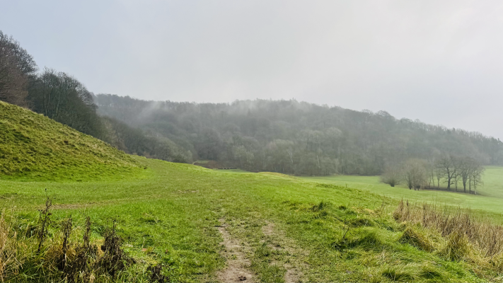
From the bustling market town of Bakewell you head up and across Bakewell Golf Course into Manners Wood, named after the powerful Manners family who once owned Haddon Hall and its estate. Emerging from the woods you cross Calton Pastures, with its historical Bronze Age Barrows. You can bag a trig point here before heading through the houses at Calton Lees.
Passing Chatsworth Garden centre you descend through a small wood to the B6012 and cross to walk alongside the River Derwent into the Chatsworth Estate. Admiring the grand views of Chatsworth House as you stroll along the river, you then curve away towards the unique estate village of Edensor.
Heading uphill again out of Edensor, you follow quiet roads until joining a bridleway down through the woods again to head back into Bakewell.
Here you will find details on how to get to the start of the walk, route information, a map, GPX file, plus detailed step-by-step directions for the walk.
Let me know in the comments if you’ve done this walk and what you think!
Buy a printable/downloadable PDF route guide for the walk here.
Chatsworth House and Edensor from Bakewell
Walk information + GPX
Walk type: Circular Walk
Distance: 7.2 miles/11.6 km
Walk time: 2.5 – 3.5 hours
Total ascent: 357 m/1171 ft
Highest point: 122 m/402 ft
Walk highlights: Manners Wood, weirs along the River Derwent, views of Chatsworth House, Edensor church and village.
Trigs: 1 – Calton Pastures (very slight diversion from footpath)
Ethels: 0
Stiles: 2
Chatsworth House and Edensor from Bakewell walk map
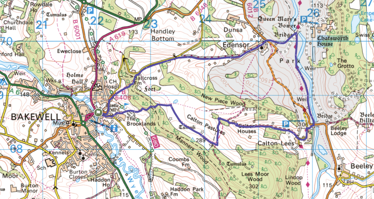
© Crown copyright and database rights (2024) OS 002572460
Click for online mapWalk start point
Start grid reference: SK 2203 6866
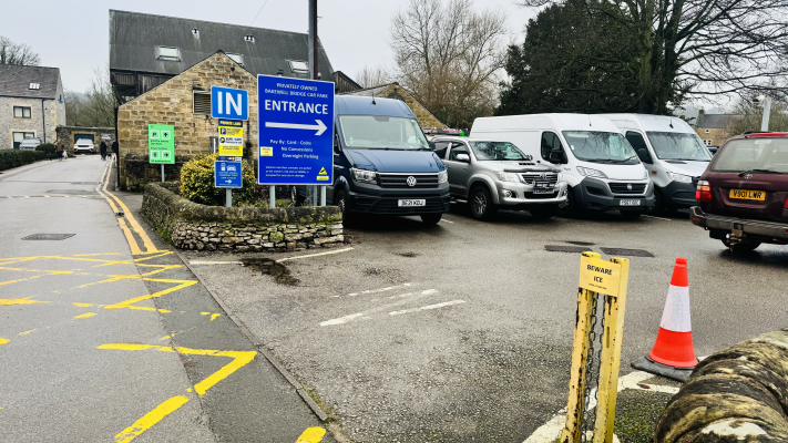
Car parking address: Bakewell Bridge Car Park, Coombs Rd, Bakewell DE45 1AQ. Google Map Location.
Bakewell Bridge is a family run, paid car park that is just a short walk over the bridge from the town centre. The carpark has over 150 spaces, with attendants to help with parking and keep vehicles secure.
Pay for your parking before leaving (prices as of December 2025):
- Up to 2 hrs – £3
- Up to 3 hrs – £4
- Up to 4 hrs – £5
- All day parking – £6
Public transport
This is an ideal walk to access via public transport as Bakewell has a good bus service from Derby, Sheffield, Matlock and Buxton, among other places. The nearest bus stop to the walk start is Rutland Square. You can find details of the various services and stops here.
Nearest train station: Matlock train station (9 miles/14.5 km)
Facilities on the walk
There are no public toilets on the walk but Bakewell town has public toilets and a wide range of cafes and pubs. Around halfway through the walk you pass Chatsworth Garden Centre which has a restaurant and toilets.
Water on your walk – I recommend a filter water bottle for your Peak District walks, it saves you from carrying extra weight and you can fill up safely and drink water from the streams on your walk.
Other useful information
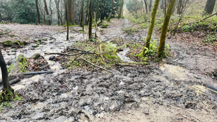
Some sections of this walk can be very muddy, especially through the woods after a lot of rain. Make sure you’ve got good walking footwear for this.
Bakewell is the largest settlement and only town in the Peak District. It is home to the delicious Bakewell Tart and is well worth an hour or two spent exploring its shops and other facilities after your walk.
Chatsworth Park is home to both Red Deer and Fallow Deer as well as plenty of sheep grazing. Chatsworth Park request all dogs need to be on a lead.
Please keep the Peak District beautiful and respect everyone who uses the park. Take ALL your rubbish home to dispose of and remember close gates (as you found them). Thank you so much.
Would you know what to do in an emergency situation?

We have a guide with what to do, who you need to call and also some useful kit that should be in your backpack. Ask us any questions in the comments or via our social media.
Happy hiking + stay safe
read herePeak District weather
Check the weather for your walk location and hills. We’d recommend that you check a few resources and for hill walks look at the weather conditions in the valley and on the hilltop as they can greatly vary.
- BBC Weather for Bakewell
- Met Office weather for Bakewell
- Met Office weather and/or MWIS (Mountain weather information service) for the Peak District
Ordnance Survey walk map
The map for this walk is the Ordnance Survey OL24 – Peak District (White Peak Area).
View the different prices here with Ordnance Survey or Amazon. If you’re hiking in all weather the Active OS maps are good to have as they are laminated so better on rainy days.
And don’t forget your compass, I recommend the Silva Expedition or the Silva Classic compass.
For online maps, I recommend OS Online App (I have been using it for many years and it is worth getting if you want to start walking more). Check prices here for the one-month or annual option with OS Online App. All the walks on the website are created using OS Online + you can download them to the App.
See both maps that cover the Peak District here.
Want to learn more map skills? Check out our Guided Walks with map reading skills here.
Chatsworth House and Edensor from Bakewell walk route
Stage 1 – Bakewell to Calton Pasture
Distance: 0.9 miles/1.4 km
Grid reference SK 2203 6866
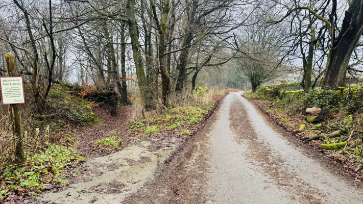
Leave the car park from the main entrance and turn right up Coombs Road. After about 300m cross to the left hand side of the road where you see a footpath sign and metal gates leading up a paved track (pic above). Follow this track, crossing the Monsal Trail after around 200m and continuing through a small wooden gate beside another metal one.
Where the paved track curves to the left you continue on the smaller path to the right, staying alongside the wall and continuing uphill to reach two more small metal gates. Once through the second of these you are crossing Bakewell Golf Club towards the woods (pic below). Be sure to watch and listen out for golfers/golf balls as you cross.
Signs on the golf course will keep you on track for the footpath and once across you enter Manners Wood. This is part of the Haddon Hall estate and can be a very muddy section. Head up through the woods for about a quarter of a mile, ignoring paths off to the left and right and crossing small streams (these may dry up in summer).
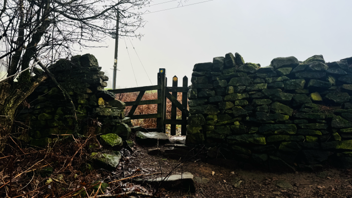
Pass a very small stone building which you’ll spot across a stream to your left and head up to a small wooden gate in the dry stone wall at the top of the woods (pic below). Pass through the gate and continue straight on Calton Pastures for around 250m, towards a small copse of trees on your left. Just past the trees you arrive at a junction of paths.
Stage 2 – Calton Pastures to Calton Lees
Distance: 1.1 mile/1.8 km
Grid reference SK 2338 6882
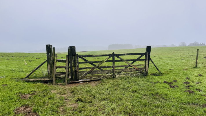
Turn right at the path junction, heading towards a fence with a metal and a wooden gate. Go through and continue in the same direction following the path across open pasture land. Just before you reach the next fence, with its wooden ladder stile (pic above), there is the chance to bag a trig point! Calton Pastures trig is just off to your right, nestled against the dry stone wall (SK 23779 68174). You can pop down and visit it before heading back to the path and continuing over the stile.
![]()
![]()
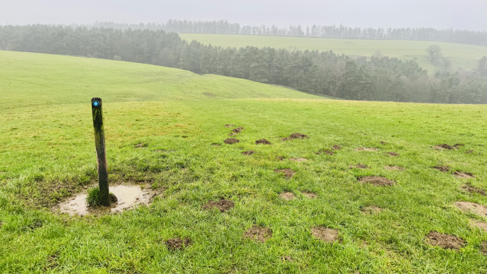
You’re now around 1.6 miles into your walk. Head towards a post in the field, with a blue bridlepath arrow (pic above). Turn left to follow this bridlepath to the trees. There are two five bar wooden gates here. Go through the right hand one (not the one leading into the woods) into the field beyond. Turn right, following the path alongside the dry stone wall, following it for around 200m to where it becomes a track, with stone walls either side, leading you through Calton Houses.
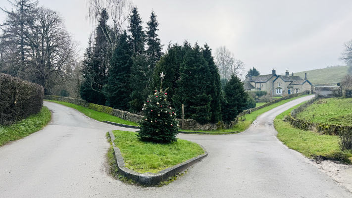
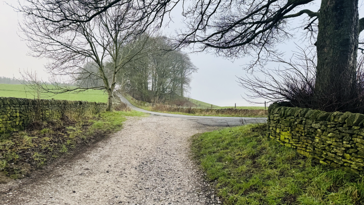
The track twists past the houses and becomes a paved single track road. Follow this for almost 1 mile to reach a junction of roads at Calton Pastures. Arriving at a small green area in front of you take the left hand fork (pic below).
Stage 3 – Calton Lees to Edensor
Distance: 2.8 miles/4.5 km
Grid reference SK 2443 6852
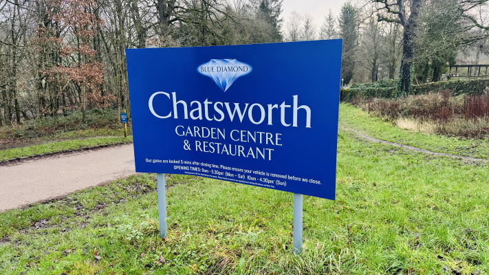
Follow the road as it curves round to the left, past Chatsworth Garden Centre and Restaurant. You’re around the halfway point in your walk and can stop at the garden centre for refreshments if needed.
Just past the garden centre, as you see the parking area on your left, look out for a small path leading down through the trees to your right. Follow this down to the B6012 road. If you miss the path you can continue along the road from the garden centre and turn right at the junction to walk down the B6012, but this is a busy section of road with no footpath.
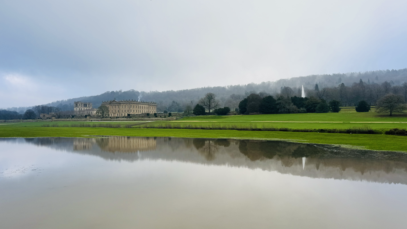
Carefully cross to the opposite side of the road, just before the bridge, and take the footpath which runs along the river towards Chatsworth House (pic above). After around 350m you pass a derelict mill building and then reach a fork in paths. Continue on the right hand path, closest to the River Derwent to admire the weirs along the way.
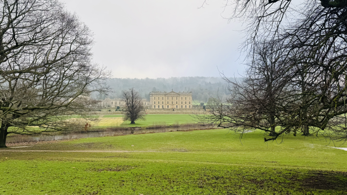
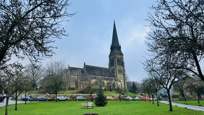
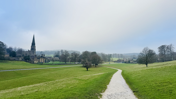
The grand facade of Chatsworth House comes into view on the opposite side of the river as you carry on for another three quarters of a mile to where the path comes up to reach a small road leading across an attractive bridge. Cross the road just before the bridge and turn left, almost back on yourself, to follow the obvious path which gradually curves around, bringing Edensor Church into view and then crossing the B6012 into Edensor.
Stage 4 – Edensor to Bakewell
Distance: 2.4 miles/3.9 km
Grid reference SK 2514 7001
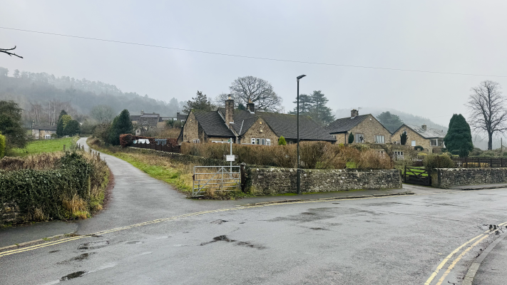
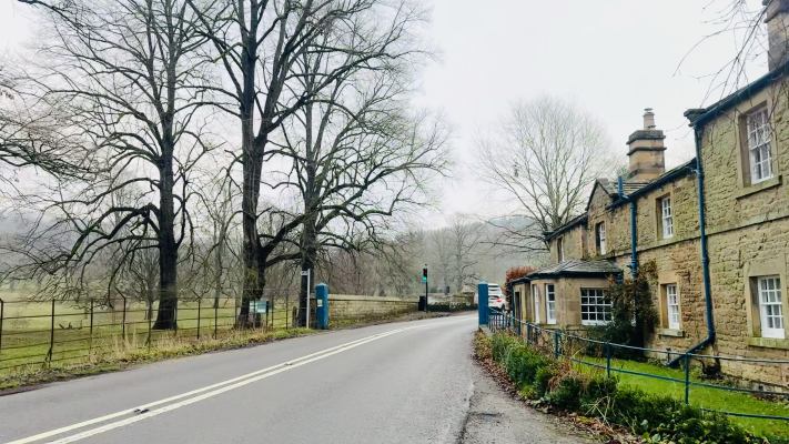
Across the B6012 you pass through a large gate, with a cattle grid to the left and gate house to the right. You are now in Edensor (pronounced Enzer) the estate village for Chatsworth. This unique village is a delight to walk through. Continue straight towards the village green and stay on this road as it leads right around the church. Passing through houses the track then continues uphill for about three quarters of a mile to reach a junction with another road (pic below).
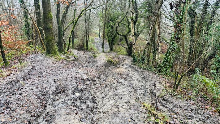
Stay left here, going straight ahead onto the larger road. Please be aware that although quiet, these are open roads. Listen out for vehicles as you walk. You are still going uphill and stay on the road for just over half a mile until, just before a right hand bend, you take a bridlepath leading into the trees to the left (pic below).
This is another section which can be very muddy as you track downhill back to Bakewell. The path winds down through the woods for around 600m – ignore paths off to the left and right.
At the bottom of the woods you emerge back onto a different section of the golf course you crossed earlier. Take care to watch out for golfers/golf balls as you follow the path down and back to meet a road. Turn left down Station Road, crossing the Monsal Trail again and heading down into the town. Reaching a junction, turn left onto Coombs Road and back to your start point.
Buy a printable/downloadable PDF route guide for the walk here.
Ask me any questions about this Peak District Walk in the comments below.
More walks around Chatsworth
Looking for other walks which take in the splendid Chatsworth House? Check out these options:
-
Chatsworth House Walk via Edensor From Baslow | 7-Mile Route
- Chatsworth Hunting Tower Walk From Baslow | 4-Mile Route
Or search all our Peak District walks here
Peak District Walks is a FREE online resource. Are you enjoying the walks? You can say thank you and buy me a coffee here. Thank you very much 🙂
Peak District charity patches
Read about the charity here.


Charity Patches

Charity Patches

Charity Patches

Charity Patches

Charity Patches

Charity Patches
Need more help planning your Peak District trip?
Join our Peak District walks Facebook page, follow us on Instagram and Twitter for inspiration.
More information on the Peak District, including transport options, where to stay, best Peak District pubs + other useful resources.
Check out the 7 YHAs in the Peak District and find the best walks direct from your accommodation.
Find out what maps you will need for your trip here.
Top tips - Read our useful guides on hiking tips here.
Guided Walks with an introduction to map reading (see dates here).
Visit our hiking recommendations page, (footwear, clothes + kit).
Or get in touch and I will help as best I can :).
Please note 'Peak District Walks' accepts no liability for any injuries or accidents resulting from walking our routes. We always recommend you wear appropriate footwear to avoid injuries and to take a paper map and compass on your walks. Read more here.
*Peak District Walks participates in the Amazon Services Associates Programme, as well as other affiliate programmes. If you purchase through these, Peak District Walks earn from the qualifying links. This is at no extra cost to you. Read more here.