
A picturesque walk through the Derbyshire Dale of Dovedale, with a detour hiking up to the top of Thorpe Cloud where you have lovely views down the dale then along the Tissington Trail to complete the route.
From Thorpe, you set off for Thorpe Cloud (see our patch here), a lovely little hill with stunning views, then it’s back down and along Dovedale, via Lover’s Leap, Ilam Rock and the Dove Holes before reaching the village of Milldale. You can stop by the river for a break here and maybe visit the takeaway cafe.
Now it’s uphill and along past Shining Tor before reaching the Tissington Trail, the final section of this walk. It is the easiest part as you follow the trail all the way back to Thorpe, passing under various bridges and another cafe at Tissington on the way. A good end to the walk, as you don’t need to worry too much about navigating!
There is also the option to start this walk from Milldale, Alsop Station or Tissington, (see start point information below).
Here you will find details on how to get to the start of the walk at Thorpe, route information, map, GPX file, plus a detailed step by step guide of the walk.
Let me know in the comments if you’ve done this walk and what you think!
Thorpe Cloud, Dovedale + Tissington Trail from Thorpe

Walk information + GPX
Walk type: Medium circular walk
Distance: 10 miles/16.1 km
Walk time: 5-6 hours
Total ascent: 414 m/1358 ft
Highest point: 284 m/932 ft
Walk highlights: Thorpe Cloud, Dovedale stepping stones, Milldale village
Trigs: 0
Ethels: 1 – Thorpe Cloud
Stiles: 3 (stone stiles, with one dog-friendly wooden stile)
Thorpe Cloud, Dovedale + Tissington Trail walk map

© Crown copyright and database rights (2024) OS 002572460
Click for online mapThorpe Cloud patch
A beautiful view of Thorpe Cloud, reach the top of this hill for amazing views down the valley of Dovedale
Celebrate reaching this lovely hill in the White Peaks with our charity patch.
Or if you are planning on doing the walk soon, order the patch now so you can take it to the top for a photo.
visit shop
Charity Patches
Walk start point
Start grid reference: SK 16375 50481
Car parking address: Narlows Lane car park, Spend Lane, Thorpe, Ashbourne, DE6 2AT. This is a medium-sized, pay and display car park, next to The Old Dog pub.
There’s also a second pay and display car park further down the road – (Thorpe Station car park, off Narlows Lane, Tissington Trail, Ashbourne, DE6 2AT)
Payment is cards only. You can find details on car parking charges here for both car parks.
Alternatively, you could start from Milldale, a small car park about 300 metres from the village, or there’s pay and display car parks at Alsop Station and Tissington car park where you could begin the walk from.
Public transport – There are no suitable public transport options to this walk start point.
Facilities on the walk
There are no public toilets available at the start of the walk at Thorpe in Narlows Lane car park; however there are toilets at Milldale and Tissington.
At Milldale there’s also a small cafe, open during peak times and at Tissington there’s a cafe as well. Alternatively, at the end of the walk there’s a pub, called the Old Dog but that’s been closed for a while, check to see if it’s reopening before planning to go.
Other useful information
During the winter and wetter months the River Dove can flood in places, which also means the stepping stones are not possible to cross.
Stiles – there are three stone stiles on this walk, one has a dog-friendly wooden stile next to it for your four-legged friends!
Please keep the Peak District beautiful and respect everyone who uses the park. Take ALL your rubbish home to dispose of and remember close gates (as you found them). Thank you so much.
Would you know what to do in an emergency situation?

We have a guide with what to do, who you need to call and also some useful kit that should be in your backpack. Ask us any questions in the comments or via our social media.
Happy hiking + stay safe
read herePeak District weather
Check the weather for your walk location and hills. It’s often good to check a few resources.
- BBC Weather for Thorpe, Derbyshire
- Met Office weather for Ilam
- Met Office weather and/or MWIS (Mountain weather information service) for the Peak District
Ordnance Survey walk map
The map required for this walk is the Ordnance Survey OL24 – Peak District (White Peak Area). Check prices here with Ordnance Survey or Amazon. If you’re hiking in all weathers the Active OS maps are pretty good to have.
View both Peak District map options here.
And don’t forget your compass, I recommend the Silva Expedition or the Silva Classic compass.
For online maps, I recommend OS Online App (I have been using for 4+ years and worth getting if you want to start walking more). Check prices here for the one month or yearly option with OS Online App. All the walks on the website are created using OS Online + you can download them to the App.
See both maps that cover the Peak District here.
Thorpe Cloud, Dovedale + Tissington Trail walk route
Stage 1 – Thorpe to Dovedale
Distance: 1.8 miles/2.9 km
Grid reference SK 16375 50481
Turn right out of the car park, go across the road and walk past the pub on your left. Walk down the road, in the distance you’ll see Thorpe Cloud ahead. As the road bends to the left, you’ll join the footpath on the opposite side of the road. There’s a small wall with stone stile signposted with green arrow markers across the grass.

Walk across the field through a second gate then over a stone step stile with a National Trust signpost for Thorpe Pastures and Dovedale pointing left (photo above). Begin walking next to the wall then head directly for Thorpe Cloud, there’s a wall with a gate at the base, go through and head up the hill.
Thorpe Cloud is made from limestone rocks, these can be very slippy in wet weather so please take care on both the ascent and descent. You’ll need to head back down in the same direction, bearing left towards the end and walk towards the wall which brings you out on to Lin Dale, with the boundary wall on your left, walk until you reach a gate which will bring you out at Dovedale stepping stones.

Stage 2 – Dovedale to Milldale
Distance: 2.5 mile/4.1 km
Grid reference SK 1514 5139
As you reach the River Dove, the route goes left through the gate, signposted Milldale; however depending on how busy it is you may wish to explore Dovedale stepping stones.
Please note – in winter the stepping stones can become flood with high water levels.

Continue following the River Dove, after about 1 km it goes up some steps to ‘Lover’s Leap’ then back down the other side. Go through another gate and continue past the Tissington Rocks and the limestone cliffs that surround Dovedale.
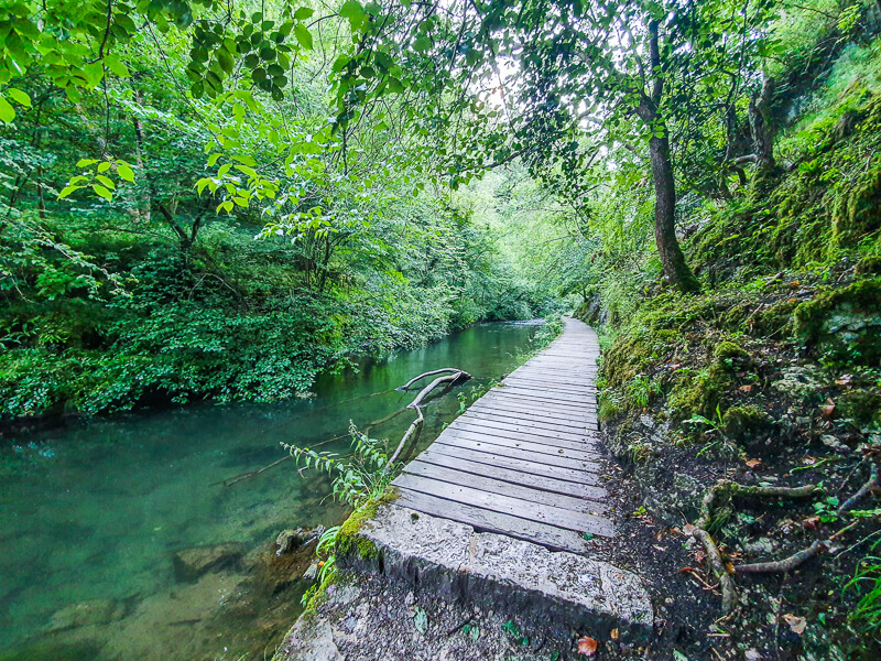
Reach a boarded section next to the river and go through another gate. Keep walking until you reach Ilam Rock on your right and a footbridge with a signpost pointing towards Stanshope.
Detour option – After about 1 km, look out for an uphill path with a large boulder a short way up, as you walk up you can see an archway, and beyond that is Reynard’s Cave. It’s fun to explore the cave but if it’s wet then the path up and down can be slippy.
From the cave keep walking along the path following the river, you’ll go past a huge cave called Dove Holes and shortly after you’ll reach the village of Milldale.
Optional – go across the bridge and stop off at Milldale for the takeaway cafe and toilets.

Stage 3 – Milldale to Tissington Trail
Distance: 1.4 miles/2.2 km
Grid reference SK 1395 5463
Before the bridge, at Milldale there’s a footpath heading uphill on your right, take this route up, the footpath switches backwards and forwards so it’s not as steep as it looks. The path then splits, take the left-hand route heading towards the wall.

Go over the stone stile, (wooden dog-friendly option) and follow the higher path alongside the wall, you’ll go past a grassy outcrop called Shining Tor which has stunning views in both directions then go through a small wooden gate signposted Alsop Station 1/2 mile. Walk along the grassy path as it bears to the left then heads straight for the road though a gate.

Turn right and walk down the road, look for a small wooden gate in the wall on your left, go through and walk across the field towards the road, though a narrow gap in the wall.
This is a busy A-road so take your time to cross, then walk up into Alsop Station car park.

Stage 4 – Tissington Trail to Thorpe
Distance: 4.2 miles/6.7 km
Grid reference x
On your left, you’ll be able to join the Tissington Trail, turn right and begin walking down the trail. You’re on the Tissington Trail for a while now, handy as you don’t need to navigate much for this part of the walk.

After about 4.2 km, you’ll reach Tissington car park where there’s a cafe and toilet for a quick stop. Then it’s another 2.5 km to Thorpe car park, turn right, walk up the road and before you know you’re back at Narlows car park.
Ask me questions about this route from Thorpe in the comments below.
More walks in the Peak District
Love the walks in the Peak District? You might like these 10-mile walks.
- The Roaches, Hen Cloud + Lud’s Church Walk From Upper Hulme
- Alport Castles Walk From Ladybower Reservoir (Fairholmes)
- Stanton Moor Plantations + Oaker Hill Trig Walk from Birchover
Or check out all our Peak District walking routes here
Peak District Walks is a FREE online resource. Are you enjoying the walks? You can say thank you and buy me a coffee here. Thank you very much 🙂
Peak District charity patches
Read about the charity here.


Charity Patches

Charity Patches
Charity Patches

Charity Patches

Charity Patches

Charity Patches
Need more help planning your Peak District trip?
Join our Peak District walks Facebook page, follow us on Instagram and Twitter for inspiration.
More information on the Peak District, including transport options, where to stay, best Peak District pubs + other useful resources.
Check out the 7 YHAs in the Peak District and find the best walks direct from your accommodation.
Find out what maps you will need for your trip here.
Top tips - Read our useful guides on hiking tips here.
Guided Walks with an introduction to map reading (see dates here).
Visit our hiking recommendations page, (footwear, clothes + kit).
Or get in touch and I will help as best I can :).
Please note 'Peak District Walks' accepts no liability for any injuries or accidents resulting from walking our routes. We always recommend you wear appropriate footwear to avoid injuries and to take a paper map and compass on your walks. Read more here.
*Peak District Walks participates in the Amazon Services Associates Programme, as well as other affiliate programmes. If you purchase through these, Peak District Walks earn from the qualifying links. This is at no extra cost to you. Read more here.