
A fabulous 10-mile route with a mix of everything for you to enjoy on a walk, the history of Eyam, a bonus trig point and Ethel plus scenic river and woodlands.
From Eyam village in Derbyshire, also known as the ‘Plague Village’, this 10-mile route begins. The village has plenty of fascinating history to immerse yourself in so you can either take your time at the start of the walk or spend some time exploring when you finish.
The walk takes you up to the highest point, Sir William Hill trig point, with fab views and another trig ticked off if you’re doing our Trig Challenge and it’s also on the Ethels List too. Head across Eyam Moor before descending through woodlands before reaching The Plough Inn pub at Hathersage.
The next part of the walk is slightly easier to navigate as you’re following the River Derwent via the Derwent Valley Heritage Trail which is signposted with purple and yellow waymarkers. Lastly, the route heads back through Stoney Middleton, then back into Eyam where you can take your pick on how to relax at the end of the route!
Here you will find details on how to get to the start of the walk in Eyam, route information, parking options, a map, a GPX file, plus a detailed step-by-step guide of the walk.
Let me know in the comments if you’ve done this walk from Eyam and what you think!
Sir William Hill + River Derwent from Eyam

Walk information + GPX
Walk type: Medium circular walk
Distance: 10.4 miles/16.8 km
Walk time: 4-5 hours
Total ascent: 471 m/1,545 ft
Highest point: 422 m/1,384 ft
Walk highlights: Eyam village (the Plague village), Sir William Hill, Views across Eyam Moor, River Derwent
Trigs: 1 – Sir William Hill
Ethels: 1 – Sir William Hill
Stiles: 5
Eyam + Sir William Hill walk map
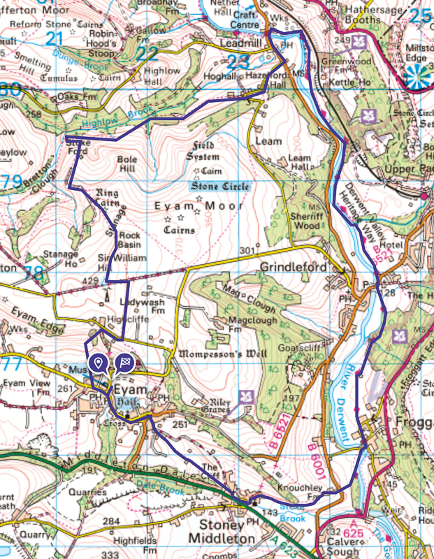
© Crown copyright and database rights (2024) OS 002572460
Walk start point
Start grid reference: SK 21619 76733
Car parking address: Eyam car park, (opposite Eyam Museum), Hawkhill Road, Eyam, Hope Valley, S32 5QP – Google location
There are two car parks at this location, the pay and display car park pictured below but if you follow the signs for a Free car park there’s a second car park directly behind it (to the right of this photo)
Parking costs (8 am to 6 pm) – Coins only
- Up to 1 hour – £1.50
- Up to 2 hours – £2.50
- Up to 3 hours – £3.80
- Up to 4 hours – £5.00
- All day – £6.00
Evening parking (6 pm to 8 am) is £1.00

Public transport
Nearest train station: Hathersage or Grindleford train station
Both Hathersage and Grindleford train station are NOT at or near the start of the walk in Eyam but you can join the route along the River Derwent. From Hathersage, it’s about 500 m or Grindleford it’s about 1 km extra on the walk so you’d need to pick up the route instructions from Stage 2 or 3 of the walk.
Alternatively, there is the 257 bus service that goes to Eyam – run by Hulleys of Baslow from Sheffield or Bakewell.
Facilities on the walk
There are public toilets available at the start of the walk at Eyam car park. There are no other toilets on the route (unless you stop at the pub at the halfway point in Hathersage)
In Eyam, there are plenty of places for food and drink, there’s Eyam Hall, The Miner’s Arms pub or the Village Green cafe. On route, you also have The Plough at Hathersage (approx halfway) and towards the end, there’s The Moon Inn at Stoney Middleton as well as a fish and chip shop.

Other useful information
There are a couple of road crossings on this walk and also small sections where you walk down roads, they are quiet ones but worth taking care.
The woodland parts of the walk can be muddy after heavy rain so it’s worth wearing waterproof footwear on rainy days (or after rainy days).
Eyam Village in Derbyshire has plenty of history with its connections with The Plague, with this in mind it can be a popular place to visit, so worth arriving early to guarantee parking. Why not visit the Eyam Museum to learn more about the village? Children/students/seniors – £2.50. Adult – £3.50

Please keep the Peak District beautiful and respect everyone who uses the park. Take ALL your rubbish home to dispose of and remember close gates (as you found them). Thank you so much.
Would you know what to do in an emergency situation?

We have a guide with what to do, who you need to call and also some useful kit that should be in your backpack. Ask us any questions in the comments or via our social media.
Happy hiking + stay safe
read herePeak District weather
Check the weather for your walk location and hills. It’s often good to check a few resources.
- BBC Weather for Eyam, Derbyshire
- Met Office weather for Eyam, Derbyshire
- Met Office weather and/or MWIS (Mountain Weather Information Service) for the Peak District
Ordnance Survey walk map
The map for this walk is the Ordnance Survey OL24 – Peak District (White Peak Area). Click to check prices here with Ordnance Survey or Amazon. If you’re hiking in all weathers the Active OS maps are pretty good to have.
View both Peak District map options here.
And don’t forget your compass, I recommend the Silva Expedition or the Silva Classic compass.
For online maps, I recommend OS Online App (I have been using it for 5+ years and worth getting if you want to start walking more). Check prices here for the one-month or yearly option with the OS Online App. All the walks on the website are created using OS Online + you can download them to the App.
See both maps that cover the Peak District here.
Sir William Hill walk route
Stage 1 – Eyam Village to Sir William Hill (Trig)
Distance: 1.4 miles/2.3 km
Grid reference SK 21596 76722
From Eyam car park turn left back down the road, then at Main Road turn right and walk down the road, you’ll go past ‘Richard Furness House’ (green sign outside the house). Take the second small road on the right, a signposted public footpath on a fingerpost between the houses (photo below).

Walk to the end and through a small gate into a field, on the right is one of the various Plague Stones where food was placed from nearby villages.
Keep to the left of the field and walk up towards the house, you’ll go through a small gate which takes you left for a short distance before reaching another arrow post directing you right alongside the house (photo below). Go up to the gate and through into the field, head diagonally right up the field towards the wall.

Turn left at the wall and walk up the track towards another gate with a wooden gap to squeeze through! There’s also an information point about Highcliffe Mine. Then up to a small gate and through a small woodland area. Walk to the next small gate and continue to another small gate, which brings you out to a wide track.

Turn left up the track for a short distance, until you reach the road. Turn right here and walk along the road for about 200 m. Look out for a stone stile on your left, with a green public footpath sign (photo above). Go over here and up the field, keeping to the right, next to the wall.
At the top it’s over another stone stile, to a track, and almost immediately go over another one opposite. Take the faint path on your left heading up towards Sir William Hill Trig point (on a good day you’ll be able to see it!)

Stage 2 – Sir William Hill to The Plough pub, Hathersage
Distance: 3.1 mile/5 km
Grid reference SK 21552 77898
From Sir William Hill trig, now head in a northerly direction away from the trig, across Eyam Moor, on the faint path which skirts alongside the edge. Keep following this for about 500 m until you reach a stone cairn, turn left here now heading downhill. (If you miss this turning and reach the wall don’t worry you can head down this way too).

As you head down you’ll go past (the back of) a green public footpath sign. You’re heading down to Stoke Ford. Continue down the path, there’s a stone stile next to a gate, go over here and continue on the grassy path. There’s another stone stile before the track narrows and bends round to the left where you’ll reach a brook.
Don’t cross the bridge, but instead take the footpath on the right heading alongside the brook, signposted Hazelford. Walk along here through a gate and over a stile until you reach a small wooden bridge (photo below), go across then over the stone stile (only go across one bridge!)

The path then leads you to a muddy section of the walk in between trees. There are a few pieces of wood/stones you can use but after heavy rain, you’ll get muddy!
As you reach the end of the track there’s a gate to go through, across the grass in between stone gate posts (no gate) then a second set of stone gate posts where the gate has been tied open (photo below).

Walk along and through the next gate, down a grassy track to another gate then you’ll come out on a quiet road. Turn right here along the road to the main road. Turn left here and you’ll see The Plough Inn on the opposite side of the road.
Stage 3 – The Plough, Hathersage to River Derwent, nr Froggatt
Distance: 3.7 miles/6 km
Grid reference SK 23422 80438
You’ll need to cross the road near The Plough Inn and head across the Leadmill Bridge over the River Derwent. Look for a turn on the right, signposted Grindleford and also a small purple/yellow sign (photo below) as you’re now picking up the Derwent Valley Heritage Trail.

Walk down here and across a cattle grid then past two stone walls and a sign for Harper Lees. After this bear right and through a kissing gate leading to a field. Keep to the left as you walk across then you’ll be back alongside the river towards the end.

After about 1 km, you’ll go through a gate into Coppice Wood, perfect for some shade, you’ll reach a fork (the left-hand one leads to Grindleford which you can take if you started the walk from the train station). You need to take the right-hand path, continuing on the Derwent Valley Heritage Trail. A small gate leads out of the woods into a field.
Keep following the path alongside the river. You’ll walk in between a stone pillar and gate until you see a random stile with no fence then a second smaller gate. Go through here and across the bridge.
Once across the bridge, turn right and go around the edge of the field to the corner then follow the river. The path then brings you out at a road, turn right and take the second turn on your left through the gate down the public footpath signposted to Curbar and Froggatt (photo below) (before you cross the river).

Walk toward the trees, following the Derwent Heritage Way signs, the path goes past a huge oak tree next to a small stream then continues heading up a track to a small gate. Go through then on to Horse Hay Coppice through a stone gap. Follow the footpath as it winds through the coppice and over another small stream.
You’ll leave the coppice through another stone gap then follow the stone path across the grass and wall. Walk along then bear right towards the corner of the wall on your right. Here you’ll see a small post with an arrow signpost. Follow the path next to the wall then through a gate to a narrow path between two walls.
Walk down here, where it turns into a road and a few houses towards the end, known as Spooner Lane.
Stage 4 – River Derwent to Eyam
Distance: 2.2 miles/3.6 km
Grid reference SK 24395 76101
After the houses, turn right across the road bridge, then take the footpath on the left signposted New Bridge and Calver. Walk along and through two small gates. After the second you’ll leave the river path and head diagonally up the field to the far left-hand corner where there’s a gap. Go through and turn right following the path up the field, keeping to the right.
You’ll go through a small gate, cross the B road and head up the smaller road opposite. You’ll walk past some farm buildings then in between the last one you’ll turn left across to a wide gate into a field.

Turn right across the field to the next gate with a stone stile next to it. Follow the narrow footpath as it heads downhill and brings you out at a small gate.
Walk across to the trees and through a small kissing gate then along the path until it brings you out to a road. Turn left, past the church. Next, take the road on the right between the houses in Stoney Middleton.
Optional (don’t take the road on the right and go straight on to The Moon Inn pub then turn right to the fish and chip shop).
As you walk down the road, take the road signposted Byway to all traffic to Eyam 1 on your right. If you did a mini detour you’ll need to do a mini circular loop to here.

Walk down Cliff Bottom, leading to Mill Lane (photo above). Follow the track, past the sign that says ‘Unsuitable for motor vehicles’. Go down this track and take the footpath on the left that goes uphill and via the Boundary Stone, continue through the small gate down a narrow track, through a gap and then two wide gates.
On your left, you’ll then see the Lydgate Graves, before the main road in Eyam village. Turn left, cross the road and walk past the Miners Arms, then the church on your right and the next right turn takes you back to Eyam car park.

Ask me questions about this Eyam walk in the comments below.
More walk options
More walks in the Peak District
Love 10-mile walks in the Peak District? You might like these circular walks.
- Mam Tor Via Jacob’s Ladder Walk From Edale | 10-Mile Ro
- Alport Castles Walk From Ladybower Reservoir (Fairholmes) | 10-Mile Route
- Stanton Moor Plantations + Oaker Hill Trig Walk from Birchover | 10-Mile Route
Or check out all our Peak District walking routes here
Peak District Walks is a FREE online resource. Are you enjoying the walks? You can say thank you and buy me a coffee here. Thank you very much 🙂
Peak District charity patches
Read about the charity here.


Charity Patches

Charity Patches

Charity Patches

Charity Patches

Charity Patches

Charity Patches
Need more help planning your Peak District trip?
Join our Peak District walks Facebook page, follow us on Instagram and Twitter for inspiration.
More information on the Peak District, including transport options, where to stay, best Peak District pubs + other useful resources.
Check out the 7 YHAs in the Peak District and find the best walks direct from your accommodation.
Find out what maps you will need for your trip here.
Top tips - Read our useful guides on hiking tips here.
Guided Walks with an introduction to map reading (see dates here).
Visit our hiking recommendations page, (footwear, clothes + kit).
Or get in touch and I will help as best I can :).
Please note 'Peak District Walks' accepts no liability for any injuries or accidents resulting from walking our routes. We always recommend you wear appropriate footwear to avoid injuries and to take a paper map and compass on your walks. Read more here.
*Peak District Walks participates in the Amazon Services Associates Programme, as well as other affiliate programmes. If you purchase through these, Peak District Walks earn from the qualifying links. This is at no extra cost to you. Read more here.
Another fab 10-miler Becky. Thank you!
Wonderful, glad you enjoyed, thanks David 🙂
This was a beautiful walk from start to finish (maybe add some time to the route for stopping to admire the view!) Thank you for sharing it we thoroughly enjoyed it and can’t wait to try some more of your walks! 😊
Ah that’s lovely to hear Alice, I’m so glad you had such a lovely walk. All the routes include the walk time so you can adjust to add your own personal time for breaks/lunch stops etc or indeed more time to enjoy the views too 🙂 I’m wondering which walk you’ll pick next 🙂
Hi.. we struggled to even find the start to this walk.. turned left out of the car park and walked down to main road. Turned right but just led us to the a623… asked resident and cafe workers where Richard furness house was and they didn’t have a clue.. really annoying as I was so looking forward to doing this walk.
Hi Julie, I’m wondering if you maybe parked somewhere different at the start of the walk, as turning right onto ‘Main Road’ doesn’t take you to the A623, ‘Richard Furness House is only about 5 minutes from the car park and the picture where you turn right between the houses in under stage 1 instructions. The car park referenced in this walk is opposite Eyam Museum. I’ve re-looked at the route instructions and my photos and I can’t figure out where you went or where you started the walk. Feel free to pop me another message if I can help further. Becky 🙂
Good afternoon,
is there a possibility to print this guide out?
many thanks kev
Hi,
We have just completed this walk & thoroughly enjoyed most of it. The only word of warning for anyone considering the route around this time of year (March 2024) is that quite a lot of the route was very very wet & muddy. Almost impassable in places without being ankle deep in mud. This has been an exceptionally wet couple of months so, hopefully, it will dry out over the next few weeks. We will definitely give it another try – after a prolonged dry spell!
Thanks for a great route. I love the way you combine descriptions with pictures and the all important map so I can keep track of where I am on OS maps. I only did the Eyam to Hathersage section which was far enough for me. Oh and that muddy section – it’s April 2025 and we’ve had a long dry spell, but there were still some very muddy patches!
Hi Julia, ah it’s lovely to hear from you and I’m glad you had a lovely day out. Yes, some of those sections in the shade don’t seem to ever dry up! Happy hiking 🙂
Lovely walk on a lovely day in the peaks. The muddy sections aren’t muddy anymore!
Ah that’s fantastic to hear. Those muddy sections will be back!! 🙂