This route starts from the historic market town of Wirksworth, with its impressive stone buildings, narrow, steep streets and enticing shops and cafes. Passing through Bolehill village you continue up to the high point of your walk at Bolehill trig point. Enter the woods beyond Bolehill, where you’ll see evidence of past quarrying, as well as a large millstone.
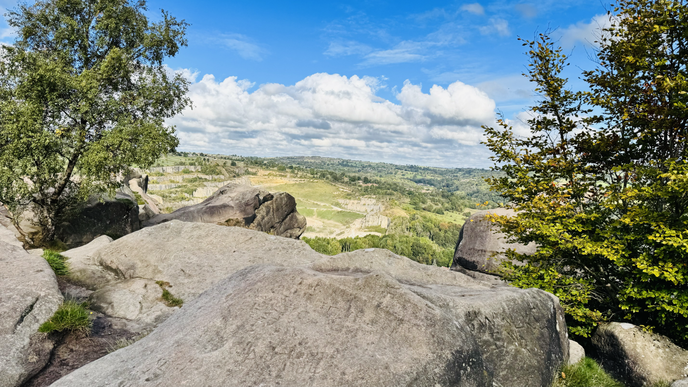
As you begin to drop down out of the woods take time to visit another highlight of the walk; Black Rocks. This impressive gritstone outcrop is great for exploring and you can also enjoy fantastic views as you stand on the impressive boulders. You might spot some climbers heading up from below too.
From Black Rocks you pass by the National Stone Centre, before heading on to the High Peak trail. This was the route of the High Peak Railway, which opened in 1831 and carried goods between the Cromford and Peak Forest Canals. Enjoy the historic features of the trail before beginning your journey back down to Wirksworth. Just before getting back to the village you enjoy the final feature of the StarDisc. This illuminated 21st century stone circle, carved into black granite, is a star chart that mirrors the northern hemisphere’s night sky.
Here you will find details on how to get to the start of the walk, route information, a map, GPX file, plus detailed step-by-step directions for the walk.
Let me know in the comments if you’ve done this walk and what you think!
Buy a printable/downloadable PDF route guide for the walk here.
Black Rocks and StarDisc from Wirksworth

Walk information + GPX
Walk type: Circular Walk
Distance: 4.4 miles/7 km
Walk time: 2 – 3 hours
Total ascent: 272 m/893 ft
Highest point: 320 m/1048 ft
Walk highlights: Wirksworth village, Bolehill trig, views from Black Rock, National Stone Centre and quarries, the StarDisc.
Trigs: 1 (but not included in trig point challenge)
Ethels: 0
Stiles: 3
Black Rocks and StarDisc walk map

© Crown copyright and database rights (2024) OS 002572460
Click for online mapWalk start point

Start grid reference: SK 2862 5395
Car parking address: The Marketplace, 11 West End, Wirksworth, DE4 4ET. Google Location.
There is alternative parking close by at Barmote Croft Car Park, 1 Chapel Ln, Wirksworth, Matlock DE4 4FF.
These are both paid car parks with slightly different charges. The charges for The Marketplace are:
- 0 to 30 mins – Free
- 0 to 1 hours – £1.80
- 1 to 2 hours – £2.80
- 2 to 3 hours -£4.00
- 3 to 4 hours – £5.00
Public transport
Bus: The TrentBarton Sixes bus serves Wirksworth regularly throughout the day on its route between Bakewell and Derby. The Market Place stop in the village is very close to the start/finish of the walk.
Nearest train station: Cromford train station (3 miles/5 km)
Facilities on the walk
There are public toilets available in the Barmote Croft Car Park mentioned above.
Wirksworth has plenty of cafes and pubs for you to choose from before or after your walk.
Water on your walk – I recommend a filter water bottle for your Peak District walks, it saves you from carrying extra weight and you can fill up safely and drink water from the streams on your walk.
Other useful information
Black Rocks are a lot of fun to explore, but please be aware there is a long drop from the rocks onto the ground below. Be cautious when exploring and don’t go too close to the edges.
Please keep the Peak District beautiful and respect everyone who uses the park. Take ALL your rubbish home to dispose of and remember close gates (as you found them). Thank you so much.
Would you know what to do in an emergency situation?

We have a guide with what to do, who you need to call and also some useful kit that should be in your backpack. Ask us any questions in the comments or via our social media.
Happy hiking + stay safe
read herePeak District weather
Check the weather for your walk location and hills. We’d recommend that you check a few resources and for hill walks look at the weather conditions in the valley and on the hilltop as they can greatly vary.
- BBC Weather for Wirksworth
- Met Office weather for Wirksworth
- Met Office weather and/or MWIS (Mountain weather information service) for the Peak District
Ordnance Survey walk map
The map for this walk is the Ordnance Survey OL1 – Peak District (Dark Peak Area).
View the different prices here with Ordnance Survey or Amazon. If you’re hiking in all weather the Active OS maps are good to have as they are laminated so better on rainy days.
Ordnance Survey walk map
The map required for this walk is the Ordnance Survey OL24 – Peak District (White Peak Area).
Check prices here with Ordnance Survey or Amazon. If you’re hiking in all weather the Active OS maps are good to have as they are laminated so better on rainy days.
View both Peak District map options here.
And don’t forget your compass, I recommend the Silva Expedition or the Silva Classic compass.
For online maps, I recommend OS Online App (I have been using it for many years and it is worth getting if you want to start walking more). Check prices here for the one-month or annual option with OS Online App. All the walks on the website are created using OS Online + you can download them to the App.
See both maps that cover the Peak District here.
Want to learn more map skills? Check out our Guided Walks with map reading skills here.
Black Rocks and StarDisc from Wirksworth walk route
Stage 1 – Wirksworth to Bolehill
Distance: 0.8 miles/1.3 km
Grid reference SK 2862 5395

Leave the carpark onto West End and turn right toward the t-junction*. At the junction turn left onto the B5023 Harrison Drive. Continue up here for just over 300m. Here you will see Wirksworth Infant School on the right, with a small lane, Cemetery Lane, leading up beside the school. Turn right onto Cemetery Lane and follow it until it becomes a track, turning slightly to the left. Continue on the track and over the railway bridge.

Over the railway, go through the small gate and the obvious path turns briefly left, then diagonally right up a field. Continue following the path left through another small gate and then round to the left as it takes you into Bolehill. The path becomes a small road, taking you past Bolehill Snooker and Darts Club and to a crossroads.
*If you’ve parked at the alternative car park on Barmote (or popped in to visit the toilet there) you’ll exit the car park, turn right onto Coldwell Street and right again on to B5023 here.
Stage 2 – Bolehill to Black Rock
Distance: 0.6 miles/1 km
Grid reference SK 2921 5494

Ahead of you is a red telephone box and, to the right of it a sign reading ‘Weight Limit 4 tons’. In-between the two you can see the footpath you are to take, leading uphill.
Keep following the green footpath signposts as this path winds steeply upwards. It’s easy to end up on someone’s driveway if you don’t follow them! At the top of the path you emerge onto a road, following the sign for ‘Public Footpath to Black Rocks via Cromford Moor’. Turn right and walk up the road for about 150m. On the left side of the road here you’ll see the footpath leading between two stones, through a small gate and up some stone steps until you come. out into a field.

Follow the footpath up the field. You’ll see a post with a footpath sign in the middle of the field. Head towards that and keep going to a metal gate, with a stile beside it at the top.

Once over the stile the path bends round to the left, towards some trees. Head to the low stone wall and round the tumbling down stile and fence into the trees (picture above). Continue along the path through the trees, emerging to Bolehill trig point.

Take some time to enjoy the trig point before continuing on the left hand path, which leads into small trees.

A small wooden gate on your left leads you into the woods (pic above). Although it is only a small stretch through here it can be tricky underfoot, with a couple of little steep steps down and the path becoming occasionally covered in leaves (I walked this in autumn). Follow the main track through and enjoy the old, mossy stone walls and millstones.

Where the path turns to the left the trees open up and you start to head downhill for about 300m. Just before you emerge into the open area of the National Stone Centre you’ll see paths off to your right which take you up to Black Rocks. There are various routes up onto the rocks, carefully head up to explore and enjoy fantastic views over to Cromford, Matlock and beyond.
Take care on the rocks, as there are some sheer drops from the edge. Once you’ve finished exploring, head down to rejoin the path where you left it.

Stage 3 – Black Rock to Middleton Top
Distance: 1.3 miles/2 km
Grid reference SK 2940 5565
As you rejoin the path you were on you’ll see it becomes more structured, with a low wooden fence alongside it. Where you see a wooden fingerpost sign turn left onto the High Peak Trail, towards Middleton Top and the National Stone Centre.

Follow this down through a quarry. You pass the Steeple Grange Light Railway and behind some houses, before going past the National Stone Centre.
About half a mile from the last fingerpost sign you come to another and continue straight on towards Middleton Top. Walk under an impressive old railway bridge and between the craggy, high stone sides of the trail until you reach a large wooden gate, with a smaller one beside it at the top of the incline.
This is Middleton Top and here you can see further evidence of the Cromford and High Peak Railway railway which once ran along this trail.

Stage 4 – Middleton Top to Middle Peak Quarry
Distance: 0.8 miles/1.3 km
Grid reference SK 2753 5517
Pass through the gate and continue straight again, following the next fingerpost sign towards Parsley Hay and the Pennine Bridleway.
When you arrive at another wooden gate and fingerpost sign, go through and turn left. Your path can be hard to spot here. As you start down the wide track you will spot some slightly run down looking vehicles on the right. The path is behind them, going between two rocks (pic below). There is a footpath sign (towards the right of the picture) but it’s easy to miss.

Once on the path you come to a small wooden gate leading into a grassy field. Go through and cross the field. The path goes to the corner of an old stone wall and on down to pass a gap in another, tumbling down dry stone wall. Continue across the next field to an old metal gate, with another small, wooden gate beside it. Pass through and continue across another field to a stile, beside a gateway, which takes you out to the B5035.

Carefully cross the B5035 and take the footpath directly opposite you – signed with a wooden fingerpost. Continue on the path diagonally left across the field ahead to a gap in the stone wall. Pass through another field and stone wall in the same direction. After the second stone wall the path turns slightly right and crosses another grassy field to reach a kissing gate in the corner.

Stage 5 – Middle Peak Quarry to Wirksworth
Distance: 0.9 mile/1.4 km
Grid reference SK 2769 5451
Pass through the kissing gate and into Middle Peak Quarry (pic below), where you will follow an obvious, fenced track for about half a mile, before emerging through a wooden gate and down some steps onto a parking area at the top of two roads.

Take the left hand fork of the road, heading up Greenhill. Although this is a small, quiet road please be aware of traffic. After about 225 m you will see an ornate archway on your left with the words Stoney Wood on it. Go through the archway and you will find yourself at the StarDisc.

Take a little time to enjoy the StarDisc and the views surrounding it before heading back onto the road and continuing the final 500m back down into Wirksworth. Continue on Greenhill until it becomes Dale End, passing between lovely old stone buildings, before you reach your start point at the Market Place
Buy a printable/downloadable PDF route guide for the walk here.
Ask me any questions about this walk in the comments below.
More walks in the Peak District
Love the walks in this are? You might like the walks below.
Or search all our Peak District walks here
Peak District Walks is a FREE online resource. Are you enjoying the walks? You can say thank you and buy me a coffee here. Thank you very much 🙂
Peak District charity patches
Read about the charity here.


Charity Patches

Charity Patches

Charity Patches

Charity Patches

Charity Patches

Charity Patches
Need more help planning your Peak District trip?
Join our Peak District walks Facebook page, follow us on Instagram and Twitter for inspiration.
More information on the Peak District, including transport options, where to stay, best Peak District pubs + other useful resources.
Check out the 7 YHAs in the Peak District and find the best walks direct from your accommodation.
Find out what maps you will need for your trip here.
Top tips - Read our useful guides on hiking tips here.
Guided Walks with an introduction to map reading (see dates here).
Visit our hiking recommendations page, (footwear, clothes + kit).
Or get in touch and I will help as best I can :).
Please note 'Peak District Walks' accepts no liability for any injuries or accidents resulting from walking our routes. We always recommend you wear appropriate footwear to avoid injuries and to take a paper map and compass on your walks. Read more here.
*Peak District Walks participates in the Amazon Services Associates Programme, as well as other affiliate programmes. If you purchase through these, Peak District Walks earn from the qualifying links. This is at no extra cost to you. Read more here.