
A lovely route for a morning or afternoon walk from Baslow. This 7-mile walk includes two of the Peak District’s beautiful and quieter edges – Baslow Edge and Gardom’s Edge.
From the small village of Baslow the walk takes you on a circular loop beneath Baslow Edge before looping back and taking you along the top. Next it’s a short section across to the moorlands which leads to Gardom’s Edge and finally, a change of scenery as you walk through woods back to Baslow.
This is a lovely walk to do, perfect in the autumn as you can see all the beautiful colours of the trees from high above as you walk along the gritstone edges.
Here you can find all the walk information, including where to park, the route map and full directions for the walk.
Fancy a shorter or longer walk from Baslow you can find all our Baslow walks here.
Let me know in the comments if you’ve done this walk from Baslow and what you think!
Baslow Edge + Gardom’s Edge from Baslow

Walk information
Walk type: Medium circular walk
Distance: 7.2 miles/11.6 km
Walk time: 3-4 hours
Total ascent: 320 m/1,049 ft
Highest point: 315 m/1,033 ft
Walk highlights: Views of Baslow Edge from below, views towards Curbar Edge. Highland Cows, Gardom’s Edge views
Trig points: 0
Ethels: 0
Stiles: 6 (2 are optional)
Baslow Edge + Gardom’s Edge walk map

© Crown copyright and database rights 2021
Click for online map
Walk start point
Start grid reference: SK 25823 72083
Car parking address: Nether End car park, Church Lane, Baslow, DE45 1SR – Google location
This is a medium sized paid car park, peak costs (see below*) apply between 8 am to 6 pm. Evening parking is £1.20 between 6 pm and 8 am. There is a cash, card option to pay or pay by phone; however, the card option hasn’t worked each time I’ve visited, I’d recommend taking cash!
- Up to 1 hour £1.70
- Up to 2 hours £2.70
- Up to 3 hours £4.00
- Up to 4 hours £5.20
- All day £6.20
*Prices correct at time of writing.

Public transport
There’s no train station in Baslow (nearest one is Grindleford – 5 miles away) however, there are buses that stop in Baslow that go between Bakewell and Buxton. See timetable for the X70 bus service here.
Facilities on the walk
There are public toilets available at the start of the walk at Baslow; however there are no other toilets on the route.
At Curbar Gap car park, a short distance up the road from the route, there is a van called Jolly’s that sells hot drinks at weekends.
In Baslow, there are options for places to eat and drink – The Wheatsheaf (great food here), Cafe on the Green or you can pop to the nearby Robin Hood Inn (lovely food here too – you’ll need to book a table at weekends!)
Other useful information
Baslow can be a popular place to start a walk so arrive early to guarantee a space. Alternatively, there’s a car park at Curbar Gap, which is just off the route but this can be equally as busy.
The bridge at the end of the walk has been damaged by a fallen tree, it’s passable but please take care, if it has been damaged further please let me know via email or the comments.
There are a few sections of this route that can be muddy, please wear the appropriate footwear for your walk.
Please keep the Peak District beautiful and respect everyone who uses the park. Take ALL your rubbish home to dispose of and remember close gates (as you found them). Thank you so much.
Would you know what to do in an emergency situation?

We have a guide with what to do, who you need to call and also some useful kit that should be in your backpack. Ask us any questions in the comments or via our social media.
Happy hiking + stay safe
read herePeak District weather
Check the weather for your walk location. It’s often good to check a few resources. Although, not too high, Baslow Edge section can be cooler in temperature especially on windy days.
- BBC Weather for Baslow
- Met Office weather for Baslow
- Met Office weather and/or MWIS (Mountain weather information service) for the Peak District
Ordnance Survey walk map
The map required for this walk is the Ordnance Survey OL24 – Peak District (White Peak Area). Check prices here with Ordnance Survey or Amazon. If you’re hiking in all weathers the Active OS maps are pretty good to have.
View both Peak District map options here.
And don’t forget your compass, I recommend the Silva Expedition or the Silva Classic compass.
For online maps, I recommend OS Online App (I have been using for 3+ years and worth getting if you want to start walking more). Check prices here for the one month or yearly option with OS Online App. All the walks on the website are created using OS Online + you can download them to the App.
See both maps that cover the Peak District here.
Baslow Edge + Gardom’s walk route
Stage 1 – Baslow to Baslow Edge
Distance: 2 miles/3.3 km
Grid reference SK 25816 72083
From Nether End car park entrance/exit cross the side road and main road at the traffic lights, finally cross the side road heading up Eaton Hill. Walk up the road for 500 m to the house on the corner, turn right and continue up the road for 500 m. Turn left through the gap next to the metal gate onto the grass (photo below).

Walk along the grassy path, passing through a small gate then continue and climb a wooden stepped stile over the wall. From here, bear diagonally right across the field towards the wall on the edge of the field to a wider rocky track.
Along the track there’s a wide gap in the wall but keep walking and you’ll reach a small gate with a fingerpost and yellow arrow. Go through and walk along until you reach a path junction where there’s a green public footpath signpost.

From the signpost, take the upper footpath straight ahead of you, signposted ‘Bridleway Curbar Edge’, walk along here through a gap in a wall and continue along through a wooden gate. Shortly after the path splits, keep on the right-hand fork then almost immediately after you reach another path junction, this time turn right and begin to head uphill towards Baslow Edge through a narrow gap in the stone wall (photo below).

Walk up the footpath alongside the wall and you’ll go over some stone steps next to a tree and continue all the way to a small wooden gate that brings you out at the road (there’s a sign for Curbar Gap next to the gate).
There’s a narrow footpath that runs alongside the road next to the wall, follow this as the road can be busy, shortly after you’ll bear right and go through a gate.
Begin following the footpath, after 100 m the path splits, take the right-hand option which curves along the edge of Baslow Edge. Walk along here and you’ll reach a lovely viewpoint which has a small sign that shows you all the hills you can see from here.

Stage 2 – Baslow Edge to Gardom’s Edge
Distance: 2.1 mile/3.4 km
Grid reference SK 2600 7455
From this point, follow the rocky path alongside Baslow Edge, there are a couple of options as you head across so pick the route you are happiest with, you’ll walk across a grassy section then back up as the path follows Baslow Edge.
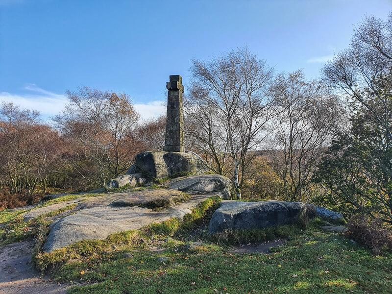
As you near the end of Baslow Edge the route curves around to the left and down to a path junction. Go straight ahead here, walking towards the large stone cross, known as Wellington’s Monument. Follow the track as it heads alongside the wall and bears round to the right. Here is where you may see some Highland Cows, either in the woods or in the field next to the path.
Continue walking along the path until you reach a gate that brings you out at the road, turn right and walk down the road until you meet a busy crossroads, take care and go across the road. On the corner of the wall there’s a gate that leads back to the open moorland.
Begin following the footpath then shortly after take the right-hand fork which heads towards the tree line along Gardom’s Edge. Follow the rough path as it heads parallel to the road, there’s a stile in the fence which you can go over to explore the rocky outcrop, then it returns (over another stile back to the path. (You can miss this section and continue alongside the fence).
Stage 3 – Gardom’s Edge to Baslow
Distance: 3 miles/4.9 km
Grid reference SK 2742 7378

Go through the wooden gate (photo above) and follow the rough path through the trees, you’ll reach a stone wall with a gap in it, go through here and keep walking along Gardom’s Edge.
Walk along the route as it heads alongside the wall, to a large stone cairn. Go through the gap in the stone wall and walk on the path heading downhill until you reach an intersecting path with a huge flat rock. Turn right here and walk down the path through the woods.
At the bottom, you’ll go over a wooden stile, then a small stone stile that meets the road. Cross the road here, turn left and walk along the pavement for 300 metres. Then go over the stone stile at the signpost for public footpath.
Walk down the footpath then over the small footbridge. Walk up alongside the boundary fence until you reach a wooden and metal gate. Turn left here through the gate and follow the path through the plantation. This section can be very muddy in places and there are a few tricky sections.
Continue until it brings you out at another path, turn right and walk down and through a small wooden gate which brings you out at some houses. Turn left at the road and walk down to the church on the corner. Turn left here and follow the road all the way back to the car park at Baslow.
Ask me questions about the Baslow Edge + Gardom’s Edge walk in the comments below.
More walk options
Longer walk
Fancy a longer walk, we have a few other walks from Baslow here:
Try our Baslow Edge + Birchen Edge Walk from Baslow, 9-mile route or another option is Baslow Walk (Including Froggatt Edge, Curbar Edge + Baslow Edge) an 11-mile route with a fantastic mix of scenery.
More walks in the Peak District
Looking for more 7-mile walks in the Peak District? How about these options…
- Alstonefield Walk (Via Milldale + Dovedale) | 7-Mile Route
- The Roaches Walk + Hen Cloud From Upper Hulme | 7-Mile Route
- Mam Tor + Lose Hill Walk From Castleton | 7-Mile Route
Or check out all our Peak District walking routes here
Peak District Walks is a FREE online resource. Are you enjoying the walks? You can say thank you and buy me a coffee here. Thank you very much 🙂
Peak District charity patches
Read about the charity here.


Charity Patches

Charity Patches

Charity Patches

Charity Patches

Charity Patches

Charity Patches
Need more help planning your Peak District trip?
Join our Peak District walks Facebook page, follow us on Instagram and Twitter for inspiration.
More information on the Peak District, including transport options, where to stay, best Peak District pubs + other useful resources.
Check out the 7 YHAs in the Peak District and find the best walks direct from your accommodation.
Find out what maps you will need for your trip here.
Top tips - Read our useful guides on hiking tips here.
Guided Walks with an introduction to map reading (see dates here).
Visit our hiking recommendations page, (footwear, clothes + kit).
Or get in touch and I will help as best I can :).
Please note 'Peak District Walks' accepts no liability for any injuries or accidents resulting from walking our routes. We always recommend you wear appropriate footwear to avoid injuries and to take a paper map and compass on your walks. Read more here.
*Peak District Walks participates in the Amazon Services Associates Programme, as well as other affiliate programmes. If you purchase through these, Peak District Walks earn from the qualifying links. This is at no extra cost to you. Read more here.
Another walk that we loved Becky – and this one had no sheep, pheasants, chickens or enticing farmyard smells to distract Dylan, our excitable spaniel . Thanks loads
Aww so glad you loved it Sarah, also thank you for the Buy me a Coffee (and cake), very kind of you and much appreciated. Hope you get to enjoy plenty more walks 🙂
Great walk! Had a mix of everything. Slightly confusing at the beginning of the walk as there’s no church at the top of Eaton Hill but otherwise good information!
Oh no, I have no clue why I typed Church instead of house! Sorry for confusing you but I’m glad you still enjoyed the walk. And I’ve updated so no more confused walkers. Oops! 🙂
Excellent instructions for a really enjoyable walk. (2nd June 2022). You are right about the bit down through the plantation towards the end, even after a dry spell there are still some muddy sections but not difficult to pass through. Thank you for providing one older walker with a lovely day, Jasper the cockapoo loved it too!
Aww how lovely, thank you for taking the time to write a message and I hope you enjoy many more walks with Jasper 🙂
Hi Becky ..the Baslow edge and Gardom’s edge from Baslow ….may I ask ..is it very steep or gentle climbs …My hubster has had 3 heart attacks in the past .plus heart bypass …we have no issue with the length of walks ..but tend to stay away from steep climbs ..although we did Win Hill last week ……of course our hilly walks over the yrs are getting more limited ….we have done the edges but not Gardoms edge ……and gentle ascents are getting hard to find …..we walk the Grindsbrook clough but stay away from the scramble ….Linear is not a problem ..help ….
Hi Margaret, the total ascent for the walk is 320 m, the ascent is throughout the distance so there’s no big steep climb but you may wish to compare this ascent to other walks you’ve done to see how it compares for you personally. I’d say hiking up Win Hill would be much steeper than this hike so if you’ve had no issue with that then this walk should be ok. I hope that helps and have a wonderful walk 🙂
Lovely walk thanks for the clear instructions! Myself and my dog thoroughly enjoyed it. Unfortunately the footbridge towards the end of the walk has collapsed with the recent rain and is not passable.
Ah thanks Jodie, those floods caused no end of damage around that area. I’m guessing you walked back via the road into Baslow. I’ll update the post as I can imagine it’ll be a while before the bridge is fixed. Thanks 🙂