
The glory of the Peak District is that you don’t have to go on an epic hike up multiple hills to enjoy its beauty. You can have a great time exploring the area on easier, shorter walks with a little less climbing too.
In this collection of our walks we’ve picked ones which are easier in terms of terrain, distance and navigation, so you can choose a walk which suits your current mood and ability. Some of these walks do still include hills, so take a look at the descriptions below and you can pick your perfect easy Peak District walk.
Let me know in the comments which of these walks you have done and what you enjoyed most!
13 Easy Walks in the Peak District
All the walks below are between 2 and 5 miles in distance. You can find a brief summary of the walk here and then click the links to find the full description, map and GPX of each walk.
If you’re just starting out with hiking, recovering from injury or simply enjoy shorter strolls you’ll find bundles of inspiration with these varied walks. You certainly won’t miss out either; we’ve made sure there are views and points of interest a-plenty for you to enjoy.
Monsal Trail walks
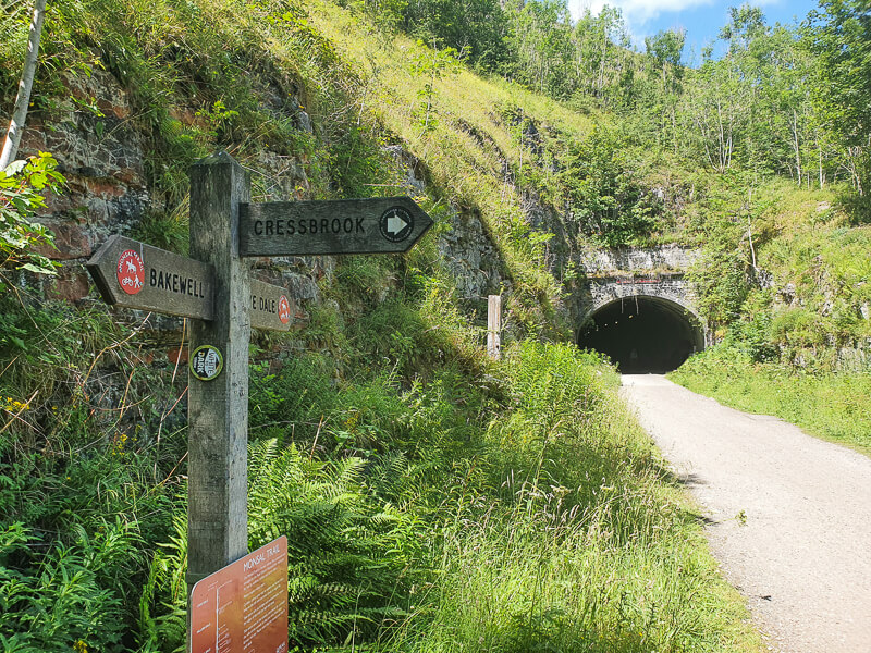
We’re starting off with a bit of a cheat here because we’ve got not one, but multiple short walks you can enjoy on the Monsal Trail. With short options from 2 to 5 miles and information about accessibility, these walks are a great starting point for anyone wanting to explore the Peak District.
The Monsal Trail itself is 8.5 miles long and is a motor-traffic free route, created from part of the former Midland Junction Railway. Due to its history as a railway line, there are lots of interesting features, such as tunnels, beautiful bridges and the former ticket station and goods shed, which is now a cafe and museum. There are lots of access points to the trail and places for cycle hire, in case anyone in your party would prefer two wheels to two feet!
Walk route, map + GPX hereMonsal Head walk

Distance: 1.5-2 miles
Time: 45mins – 1hr
Total Ascent: 126m/413ft
For a different perspective on the Monsal Trail why not try this beautiful short, circular walk from Monsal Head? Heading over Monsal Viaduct you will gain great views down into Monsal Dale and to the trail.
Having taken in some dreamy views you descend from Monsal Head to the River Wye and Monsal Weir, before walking under striking Monsal Viaduct and gradually climbing back to your start point. Did we mention there’s a pub, cafe and ice cream stand back at your start point? Perfect for post-walk refreshments!
Walk route, map + GPX hereDerwent Dam & Ladybower Reservoir from Fairholmes

Distance: 6 miles
Time: 2-3 hours
Total Ascent: 172m/564ft
A wonderful walk around part of Ladybower Reservoir from Fairholmes Visitor Centre in the Upper Derwent Valley of the Peak District. This walk is perfect for a morning or afternoon adventure, and will suit most people.
This route is low-level, with no stiles, making it ideal for almost everyone. However, there are some steps, so those in wheelchairs or with pushchairs will need to take a short detour to complete the loop. (Read the section in ‘Other Information’).
Walk route, map + GPX hereBaslow Edge from Curbar

Distance: 3.3 miles
Time: 1.5-2 hours
Total Ascent: 151m/495ft
We can’t guarantee you’ll see the Highland Cows but we can guarantee a great 3 mile circular walk. Starting from Curbar Gap Car Park, you have a short uphill section onto Baslow Edge, where you can enjoy the views over Curbar Edge and beyond.
The landscape is often bursting with colour, which changes with the seasons, and is dotted with gritstone rock formations. Heading back across the Open Access land of Big Moor, this is where you may spot deer and the above mentioned Highland Cattle!
Walk route, map + GPX hereDamflask Reservoir from Low Bradfield

Distance: 3.9 miles
Time: 1.5-2 hours
Total Ascent: 37m/121ft
This four mile walk is ideal if you’re looking for a relatively flat route, with no stiles. If you’ve got a suitable, off-road, pushchair or wheelchair, which can manage a bit of mud and some slight inclines, you’ll be able to enjoy the glorious refections on the water all the way round the reservoir.
Damflask Reservoir has a fascinating but tragic history, being named after the village of Damflask which once stood here. In 1864 a newly built dam collapsed causing the Great Sheffield Flood, which swept away the entire village. The village was never rebuilt as plans were already in place to build a reservoir here.
Walk route, map + GPX hereRowter Rocks and Stanton Moor

Distance: 4.5 miles
Time: 2-3 hours
Total Ascent: 182m/600ft
This might be a short walk but it’s certainly not short on points of interest! With names such as Nine Ladies Circle, Cork Stone and The Tower, you know you’re going to enjoy some pretty cool places, with a lot of history attached.
The walk does have a bit more climbing than the previous ones but your reward is visiting the Moor Plantations trig point on Stanton Moor and views over Robin Hood’s Stride. You can learn more about the fascinating Rowtor Rocks in the full walk description – we promise it will make you want to visit!
Walk route, map + GPX hereChatsworth Hunting Tower from Baslow

Distance: 3.8 miles
Time: 1.5-2.5 hours
Total Ascent: 229m/751ft
Make a real day of a visit to the impressive Chatsworth House with this short walk from the car park in Baslow. Chatsworth has hundreds of years of history to occupy you, both inside and out. This walk takes you to its impressive Hunting Tower, as well as the lush, wooded area around the pretty aqueduct.
This is a great walk for all weathers as the trees provide shelter from rain or sun. And, you’re never really too far from a tea room either! Enjoy your return journey along the Derwent Valley Heritage Trail.
Walk route, map + GPX hereLangsett Reservoir walk

Distance: 4 miles
Time: 1.5-2.5 hours
Total Ascent: 216m/708ft
A beautiful walk which is perfect for most walkers in most weathers! Despite staying at fairly low level you will get great views over the surrounding moorlands, as well as the reservoir itself.
Spend time in the shelter of woodlands, as well as emerging onto the open moors. Up here you may spot the ruins of North America Farm. The farm was abandoned in 1907 and the buildings used as target practise during WWII, but some stones still stand. Can you see the indentations on the stones, made by the shells hitting them?
Walk route, map + GPX hereRiver Derwent from Hathersage

Distance: 4.8 miles
Time: 2-3 hours
Total Ascent: 182m/597ft
Take a walk which is low on ascent but high on the attractiveness factor! Hathersage is a popular Peak District village, packed with outdoor shops and good pubs and cafes offering pre and post-walk shopping and refreshments.
If you do this walk be sure to take the little detour at the start, which you’ll find in the full description, for a lovely extra feature. There’s a second fun, extra feature a couple of miles in – will you cross the stepping stones just for the joy of it??
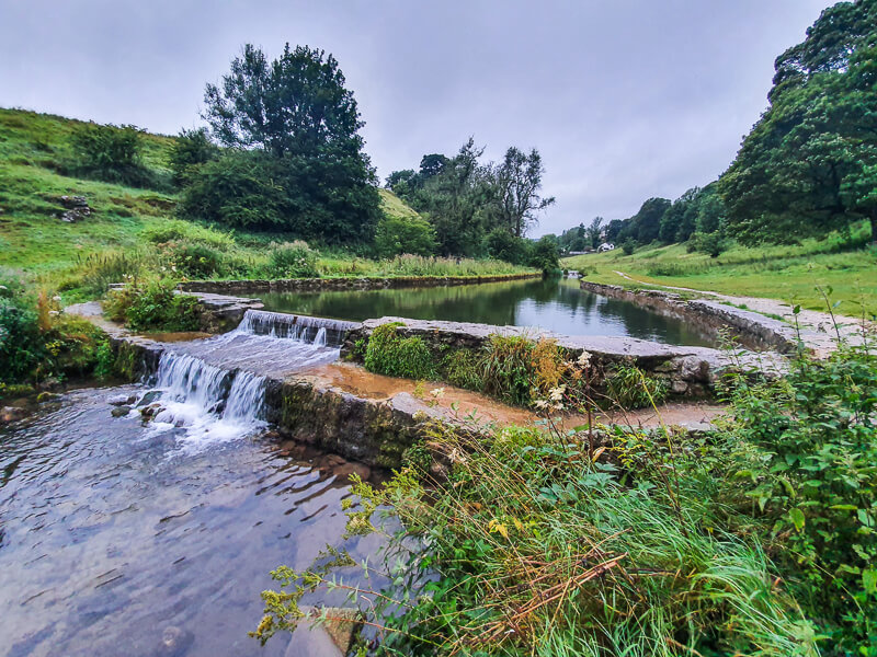
Walk route, map + GPX hereBradford Dale from Youlgreave
Distance: 4.6 miles
Time: 2-3 hours
Total Ascent: 216m/708ft
It’s hard to know when the best season is to do this walk; it’s glowing with orange and red hues in autumn, gloriously lush and green in summer, bursting into life in spring and charming on a frosty winter day! Maybe you need to do it four times through the year and let us know your favourite?
If you’re a wild swimmer this walk has the added attraction of one of the best swim spots in the Peak District. Plus, there’s a hidden secret in the wall near the River Bradford. Can you spot it?!
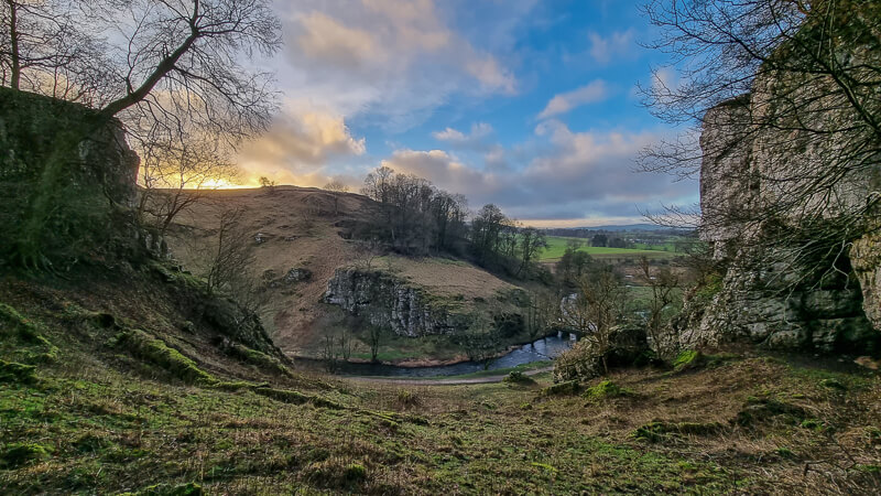
Walk route, map + GPX hereWolfscote Dale from Hartington

Distance: 5.4 miles
Time: 2.5-3 hours
Total Ascent: 262m/859ft
Although this walk is a little over 5 miles it’s reasonably gentle on the legs, with undulating terrain taking you through three of the Peak District’s pretty dales. It is also relatively easy to navigate as you wind your way along the dale footpaths and alongside the River Dove.
Enjoy rolling greenery, jutting limestone rocks and eye sparkling views over surrounding hills on this prettiest of White Peak walks. And don’t worry, it’s a long time since the last wolf was seen in Wolfscote Dale!
Walk route, map + GPX hereMam Tor from Castleton

Distance: 5 miles
Time: 2-3 hours
Total Ascent: 515m/1690ft
We couldn’t have an easy walks compilation without adding in this classic! This walk does have a bit more ascent so you might want to take your time, but the views from Mam Tor are 100% worth the effort. Those views do mean this route is a very popular one, so it’s best to do it early in the day and avoid weekends if possible.
Mam Tor is also known as the ‘Mother Hill’ and was once an Iron Age Fort. You can see why it would have been a great place to use as a lookout – there’s not much chance of sneaking up on someone with that 360 degree panorama surrounding you.
The stone pillar at the top of the hill is known as a trig point. You’ll find these dotted around the whole country and some people even like to ‘bag’, or tick off trig points as they visit them. Want to know more? Just click here!
Walk route, map + GPX hereRushup Edge from Barber Booth

Distance: 5.3 miles
Time: 2-3 hours
Total Ascent: 359m/1177ft
If you want the Mam Tor views without the Mam Tor crowds, this might just be the walk for you. From Rushup Edge you can take in the sweeping scenery of valleys on both side of you, as well as looking ahead to the tops of Mam Tor, Lose Hill and beyond.
You’ll also be bagging a Peak District Ethel on this walk. Ethel’s are high points in the Peak District and are named after Ethel Haythornthwaite. You can read more about them and our Ethel Bagging Challenge here.
Walk route, map + GPX here
Do you have any more questions about these easy walks? Ask me in the comments below.
Ordnance Survey Walk Maps
For these walks, two maps cover them OL1 – Peak District (Dark Peak Area) and OL24 – Peak District (White Peak Area)
Shop online at Ordnance Survey
And don’t forget your compass, I recommend the Silva Expedition or the Silva Classic compass.
For online maps, I recommend the OS Online App (I have been using it for many years and it is worth getting if you want to start walking more). Check prices here for the one-month or annual option with the OS Online App. All the walks on the website are created using OS Online + you can download them to the App.
Check prices here for the one month or yearly option with OS Online App.
More walks in the Peak District
Love the walks in the Peak District but want to go a little further? You might like these 7 mile Peak District walks.
Or check out all our Peak District walking routes here
*Peak District Walks participates in the Amazon Services Associates Programme, as well as other affiliate programmes. If you purchase through these, Peak District Walks earn from the qualifying links. This is at no extra cost to you. Read more here.
Peak District Walks is a FREE online resource. Are you enjoying the walks? You can say thank you and buy me a coffee here. Thank you very much 🙂
Peak District charity patches
Read about the charity here.


Charity Patches

Charity Patches

Charity Patches

Charity Patches

Charity Patches

Charity Patches
Need more help planning your Peak District trip?
Join our Peak District walks Facebook page, follow us on Instagram and Twitter for inspiration.
More information on the Peak District, including transport options, where to stay, best Peak District pubs + other useful resources.
Check out the 7 YHAs in the Peak District and find the best walks direct from your accommodation.
Find out what maps you will need for your trip here.
Top tips - Read our useful guides on hiking tips here.
Guided Walks with an introduction to map reading (see dates here).
Visit our hiking recommendations page, (footwear, clothes + kit).
Or get in touch and I will help as best I can :).
Please note 'Peak District Walks' accepts no liability for any injuries or accidents resulting from walking our routes. We always recommend you wear appropriate footwear to avoid injuries and to take a paper map and compass on your walks. Read more here.