
Chrome Hill walk is a short but steep route from Hollinsclough in the Peak District, but it’s a hike with many rewards. This circular walk starts from Hollinsclough, Staffordshire, but Chrome Hill is located in Derbyshire, so you can say you’ve walked in two counties!
On this walk, you’ll see the iconic limestone hill from different views as you begin walking with the hill on your right, as well as its neighbour, Parkhouse Hill. Then, further along, you approach the hill from the north, before finally walking across the top and down the other side. Chrome Hill is well-known as the ‘Dragon’s Back of the Peak District’- you’ll see what I mean when you do this short walk!
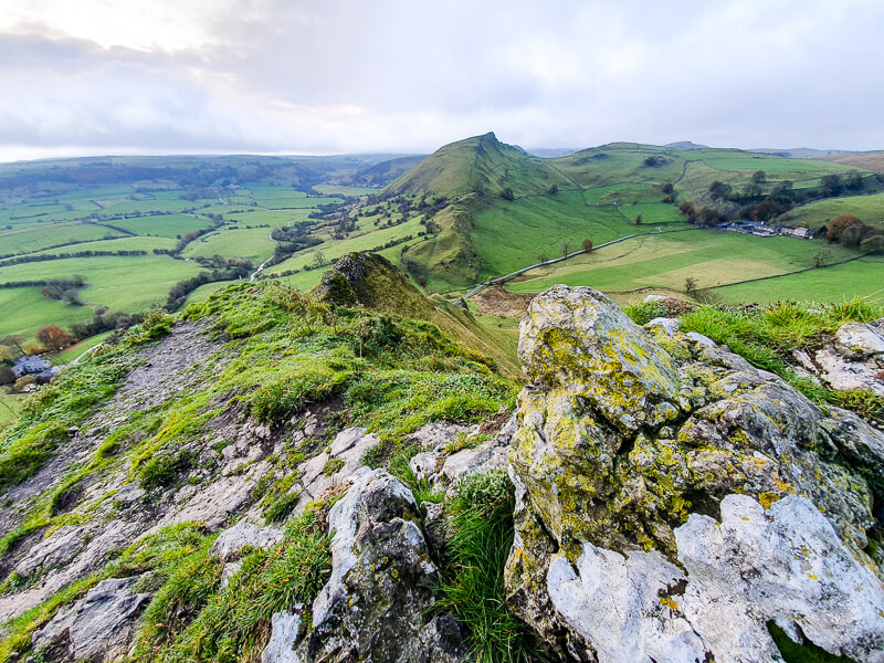
From the summit of Chrome Hill, there are beautiful views of the narrow River Dove twisting through the beautiful Upper Dove Valley of the Peak District.
Here you will find all the walk details of this 4-mile route, including how to get to the start of the walk, route information, map, GPX file, plus a detailed step-by-step guide of the walk.
There is the option to extend the walk, including hiking up Parkhouse Hill too – Read the 5-mile route here.
Let me know in the comments if you’ve done this walk and what you think!
Buy a printable/downloadable PDF route guide for the walk here.
Chrome Hill walk from Hollinsclough

Walk information + GPX
Walk type: Short circular walk
Distance: 4 miles/7 km
Walk time: 2-2.5 hours
Total ascent: 423 m/1,387 ft
Highest point: 425 m/1,394 ft
Walk highlights: Walking along the ridge of Chrome Hill and the iconic ‘Peak District Dragon’s Back’ and reaching the top with views to Parkhouse Hill.
Trigs: 0
Ethels: 1 – Chrome Hill
Stiles: 0
Chrome Hill walk map

© Crown copyright and database rights (2024) OS 002572460
Click for OS online map hereWalk start point
Start grid reference: SK 064 665
Address: Hollisclough Village, Hollinsclough Rake Buxton, SK17 0RQ
Please note this is not a car park, this is a small village so please be aware of residents. There are a few car spaces opposite the Methodist Church and also further up the road in the village near the red phone box, with no charge for parking.
Public transport
Nearest train station: Buxton train station (7 mile/12 km)
Unfortunately, as this is a small village, there are no suitable public transport options for this walk. From the train station, a taxi or walking would be the only option – there is no bus service.
Facilities on the walk
There are no public toilets available* at the start of the walk at Hollinsclough or at any point on the walk.
The nearest toilets are at Longnor (about 2 miles down the road). At Longnor, there is a small car park and public toilets available.
*One of our walkers (thanks Debbie) has notified us of a fab Tearoom that’s opened up in Hollinsclough (March 2022) opposite the church, with toilets too. They are open at the weekends and on Bank Holidays. Go give them some support 🙂

Other useful information
Chrome Hill is a popular spot for photographers, however, many go to capture sunrise photos looking across to Parkhouse Hill. It’s certainly worth getting up early to watch the sunrise.
The footpaths are a mix of track, road and muddy fields, so it’s worth wearing good hiking footwear for the walk. In wet weather, the limestone rocks can get slippy so please take extra care on these sections of the walk.
The best view of the Dragon’s Back is from the summit of Parkhouse Hill, details below if you want to include on this circular loop from Hollinsclough.
How high are Chrome Hill and Parkhouse Hill?
- Chrome Hill 425 metres
- Parkhouse Hill 360 metres
We recommend you take a map and compass on your walk (see below).
Chrome Hill patch
Another classic Peak District hill on a patch! Chrome Hill is a brilliant walk to do in the White Peaks area.
Our patch captures the view from nearby Parkhouse Hill. Orders yours now :).
visit shop

Charity Patches
Peak District weather
Check the weather for your walk location and hills. We’d recommend that you check a few resources and for hill walks look at the weather conditions in the valley and on the hilltop as they can greatly vary.
- BBC Weather for Hollinsclough
- Met Office weather for the Peak District
- Met Office weather and/or MWIS (Mountain weather information service) for the Peak District

Ordnance Survey Walk Map
The map required for this Hollinsclough walk is OL24 – Peak District (White Peak Area)
Check prices here with Ordnance Survey or Amazon. If you’re hiking in all weather the Active OS maps are good to have as they are laminated so better on rainy days.
View both Peak District map options here.
And don’t forget your compass, I recommend the Silva Expedition or the Silva Classiccompass.
For online maps, I recommend OS Online App (I have been using it for many years and it is worth getting if you want to start walking more). Check prices here for the one-month or annual option with OS Online App. All the walks on the website are created using OS Online + you can download them to the App.
Want to learn more map skills? Check out our Guided Walks with map reading skills here.
Check prices here for the one month or yearly option with OS Online App.
Want to read later? Save to Pinterest

Buy a printable/downloadable PDF route guide for the walk here.
Chrome Hill walk route
Stage 1 – Hollinsclough to Tenterhill
Distance: 1 mile/1.5 km
Grid reference SK 064 665
From Hollinsclough Village, facing the Methodist Church, turn left up Hollinsclough Rake road for a few hundred metres, as the road gradually goes uphill.
Look for a small wooden gate on your right and go through here and continue walking, with the road now on the left above you. Follow the path for over 1 km. If you look to your right then you’ll have a fantastic view of Chrome Hill.
You’ll reach a dry stone wall that brings you out onto a track. To your left, you’ll see a small bridge. Don’t cross it but instead, turn right and follow the track as it slowly goes uphill.
The photo below shows the bridge from the other side (you only need to cross if you want to take a pretty photo!)

Stage 2 – Tenterhill to Chrome Hill
Distance: 1.8 miles/3.1 km
Grid reference SK 052 673
Walk up the track all the way for about 1 km, until you reach Booth Farm. From here you should be able to see Chrome Hill, the iconic shape is quite unmistakable. At this point, the smaller Parkhouse Hill is hidden by this mighty Peak District hill!
At Booth Farm, you head back across the fields and you remain parallel with the road for a short distance. Then as the road bears off to the left, you want to be heading on the path round to the right.

After 600 m, you’ll walk past Stoop Farm on your left.
Follow the path to the boundary wall, then turn left through a gate, heading towards Tor Rock and Chrome Hill behind it.
Continue walking along the boundary wall for 500 m, past Tor Rock on your right, then go through a gate heading back downhill for a short distance, taking you to the base of Chrome Hill in Derbyshire.
You now go through another gate and along a narrow footpath that then turns left and takes you uphill. This section is rocky and steep in some sections.

The narrow path leads you across the ridge of Chrome Hill, where you will walk past a little nook that you can use for shelter on a rainy day walk!
After walking uphill for about 500 m, about 10-15 minutes, you will finally reach the rocky crop at the summit of Chrome Hill, at 425 m/1,394 ft high!
Stage 3 – Chrome Hill to Hollinsclough
Distance: 1.5 miles/2.5 km
Grid reference SK 070 673
From Chrome Hill summit, enjoy the views around the Derbyshire + Staffordshire Peak District.
The walk now takes you down the other side of the summit, in front of you you’ll see Parkhouse Hill, another stunning hill close by.

From the top of Chrome hill, it’s fairly steep heading back down. Follow the path all the way down the hill towards a tree and gate. This is a popular stop for photographers, with the tree and Parkhouse Hill in the shot.
It’s worth stopping on your way down to take a few photos.
Go through the gate, then continue following the path as it undulates down the side of the hill. The path takes you all the way down to the road and the base of Parkhouse Hill.
Turn right and follow the road for a short distance, until it joins a second road. Turn right here, almost doubling back on yourself. Walk between the stone gate posts and across the cattle grid, with Chrome Hill now on your right.
Continue until the road splits, keeping to the left and follow the road back into the village of Hollinsclough to end your walk.
Buy a printable/downloadable PDF route guide for the walk here.
Do you have any more questions about the Chrome Hill walk from Hollinsclough? Ask me in the comments below.

More options for this walk
Add Parkhouse Hill to the walk
Once you reach the bottom of Chrome Hill if you fancy an extra challenge you can include a short loop up to Parkhouse Hill, which is directly in front of you.
You can see an eroded path that leads from the base of the hill on the left-hand side. Alternatively, there is a rocky, steeper path to the summit on the right-hand side. Both options require a short steep hike to the summit.
In total, this extra loop to the top adds on an extra 1 km to the walk but again bearing in mind that it’s almost another 100-metre climb to Parkhouse hill summit at 360 m/1,180 ft. Allow at least 30-40 minutes for the extra walk and stop to admire the views from the top of Parkhouse Hill
The path down continues down the hill on the other side, then loops around the base of the hill to meet the road back at the base of Chrome Hill.
Why not try this 6-mile walk that includes Chrome Hill and Parkhouse Hill too? Full route here – Chrome Hill and Parkhouse Hill walk

More Walks in the Peak District
Love the walks in the White Peak Area of the Peak District? You might like these Peak District circular walks.
- Shutlingsloe walk from Wildboarclough
- Three Shires Head walk from Gradbach
- Kinder Scout via Grindsbrook from Edale
- The Roaches, Lud’s Church and Hen Cloud
- Derbyshire Dales and Anthony Hill from Elton
Have you done the Chrome Hill walk, let me know any feedback in the comments.
Save me to your Hiking boards on Pinterest


*Peak District Walks participates in the Amazon Services Associates Programme, as well as other affiliate programmes. If you purchase through these, Peak District Walks earn from the qualifying links. This is at no extra cost to you. Read more here.
Peak District Walks is a FREE online resource. Are you enjoying the walks? You can say thank you and buy me a coffee here. Thank you very much 🙂
Peak District charity patches
Read about the charity here.


Charity Patches

Charity Patches

Charity Patches

Charity Patches

Charity Patches

Charity Patches
Need more help planning your Peak District trip?
Join our Peak District walks Facebook page, follow us on Instagram and Twitter for inspiration.
More information on the Peak District, including transport options, where to stay, best Peak District pubs + other useful resources.
Check out the 7 YHAs in the Peak District and find the best walks direct from your accommodation.
Find out what maps you will need for your trip here.
Top tips - Read our useful guides on hiking tips here.
Guided Walks with an introduction to map reading (see dates here).
Visit our hiking recommendations page, (footwear, clothes + kit).
Or get in touch and I will help as best I can :).
Please note 'Peak District Walks' accepts no liability for any injuries or accidents resulting from walking our routes. We always recommend you wear appropriate footwear to avoid injuries and to take a paper map and compass on your walks. Read more here.
Pingback: Hiking Tips - What to pack for a day hike? - Peak District Walks
Pingback: Three Shires Head Short Walk From Gradbach | 5-Mile Route - Peak District Walks
Pingback: Lose Hill Short Walk from Castleton | 5-mile Route - Peak District Walks
Pingback: Robin Hood's Stride From Elton | 4.5-Mile Route - Peak District Walks
Pingback: Chee Dale Walk From Miller Dale (Stepping Stones Walk) | 5-Mile Route - Peak District Walks
Pingback: Grindslow Knoll (via Grindsbrook Clough) Short Walk from Edale | 4-Mile Route – Peak District Walks
Pingback: Three Shires Head Walk from Gradbach (Waterfall Walk) | 8-Mile Route - Peak District Walks
Pingback: Robin Hood’s Stride Walk + Bradford Dale From Elton | 8-Mile Route – Peak District Walks